Yosemite wildfire update: Washburn Fire grows by 600 acres and pushes further eastward
Firefighters on Thursday said they felt “much more comfortable” about the safety of the Wawona community within Yosemite National Park and containment of the Washburn Fire in that area.
Still, Wawona as of noon Thursday remained under evacuation orders, as firefighters say “there is still a threat” from hot spots that have been detected along the south fork of the Merced River east of the community.
Over the past few days, the fire has spread eastward beyond the Yosemite National Park boundary into the adjacent Sierra National Forest. The U.S. Forest Service announced Wednesday that it has closed portions of the forest to the public in the Goat Meadow, Buffin Meadow and Long Meadow areas, as well as several Forest System roads in the area. The closure will be in effect through Aug. 1.
The Washburn Fire has burned for a week in Yosemite National Park has grown by about 600 acres since Wednesday morning, pushing further eastward into Madera County and the Sierra National Forest.
Incident commanders overseeing the firefighting effort reported Thursday morning that the wildfire, which started on July 7 in the park’s Mariposa Grove of giant sequoia trees, is now estimated at 4,375 acres in the southern reaches of the park. That’s an increase from 3,772 acres from a day earlier.
More than 1,000 firefighters – including 68 engine crews and 22 hand crews cutting fire containment lines – are engaged in battling and containing the fire. As of Thursday morning, officials estimated that the fire was 23% contained.
The containment figure, which represents the percentage of the wildfire’s perimeter around which fire lines have been established and reinforced, has wobbled up and down over recent days – from as much as 25% on Monday to as low as 17% on Wednesday – as the acreage involved has grown.
Officials estimate that the cost of the firefighting effort to date is about $7.2 million.
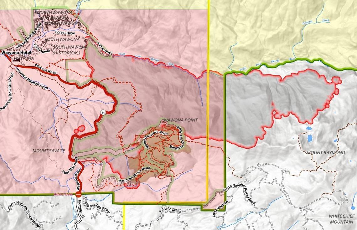
The main growth of the fire in recent days has been to the east, breaching the park’s boundary and the Mariposa/Madera county line between Monday and Tuesday. Sierra National Forest Supervisor Dean Gould issued an order Wednesday closing portions of the forest and forest roads in the Goat Meadow, Buffin Meadow and Long Meadow areas to the public through Aug. 1.
“The area in which the fire is burning contains a very heavy accumulation of fuels …,” according to a Thursday morning update from the National Interagency Fire Center. “This old growth habitat is a combination of dead large-diameter trees and timber litter on the ground, many feet thick in some cases, in combination with thick growing conifers and shrub, much of which has been untouched for decades.”
The southern entrance to Yosemite National Park from Highway 41 remains closed, as is the popular Mariposa Grove. The community of Wawona and surrounding areas in the southern part of the park remain under mandatory evacuation orders, but the rest of the park is open. The community of Yosemite West is accessible from the north via Wawona Road.
Firefighters are “feeling much more comfortable” about the Wawona area on Thursday morning, said Matt Ahearn, deputy operations chief with the California state interagency team that is managing the firefighting effort.
Crews are maintaining defensive positions around the buildings in the enclave. But, Aheard added, “there is still a threat” from fire and heat that’s been detected in portions of the drainage of the Merced River’s south fork east of the community.
“We’re going to try to work some crews in there to get up on the slopes and deal with those heat sources,” he said.
The rest of the park remains open, with visitors advised to enter Yosemite National Park using Highway 140 from Mariposa or Highway 120 from Manteca, Jamestown, and Groveland.
Incident commanders said containment lines appear to be holding around portions of the Mariposa Grove, the stand of more than 500 mature giant sequoia trees, some of which are more than 2,000 years old. The fire started along the Washburn Trail within the grove, but over the past week firefighters have established lines at the northern and western portions of the grove. No major damage has been reported to any of the huge trees.
“Mariposa Grove is in a very good place,” Ahearn said Thursday. “We’re going to put some specialty crews in there to work deeper into the grove, clean it up, but we’re very close to tying all the dots together at Mariposa Grove.”
Concern remains for the fire’s continuing spread at its northeastern section, where the wildfire’s behavior has included “runs of intense fire in the crowns of trees,” according to Thursday morning’s situation report. Continued warm and dry weather are likely to add to more active fire, especially in the warm afternoons.
“We fully expect fire to work its way down into Iron Creek today,” Ahearn reported. “Last night infrared flights were putting it four-tenths of a mile from the bottom of Iron Creek with continued spot fires working itself east.”
Fire crews are also preparing for the potential for the fire to spread both to the northeast and to the south.
To the northeast, helicopter attack crews are going to work into the area around the Buck Meadow Cabin. “We’re going to get in there and start protecting that structure,” Ahearn said, “putting structure wrap around it and preparing it to receive fire.”
To the southeast, new contingency groups have been established and heavy equipment is on its way for “putting a box” around the area from Highway 41 up to Raymond Mountain, the southern end of Iron Creek toward Grizzly Creek “so we can get a contingency line around the top side of Iron Creek when fire gets into Iron Creek,” Ahearn said.
Because there was no lightning on the day that the fire started, according to Yosemite National Park Superintendent Cicely Muldoon, it appears the fire was caused by people. However, incident managers say the cause is under investigation.
