Yosemite wildfire update: Containment grows but wind, heat could further drive flames
Firefighters expect the Washburn Fire burning in Yosemite National Park will continue to grow in the coming days, with high daytime temperatures and low humidity contributing to the blaze.
Moving forward, fire officials say they are sending specialized “hot shot” firefighters to address some of the most serious areas of concern
The wildfire, which began July 7, expanded by about 400 acres since Thursday morning, growing to 4,759 acres as of early Friday. But containment of the fire has also increased, with fire lines completed around 31% of the fire’s perimeter, according to the latest report from the National Interagency Fire Center.
The cause of the Washburn Fire remains under investigation, Yosemite’s chief ranger Kevin Killian and park superintendent Cicely Muldoon said Thursday night.

As of Friday, more than 1,500 firefighters have been deployed on the fire, including 36 ground crews, 99 engines and 14 firefighting helicopters, as well as airplanes dropping fire-retardant chemicals where they are needed.
“High pressure over the region continues to produce warm and dry conditions during the day and mild and moderate humidity recovery at night,” the national fire center reported on Friday morning.
“The prevailing winds will be out of the southwest, but most of the fireline will be impacted by terrain-driven flow. Higher elevations on the eastside of the fire could see gusts up to 20 mph.”

When may evacuees return to Wawona?
As the fire grows with sometimes-intense activity to the east in the Sierra National Forest, efforts to secure fire lines on the western portion of the fire to protect the residential hamlet of Wawona within the park are paying off, incident commanders told mountain-area residents at a community meeting Thursday night in Oakhurst.
Killian and Josh Boehm, incident commander with the California state interagency fire team overseeing the firefighting efforts, both said Wawona residents could likely return to their homes by Sunday.
That date is dependent on fire conditions, but “in close work with the fire team (and) a lot of discussions, we believe that Sunday morning is when we’re going to be able to repopulate Wawona with residents and property owners,” Killian said. “It’s going to be a little while before we get to allowing non-residents and the general public back into the area, but you’ve got to start somewhere, and we think we’re going to be there Sunday” for residents.
Killian added that he expects details about returning to Wawona to be available to residents sometime Saturday.
Boehm agreed with Killian, but said safety will be the key factor in finalizing plans to reopen Wawona to residents. “We’re going to get you back in your homes as quickly as possible — as soon as it’s safe to do so,” he said.
Boehm warned that residents could still see the effects of smoke in the area when they return. “It’s smoky,” he said. “Wind has been pushing it right over the community all day. I don’t want you all sitting in that. It’s bad enough that (the fire crews) have to.”
Where the fire is growing
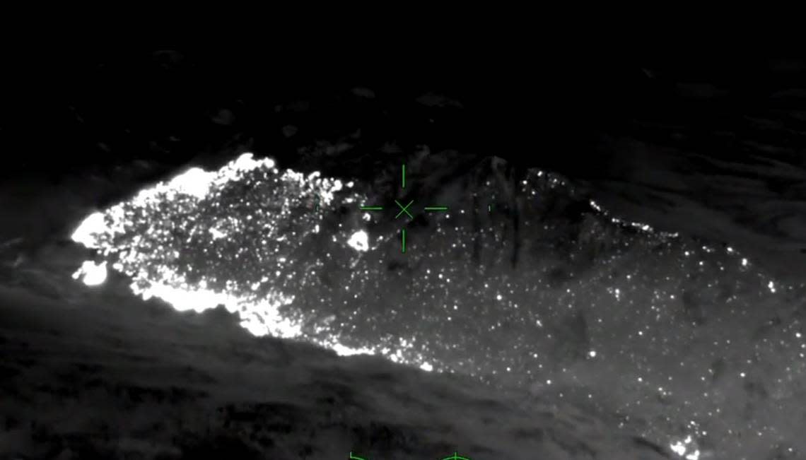
Aerial infrared video from Thursday night showed only scattered hot spots within most of the fire’s footprint in the southern area of Yosemite National Park from the Mariposa Grove, where the fire started on July 7, to the northwest at Wawona and north to the Merced River’s south fork.
The most intense areas of fire activity were to the east, in the Iron Creek drainage, and the northeastern edge of the fire along the south fork of the Merced River.
“Overall the incident is in a very good place,” Matt Ahearn, deputy operations chief with the state’s Interagency Incident Management Team that is coordinating the efforts, said in a Friday morning briefing.
Containment lines were holding well along the western and northwestern portions of the fire from the Mariposa Grove Road along Wawona Road (Highway 41) up to Wawona and the Merced River’s south fork.
In other areas, however, the fire remains uncontained.
“The further east we go … there’ s still significant heat,” Ahearn said in Oakhurst Thursday. At the fire’s eastern edge, flying embers are creating spot fires, perhaps a quarter mile ahead of the perimeter. Those fires “generate heat, and they’ll grow together and continue to do that,” he said. “It’s moving about a half mile, three-quarters of a mile a day, consistently.”
Iron Creek, he added, represents a junction of three different stream drainages with a lot of potential for the fire to spread. That’s prompting fire managers to deploy contingency groups to tie existing Sierra National Forest roads and ridge lines south and east of the fire’s current perimeter as a backup in case the fire expands.
Aside from the flames themselves, firefighters also face challenges presented by the weather, said Matt Mehle, a National Weather Service meteorologist who’s been assigned to advice Washburn Fire incident commanders in Yosemite.
“One is the heat,” Mehle said. “If you’re on the fireline, you’ve got all this gear on. … You know the heat is going to make things burn, but for the personnel on the line, it becomes a safety issue. They have to stay extra hydrated, drink even more fluids because they have that full gear on.”
During the daytime, low humidity or moisture levels in the air is what makes the fire more active. Typically, though, when evenings cool off, humidity increases and reduces the fire’s intensity. “That’s called a recovery, but on this fire we’re not really seeing a lot of recoveries (at night),” Mehle said. “Humidity is staying very low, so the fire isn’t able to recovery and kind of cool off at night. So it’s allowing for active fire behavior at night.”
Winds so far over the past week at ground level have been light, mostly driven by daytime heating of the hillsides and creating upslope breezes that can drive flames, Mehle said. On upper slopes, some gusts have blown at up to 20 to 25 mph.
In recent days and into the weekend, he added, “we’re stuck in a stagnant pattern” with a high pressure system sitting over central California, “meaning it’s going to remain hot and dry.”
Specialized firefighters being used
While Wawona appears to be safe, the fire remains uncontained in other parts of the northern perimeter and to the east. Ahearn said Friday that plans call for using helicopters to insert teams of specialized hot-shot firefighters into areas along the river’s south fork, where “fire is still holding a tremendous amount of heat down in the (river) bottom.”
“We still have a tremendous amount of work and really a heavy commitment of our hot shot crews and aerial resources to pinch off Iron Creek” at the fire’s eastern edge, Ahearn said.
On Thursday, Ahearn pointed out areas along the Merced River’s South Fork where hot shot crews – “the elite of the elite” among wildland firefighters – have been placed to keep the fire at bay. They are also examining areas near Iron Creek to determine when hot shots can safely drop in without danger of being overrun and endangered by advancing flames.
“They’re getting into some pretty extreme scenarios, terrain, cliffs and so forth” in the Merced River drainage, Ahearn said.
In the Mariposa Grove of iconic giant sequoia trees, where the fire began a week ago, containment lines are holding along most of the grove’s northern and western edges. “We continue to have crews working through Mariposa Grove, cleaning up as a contingency if fire were to roll out or slop over” across containment lines.
The Washburn Fire has now surpassed the Electra Fire, burning in Amador and Calaveras counties, as the second-largest wildfire so far this year in California. But it remains relatively small in comparison to some of the massive wildfires that have scorched portions of the state, including the central and southern Sierra Nevada range, in recent years.
But the Washburn Fire has garnered headlines across the U.S. and globally because of the threat that existed to the giant sequoia trees of Mariposa Grove. The sequoias are some of the largest trees on earth, and many of the 500 or so mature specimens in the Mariposa Grove are believed to be at least 2,000 years old.
