Yes, we’re ‘doing this again.’ Whatcom wakes up to snow and freezing fog. Now what?
Temperatures remained in the teens as several inches of snow fell in Whatcom County overnight and into the morning.
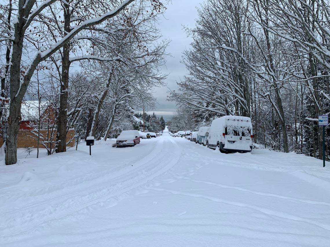
Fifteen inches of snow was reported in Blaine on the National Weather Service snowfall reports webpage. Glacier reported 14 inches. Wickersham, on the south shore of Lake Whatcom, reported 12 inches of snow. Bellingham also listed 12 inches, Lynden almost 11 inches.
“Please stay home if you can,” the Blaine Police Department said on social media at 4 a.m. Tuesday, Dec. 20. By 9 a.m., the department posted that it “Looks like most areas of Blaine ended up with around 14 to 16 inches of snow!”
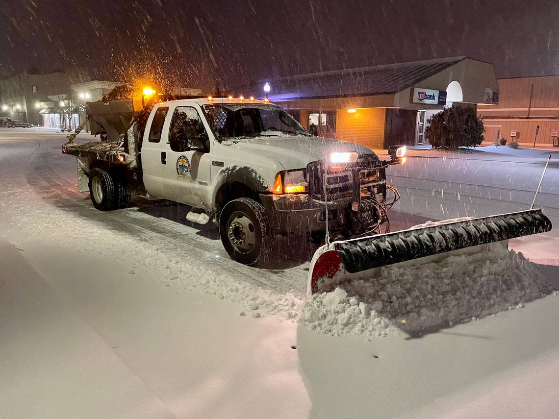
“The worst of this winter weather is in Whatcom County where we have compact snow & ice on several roads. Crews continue running plows 24/7 but the wind is blowing snow back over the road,” according to a Washington State Department of Transportation social media post at about 6:30 a.m.
Visibility improves heading south to Skagit County but there is snow on the road, the post said. “Hills, bridges, on- and off-ramps, overpasses & intersections may be particularly slick. Please drive for your comfort level or consider using public transportation, if possible.”
Cross-state travel is going to be extremely challenging as heavy snow will continue, according to a Washington State Department of Transportation social media post. Chains are required on I-90 Snoqualmie and U.S. 2 Stevens passes. Be prepared for potential delays/closures.
“It’s a ‘don’t go out unless you have to’ type of day. We have crews working around the clock, but ongoing snowfall makes travel conditions difficult! Please be extra cautious while driving and give plows plenty of room,” Whatcom County Public Works said on social media.
At 5 a.m. Bellingham International Airport reported snow and freezing fog. Washington State Department of Transportation cameras in Bellingham, Ferndale, Lynden and Sumas were showing fog and snowy roads.
WSDOT North tweeted late Tuesday: “I know what you’re thinking. ‘We’re doing this cold thing, again?’ Frigid temps, slick conditions & a winter weather advisory will make your AM commute extra wintry.”
If you plan to head out to enjoy the snow, Squalicum Creek Park sledding hill is open and Fairhaven Park is another popular location.
“Our crews are having trouble getting to some parks (Cordata and Lake Padden) due to wind and very cold temperatures,” Nicole Oliver, Bellingham Parks and Recreation director, told The Bellingham Herald.
“Anecdotally, I heard from friends that it’s too cold to be out for long,” she said, and she urged people to walk or ski to parks and trails rather than drive.
And here..we..go.
Pushing a car that got stuck along 539 in Bellingham. Snow is piling up on roads and lots of cars getting stuck and spinning tires. If you don’t have all wheel drive, stay home. On second thought, just stay home. #wawx pic.twitter.com/M2YA5NIAAn— John HopperstadTV (@JohnHopperstad) December 20, 2022
Weather forecast
A winter storm warning continued until 7 a.m., according to the National Weather Service forecast. Whatcom County Public Works posted that snow accumulations of 2 to 8 inches were expected.
Very cold temperatures are expected through Thursday, Dec. 22, with record-low temperatures possible. The temperature was 16 degrees overnight at Bellingham International Airport.
Low temperatures by Thursday morning could be 10-15 degrees across Puget Sound, with single-digit temperatures into the areas away from the water and in Whatcom and Skagit counties, according to the forecast.
1/3 Good morning, Northenders! It looks like per usual the worst of this winter weather is in Whatcom County where we have compact snow & ice on several roads. Crews continue running plows 24/7 but the wind is blowing snow back over the road. pic.twitter.com/N1mZuODlDu
— WSDOT North (@wsdot_north) December 20, 2022
Another system is on the way for the weekend, increasing the odds for snow before warming up and likely transitioning to rain, according to the 9 a.m. Tuesday weather service forecast.
Moderate to heavy lowland snow is expected through Tuesday evening. Snow is expected to continue falling through much of the day before tapering into early Wednesday.
Cold weather
City and school offices closed due to the cold.
And with very cold temperatures expected Wednesday, Dec. 21, and Thursday, they warned of impacts on vulnerable populations such as the homeless, pets, and those without adequate access to heating. People outside may suffer from frostbite and/or hypothermia. Exposed pipes may be damaged by freezing conditions.
The beginning of #Bellingham #Snow pic.twitter.com/zYgRwKF7o3
— George Mundell (@GeorgeMundell) December 20, 2022
Road2Home will activate the Bellingham Severe Weather Day Use Warming Center inside the Bellingham Central Library lecture room from 9:30 a.m. to 5:30 p.m. Tuesday and Wednesday.
Lighthouse Mission Ministries provided overnight shelter to 280 men and women Monday night, Dec. 19, at Base Camp and its overflow shelter run by volunteers from Christ the King Community Church in Bellingham, according to Hans Erchinger-Davis, president and CEO of Lighthouse Mission Ministries.
“We are thankful for the support of Christ the King Community Church and their many dedicated volunteers who run the overflow shelter on nights like these,” said Erchinger-Davise complex needs,” Erchinger-Davis said. “It’s continued motivation to get the new facility off the ground in Old Town, so no one gets turned away.”
Travel impacts
Lowland snow accumulations are likely on primary and secondary roadways resulting in travel delays and road closures are likely, according to the weather service.
The Port of Bellingham’s snow removal team has been working continuously to maintain “operationally acceptable surface conditions” and the airport has remained open. However, a number of flights mainly to Seattle have been canceled due to conditions there, according to an email from the port. All travelers are encouraged to check flight status with their airlines regarding their flight status.
Nearly 400 domestic flights in and out of Seattle-Tacoma International Airport were delayed and canceled throughout Monday, according to the Associated Press.
Alaska Airlines said it has also canceled roughly 100 flights on Tuesday, “with more cancellations possible, depending on the weather,” KOMO-TV reported.
#snohomishcounty N5 near MP206 two lanes are blocked for a multi vehicle collision with no injuries. This is a reminder with snow in most of the Pacific Northwest to #slowdown. With snowy/icy conditions remember to increase following distance too. #drivesafe #itssnowing pic.twitter.com/J3LYiPwMCS
— Trooper Kelsey Harding (@wspd7pio) December 20, 2022
Just after midnight all lanes were open after an early collision partially blocked the right lane of Interstate 5 northbound at Slater Road. No other major collisions were reported by the Washington State Patrol in Whatcom County. A collision on I-5 northbound at Samish Way blocked the left lane until it was cleared about 8 a.m.
Areas of significant ice accumulation may result in tree damage, power outages, and difficult air and road travel conditions. Widespread tree and powerline damage could result in power outages that could last several days. Puget Sound Energy did not list any outages in Whatcom County Tuesday morning.
Heavy mountain snow is expected, especially for Snoqualmie and Stevens passes through Tuesday night with 12-20 inches of snow possible. If you’re traveling over the passes on Tuesday, check restriction updates from the Washington State Department of Transportation.
Snoqualmie Pass closed in both directions mid-day Tuesday due to multiple spin-outs.
Is your business or organization closed due to snow? Let us know at newsroom@bellinghamherald.com.
