Winter storm warning: Up to a foot of snow and hazardous conditions start Monday afternoon
Iowa will kick off the new week with its first significant snowfall of the winter. Widespread accumulation and hazardous conditions are possible throughout the state Monday into Tuesday.
Here's a look at the latest updates as the winter storm approaches.
Download the free Des Moines Register app and turn on notifications to get key updates throughout the day. Also sign up for the Daily Briefing to get the day's top headlines directly in your inbox each morning.
This breaking news coverage is being provided for free as a service to the community. Subscribe to the Des Moines Register to support the local journalists covering this story.
What is the forecast and when is it supposed to snow in Iowa?
Some portions of northwest Iowa are seeing light snow fall Monday morning. Most of the state will see widespread snow arriving Monday afternoon and evening and continuing through the morning hours on Tuesday.
Forecasters at the National Weather Service expect heavy snowfall — greater than 6 inches — south and east of a line roughly from Atlantic to Ames to Waterloo.
❄️It's still going to snow. A lot.❄️
🌨️Onset has slowed a bit, possibly avoiding evening commutes for many outside of western and southwest Iowa.
🚗If you must travel, be sure to prepare accordingly and let others know of your plans. #iawx#winterstorm#winterisherepic.twitter.com/PQJHCQfuKS— NWS Des Moines (@NWSDesMoines) January 8, 2024
Expect hazardous travel at times, especially during Monday evening and Tuesday morning commutes. Snow could fall at more than an inch an hour at times with white-out conditions possible, according to the NWS.
Is there a winter storm warning in Iowa?
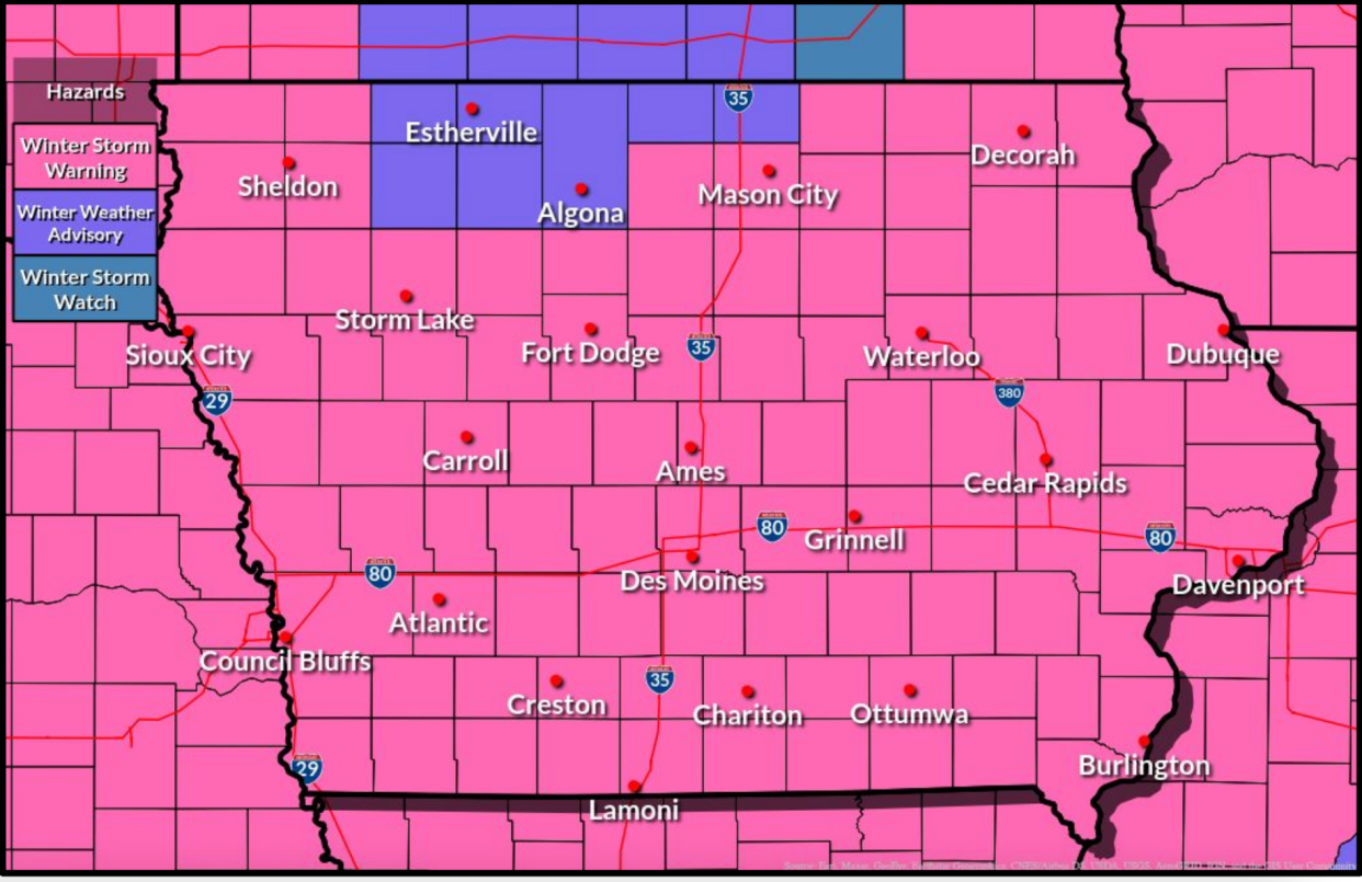
Yes. Most of the state is under a winter storm warning from 3 p.m. Monday until 6 p.m. Tuesday.
In eastern Iowa, the warning starts at 6 p.m. Monday and continues until 6 a.m. Wednesday.
How much snow will Des Moines get?
Most of the state will see heavy snowfall from this storm.
In Des Moines, forecasters expect 7-11 inches of snow. Snow could arrive as early as 9 a.m. Monday, but the heaviest snow is likely early Tuesday morning.
How much snow will Ames get?
Ames is also likely to see heavy snowfall, with forecasts calling for 6-10 inches. Snow is likely to arrive around noon and be heaviest in the late evening and early morning hours.
How much snow will Iowa City get?
A prolonged strong winter storm is expected Monday night through Wednesday morning. Accumulating snow and blowing and drifting snow is expected. Travel will become difficult. A winter storm warning is now in effect. pic.twitter.com/zIOldKEppy
— NWS Quad Cities (@NWSQuadCities) January 8, 2024
It will take longer for snow to arrive in Iowa City and its surrounding areas, but that area of the state is expected to see some of the highest snowfall totals, according to the NWS. Snow should arrive in the evening on Monday and continue through most of the day on Tuesday.
Current forecasts call for 9-13 inches in the Iowa City area, with as much as 15 inches possible in areas to the south.
What Iowa schools are closing today?
A few dozen schools are closing Monday or dismissing classes early. Check with your local district for the latest updates.
Schools in the Des Moines metro will hold classes on Monday.
Des Moines Public Schools has canceled all evening activities for Monday and plans to start classes two hours late on Tuesday. Officials are monitoring conditions and said they will review that decision on Monday evening and cancel Tuesday classes if necessary.
How do I check Iowa DOT road conditions?
As of 7:30 a.m. Monday, most roads in Iowa were seasonal. Some roads in far northwest Iowa were listed as partially covered.
More details: How to check Iowa road conditions, DOT cameras amid winter storms
You can check road conditions online through Iowa 511, with an interactive map that can show you road closures, winter weather warnings, interstate cameras, crashes and more.
If you don't have internet, you can call 800-288-1047, or 511 for updated road conditions.
Winter driving tips: How to keep safe while driving on slick Iowa roads
Are parking restrictions in place due to the winter storm in Iowa?
Several cities across the state are activating their snow ordinances, which often restrict parking on residential streets.
Des Moines snow parking rules: Where and when it's safe, and where you could be ticketed
In the Des Moines metro, the following cities have announced restrictions:
Altoona: Parking ban on all city roads begins Monday.
Ames: Snow ordinance goes into effect at 8 p.m. Monday and bans parking on designated snow routes marked with red and white signs. The ordinance remains in effect until streets are completely plowed curb to curb.
Bondurant: Snow ordinance bans parking on all public streets starting at 9 a.m. Monday until 24 hours after the snow stops.
Grimes: Parking is banned on all city streets from 6 p.m. Monday to 6 p.m. Tuesday.
Johnston: Parking is banned on all city streets from 6 p.m. Monday until 5 p.m. Tuesday
Indianola: Ban starts when snow falls and continues for 48 hours after snow stops or until streets are cleared.
Waukee: Parking is banned on all streets from 5 p.m. Monday until 5 p.m. Wednesday.
West Des Moines: Parking is banned on all streets from 6 p.m. Monday to 5 p.m. Tuesday.
This article originally appeared on Des Moines Register: Iowa winter storm warning: Heavy snow, poor road conditions expected
