Winter storm turns deadly, creating travel nightmares and thousands of power outages


An intense and deadly winter storm, the first major weather system this season to hit some parts of the eastern half of the United States, triggered warnings in more than a dozen states and wreaked havoc on the roadways, causing hundreds of accidents, leading to at least two fatalities and spurring hundreds of thousands of power outages.
The storm started before the Martin Luther King Jr. holiday weekend in the Midwest. Des Moines International Airport received 14.3 inches of snow while surrounding areas in Iowa got at least a foot of snow. According to the Minnesota Department of Transportation, multiple accidents occurred on Interstate 35 early Saturday morning, and many other vehicles spun out or stalled as the snowstorm created treacherous driving conditions on the roadways.
As the weekend got underway, heavy snow was reported in Arkansas, with multiple areas in the state picking up more than 5 inches of snow by lunchtime Saturday. While no snow accumulated, light snow flurries were recorded as far south and west as Dallas, Texas.
The highest Southern snowfall total was recorded in Valley Springs, Arkansas, with a total of 14 inches of snow. Some other areas in the South recorded more than a foot of snow, including East Flats, North Carolina. Leesburg, Mississippi, picked up 9 inches of snow, while Clarksville, Georgia, recorded 5.6 inches. Higher elevations played a big role in snow accumulations across parts of the south-central U.S. The National Weather Service in Little Rock, Arkansas, reported 1.6 inches of snow on Sunday morning, while just down the street from its offices, at a lower elevation, only a trace of snow accumulated.
CLICK HERE FOR THE FREE ACCUWEATHER APP
One place that managed to escape accumulating snowfall again was the city of Atlanta. Even though snowflakes fell in the Atlanta area during the winter storm, not enough measured up to end the snowless streak. A few snowflakes fell in the city, as well as outside the city, but only a trace of snow was officially recorded -- not enough to meet the 0.10-inch benchmark that is officially considered measurable snowfall.
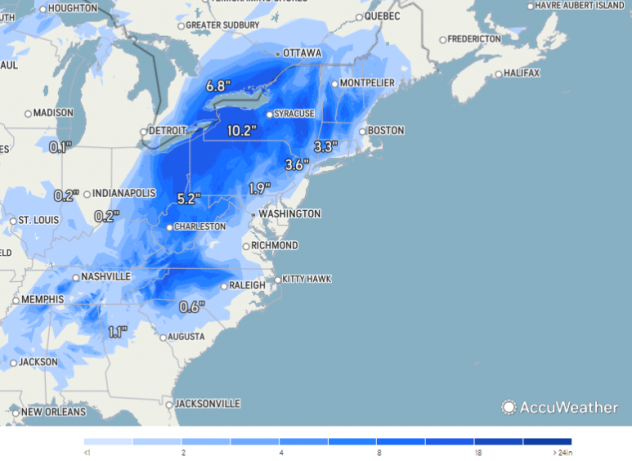
 |
AccuWeather's 24-hour snowfall estimate shows the approximate amounts of snow that fell during the storm, as of Monday morning Jan. 17, 2022. May not include all reports. |
Snowflakes have fallen twice in Atlanta in 2022, but in both cases, it amounted to only a trace. Measurable snow has not fallen in Atlanta for 1,460 days, which is the second-longest streak on record. If the city can make it to Feb. 4 without any accumulating snowfall, it would set a new record for the longest streak without measurable snow.
While snow, sleet and freezing rain were the biggest concerns across the Southeast, severe weather of another kind was also a major concern in Florida on Sunday morning. Three people were injured as an EF2 tornado touched down near Fort Myers. The twister spawned wind speeds of up to 118 mph, the NWS in Tampa Bay confirmed Sunday afternoon. More than 100 homes were damaged as the twister carved a path that was 1.8 miles long and up to 125 yards wide.
According to the NWS, multiple tornadoes also touched down on the opposite coast in southeastern Florida Sunday morning.
Power outages, plane cancellations and accidents all soared to dramatic numbers as the winter storm continued to drop a wintry mix of snow, sleet and ice. In North Carolina, authorities said the storm played a role in the death of two people in a crash Sunday afternoon, NBC News reported. A vehicle carrying a driver and a passenger traveling southbound on Interstate 95 veered off the road and struck several trees in a median. Both the driver and passenger were pronounced dead at the scene.
Also in North Carolina, a tractor-trailer slid off the Highway 147 bridge in Durham Sunday afternoon, leaving the truck dangling off the overpass as a result of the icy roads, WRAL reported. The cab of the truck appeared to land upright on the road below, while the trailer hung vertically from the bridge. The driver was taken to the hospital and was expected to be okay.
The storm complicated not just roadway traffic, but air traffic as well. Over 1,220 flights in and out of North Carolina's Charlotte Douglas International Airport were canceled Sunday, accounting for 95% of the flights out of Charlotte and 92% of the arriving flights that day, according to FlightAware.com. Air traffic trouble continued into Monday, though to a lesser extent. Roughly a third of the flights scheduled to depart from Charlotte were canceled, as were 29% of the flights scheduled to arrive in the Queen City. With both arrivals and departures combined, roughly 430 flights at Charlotte Douglas International Airport were canceled Monday.
More than 200,000 customers were without power in the eastern U.S. as of Monday morning, according to PowerOutage.US. Both North and South Carolina topped the list for the most power outages, with both states reporting more than 31,000 customers without service. By the evening hours, more and more customers saw their power return as crews continued their work.
As the storm moved northward into Virginia, police responded to 482 crashes and another 486 disabled vehicles across the commonwealth on Sunday between midnight and 8 p.m., EST., according to the Virginia State Police. There were no reported traffic deaths.
In Massachusetts, utility crews prepared for the intense winds, calling on help from New Jersey, Michigan and even Canada, AccuWeather National Reporter Jillian Angeline reported. Residents from Cape Cod who spoke with Angeline said they were rushing home since they didn't know how the incoming winds would impact the ferry schedules.
 |
Overnight Sunday into Monday, the storm moved into the Northeast producing more than a foot of snow in some areas. The winter storm, combined with lake-effect snow, dumped 28 inches of snow in Ashtabula, Ohio, and 22.5 inches of snow in Harpersfield, Ohio, both a little over an hour northeast of Cleveland, Ohio.
Five miles north of Harpersfield, Storm Chaser Brandon Clement spoke with T.J. Olekshuk in Geneva, Ohio, who was struggling to clear out the snow fast enough to keep his business open during the early hours of Jan. 17. He told Clement he had arrived at 10 p.m. EST on Sunday.
"Too bad we didn't have it [the snow] on Christmas, you know, because we had a green Christmas," Olekshuk said. "It is what it is. Gotta love northeast Ohio."
As the snowfall persisted during the early hours, he added that it was difficult not just for himself to keep up, but the snowplows as well, which he had seen going up and down his street as the snow continued to erase any previous progress.
"These guys have been here all night long in and out of here, running two or three trucks out here," he said. "They can't keep up with it either."
More than 900 snowplows continued to treat and plow state and U.S. routes outside municipalities as of early Monday evening, according to the Ohio Department of Transportation. They will be treating and clearing all interstates as well except for the Ohio Turnpike.
 |
T.J. Olekshuk tells Brandon Clement that the persistent snowfall was difficult to keep up with in Geneva, Ohio. (Brandon Clement/LSM) |
Buffalo, New York, set a new daily snowfall record with the city picking up 17.6 inches of snow, completely smashing the previous record of 8.3 inches, which was set back in 1958. A security camera captured an incredible time-lapse video of the record-breaking snow accumulating during the winter storm on Monday.
Other notable snowfall totals came out of the interior Northeast, with Kenmore, New York, recording 22.8 inches of snow on Monday. Right near the Ohio-Pennsylvania state line, Cherry Hill, Pennsylvania, came close behind with a total of 16 inches of snow, and Deerfield, New Hampshire, measured 9.0 inches. The National Weather Service office for Pittsburgh, located in Moon Township, Pennsylvania, measured 9.1 inches of snowfall as of late Monday afternoon. The last significant snow event for Pittsburgh was Dec. 16, 2020, when the city saw 9.3 inches of snow, according to the National Weather Service. An astonishing amount of snow fell in Harborcreek, Pennsylvania, which reported 22 inches total on Monday.
The 16.2 inches of snow in Buffalo on Monday nearly doubled the old daily record of 8.3 inches set in 1958.
Coastal areas like Long Island, the Connecticut shoreline and Rhode Island were on the wet and windy side of the storm, receiving mostly rain and gusty winds. Captree State Park on the south shore of Long Island recorded wind gusts of 69 mph. A wind speed of 65 mph was recorded in Narragansett, Rhode Island, while Norwalk, Connecticut, recorded a wind speed of 62 mph.
The Mount Washington Observatory is known for its extreme weather conditions, and the snowstorm hitting the Northeast isn't holding back. Conditions at the top of the 6,288-foot-tall mountain in New Hampshire were blizzardlike with winds gusting over 140 mph.
Flood sirens were sounded in Milford, Connecticut, Monday morning to alert residents to move their vehicles to higher elevations, Ryan Breton, a meteorologist for Fox61 in Connecticut, reported. Rescues were underway in Niantic, Connecticut, as waterfront homes were pummeled by waves crashing ashore.
A coastal flood warning was in effect until 1 p.m. EST for New York City, Long Island, northern New Jersey and coastal Connecticut. Many coastal towns had street flooding Monday morning as high tide coincided with the strong winds.
The blast of wintry weather will end as quickly as it arrives. Monday night, snow is expected to wind down, and conditions should be favorable for crews to clear the roads.
The blast of wintry weather ended practically as quickly as it arrived. By midday on Monday, the brunt of the storm had moved north of Boston and was dumping heavy snow across parts of the upper reaches of Vermont and Maine -- where it dropped upwards of a foot of snow in some locations -- and into eastern Canada. Cabot, Vermont, reported 20 inches of snow by the end of Monday.
AccuWeather forecasters say the longest stretch of cold air this season will arrive in the U.S. this week, packing a punch of Arctic air.
For the latest weather news check back on AccuWeather.com. Watch the AccuWeather Network on DIRECTV, Frontier, Spectrum, fuboTV, Philo, and Verizon Fios. AccuWeather Now is now available on your preferred streaming platform.
