A white Christmas in Boise? ‘I think we’re going to have that,’ says one meteorologist
A few rounds of snow are likely to hit Boise over the next few days, dumping a couple of inches of fresh powder and giving the city a solid chance for a white Christmas.
A brief storm will hit the Boise area on Tuesday night into Wednesday morning, dropping less than an inch of snow, meteorologists said. But a second storm starting Thursday night will produce the snow that still should be around come Christmas Day.
The National Weather Service defines a white Christmas as having at least an inch of snow on the ground on Dec. 25, which is Sunday.
“I think we’re going to have that,” National Weather Service meteorologist Les Colin told the Idaho Statesman on Tuesday.
“It’ll start getting sloppy on Christmas day,” Colin continued. “We may go above freezing, so we might be a bit wet and sloppy, but I think there’ll be more than an inch of snow on the ground.”
About an inch of snow will drop from the second storm this week and stick around, thanks to very cold temperatures. The Weather Service forecasts a low of 4 degrees early Thursday morning, and temperatures won’t climb back to freezing until Saturday.
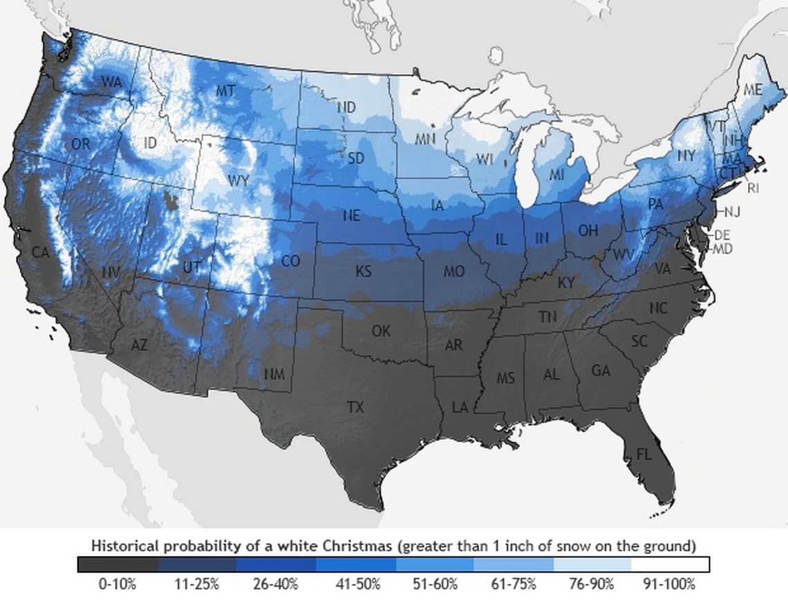
A Christmas without snow on the ground is much more common than not in Boise.
According to weather data from 1981 to 2010, Boise has about a 26%-40% chance of a white Christmas, marking it as one of the lowest chances in Idaho — the rest of the state is near a 100% chance.
Areas throughout Central Idaho will receive between 3 and 7 inches of snow, Colin said, adding to an already deep layer after weeks of heavy snowfalls for the region.
As of Tuesday morning, Bogus Basin reported 41 inches of snow at its base, while Brundage Mountain outside McCall reported 36 inches. Sun Valley has a 55-inch base.
Bitterly cold wind-chill temperatures
Dangerously cold arctic air is flooding a large part of the United States this week. The National Weather Service in Cheyenne, Wyoming, forecasts wind chills of 70-below zero for some parts of the state, while parts of the upper and central Midwest will experience wind chills of 40 below.
We can not emphasize enough - the #cold air and wind chill forecast tomorrow (Wed) night thru Thursday feature some of the most extreme values you will ever see!
Please take precautions: Check on elderly/vulnerable, protect pets, shelter livestock, cover exposed skin! #WYwx #NEwx pic.twitter.com/aFFqnCXftk— NWS Cheyenne (@NWSCheyenne) December 20, 2022
Forecast confidence has increased in the upcoming winter storm; however, exact snow amounts remain uncertain at this time.
We have high confidence in:
- Bitterly cold temps Thu-Sun
- Gusty winds Thu & Fri
- Blowing snow reducing visibilities.
- Travel will be hazardous, esp. Thu pic.twitter.com/BwLqUJ8w46— NWS Kansas City (@NWSKansasCity) December 20, 2022
Wind chill is not a true temperature reading but more accurately records how cold it feels outside due to the body losing heat as cold wind blows past.
Boise won’t experience such extremes, but Colin said he expects wind-chill temps to bottom out at 10-below zero around sunrise on Thursday.
Boise is protected from the current blast of cold air because of the continental divide, which follows the Rocky Mountains.
The arctic air is entering the U.S. from Canada on the eastern side of the divide and plunging into the Midwest. Once it has blown into the U.S. on one side or the other of the Rockies, it struggles to break across to the other side, Colin said.
“Cold air tends to hug the ground; with it being heavier, it goes down where the elevations are lower,” Colin said. “So it tries to get close to the ground, and it has to be deep enough to be able to spill over the continental divide.”
