New York City measures 1st snowfall of the season


The wait is over.
A storm system brought the season's first measurable snowfall to New York City early Wednesday morning. Before the sun could come up, the Big Apple's snow drought was officially over. And for the first time this winter, the streets of New York City were transformed into a winter wonderland.
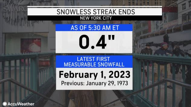
At Central Park in Manhattan, where the city's official weather station resides, 0.4 of an inch of snow was measured at 5:30 a.m. EST, the National Weather Service (NWS) confirmed.
"The snow that fell in New York City on Wednesday morning was due to just enough moisture in combination with a cold air mass to produce a light snowfall," AccuWeather Meteorologist Ryan Adamson said.
This is the city's latest first measurable snowfall since record-keeping began there in 1869. The previous record was on Jan. 29, 1973.
 |
Last week, the Big Apple beat the second-place record, which was set in 1966 and 2000, when snow was not measured until Jan. 20.
While the city has received precipitation since the winter season officially began, it has primarily come in the form of rain instead of snow due to abnormally high temperatures.
"The lack of snowfall this season is not for a lack of storms," AccuWeather Senior Meteorologist Dave Dombek said. "There have been precipitation events, [but the] temperatures were just too high for snow."
 |
Snow fell across parts of the Interstate 95 corridor on Wednesday morning. (AccuWeather Radar) |
Overall precipitation for the month of December was more than 2 inches above average, but the vast majority of that fell as rain instead of snow. January had more precipitation than normal, with the total nearly an inch above average, Dombek said.
As for snowfall, New York City is significantly below its season-to-date average. From Oct. 1 through Jan. 31, the city typically receives 14.3 inches of snow.
Although it certainly has been cold enough for snow at times throughout this winter season, and some flurries have been spotted, the most the city had recorded before Feb. 1 at Central Park was a trace of snow. But a trace amount of snow does not count as measurable snowfall, which meteorologists define as 0.1 of an inch of snow or greater.
 |
Now that measurable snow has fallen in the city, the snowless streak has ended. From March 9, 2022, to Jan. 31, 2023, or 328 days, there was no measurable snow in the Big Apple. This was the Big Apple's second-longest stretch of days without measurable snow in recorded history. The longest snowless streak in the city lasted 332 days and ended on Dec. 15, 2020.
Other cities located along the Interstate 95 corridor that were in a snow drought also received their first accumulating snow of the season on Wednesday, according to the National Weather Service. It snowed for several hours in Philadelphia, and Washington, D.C., before sunrise Wednesday morning, resulting in 0.3 of an inch of snow at Philadelphia International Airport and 0.4 of an inch at the NWS office near Dulles Airport in Dulles, Virginia. In Baltimore, 0.2 of an inch was measured.
"Following this morning's snowfall in New York City, no further snow is expected this week," Adamson said. "However, AccuWeather meteorologists are monitoring an Arctic blast that will reach the Big Apple on Friday. The cold should be short-lived, with temperatures back into the 40s by Sunday."
 |
Temperatures in New York City will feel like the Arctic on Saturday in Manhattan, with a morning low of 6 and afternoon temperatures only in the lower 20s. Forecasters say AccuWeather RealFeel® Temperatures will dip below zero at times as the air is funneled between the concrete canyons.
The record low temperature in Central Park on Saturday morning is 3 degrees Fahrenheit and was established back in 1918. AccuWeather forecasters say if the winds end up being more northerly than northwesterly, then there is a chance this record could be broken.
Experts warn that people who will spend any length of time outdoors should be prepared for the extreme cold, which can be dangerous for those with pulmonary conditions. The risk of frostbite on exposed skin will be high with the intense burst of Arctic air from Friday night to Saturday.
Want next-level safety, ad-free? Unlock advanced, hyperlocal severe weather alerts when you subscribe to Premium+ on the AccuWeather app.AccuWeather Alerts™ are prompted by our expert meteorologists who monitor and analyze dangerous weather risks 24/7 to keep you and your family safer.
