Spring flooding to ramp up over north-central US


Surging temperatures, combined with a surplus of snow from over the winter, will cause the spring flood season to ramp up with a vengeance in the coming weeks over the northern Plains and in part of the Upper Midwest, AccuWeather meteorologists say.
As temperatures climb into the 70s and 80s Fahrenheit from the central Plains to the lower Great Lakes and Northeast this week, warmer air will reach the deep snow-covered landscape of the northern tier of the central United States and initiate the long-anticipated spring thaw and flooding.
"There is a tremendous amount of snow on the ground over a large part of the northern Plains, as well as a lot of water locked up in that snow," AccuWeather Meteorologist Matt Benz said. "In many portions of the Dakotas, Minnesota, northern Wisconsin and northern Michigan, there is from 4-8 inches of water locked up in that snow." A maximum of 21 inches of water is held within the snow in a few places.
 |
Since average temperatures have remained below freezing in recent weeks in much of the region, a substantial amount of ice remains on area streams and rivers. As temperatures soar this week, that ice will break up and begin to move downstream. Where it gets bottled up, ice jam flooding can occur, experts say.
"In some cases, where temperatures dip below freezing at night, the thaw will be gradual and flooding may be limited," Benz said. The thaw, and perhaps the greatest risk of flooding, will be most dramatic on the southern edges of the vast snowpack, such as in South Dakota, central Minnesota, northern Wisconsin and the Upper Peninsula of Michigan this week.
 |
AccuWeather meteorologists continue to monitor the potential for heavy rain that could worsen the long-term flooding potential.
A storm system with mostly rain will pivot from the West at midweek to across portions of the northern Plains and the Upper Midwest by late in the week. The latest forecasting data suggests that most areas should receive less than an inch of rain over the course of 12-36 hours from that storm. That sort of rainfall is not likely to be a major factor in runoff and potential flooding. Colder air that follows the storm will slow down the thaw process a bit.
 |
As runoff from the existing snow cover is released by the thaw and gradually moves from small streams to progressively larger rivers in the region, moderate to major flooding is anticipated on some larger river basins in the coming weeks. However, the situation over the northern Plains and the upper reaches of the Great Lakes is complex and can vary from one river watershed to another.
The Red River of the North tops the list of rivers that are likely to experience major flooding this spring.
"There has been a substantial amount of flood mitigation that has been completed with more underway for the major population centers along the Red River," Benz said. The biggest and most serious impacts along the Red River will likely be in rural areas due to cropland flooding and secondary road closures, he added.
A problem when flooding occurs along the Red River and others throughout the northern Plains is that the flat terrain can affect how long it takes for floodwaters to recede. Once water gets into the fields, it may take many weeks for it to leave and days to weeks before the ground is dry enough to plow and plant crops.
 |
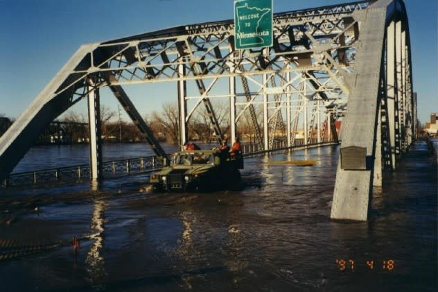
The National Guard transports U.S. Geological Survey personnel from East Grand Forks, Minnesota, to Grand Forks, North Dakota, via the Sorlie Bridge during record flooding on April 18, 1997. |
Other rivers in the north-central region that could experience moderate to major flooding include the James, Big Sioux, Minnesota, Crow, St. Croix, Wisconsin and Menominee. The James River at Ashton, South Dakota, is projected to reach major flood stage around April 15, according to National Weather Service hydrologists.
Flooding is also a certainty along the upper portion of the Mississippi River (north of St. Louis) in the coming weeks. Because of the large volume of water the Mississippi River handles, it can take many weeks for waters to rise, crest and fall.
While there are some locks and dams along the upper portion of the Mississippi, they are unlikely to prevent moderate flooding later this month and into May.
Major flooding - short of record high levels - is possible, especially if some large rainstorms wander into the region. If big rain events don't unfold across much of the upper Mississippi watershed, then major flooding may be avoided in most locations, AccuWeather forecasters say.
 |
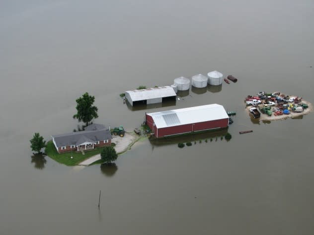
Upper Mississippi River flooding on June 26, 2008. |
While floods along the Mississippi River do not occur every year, there is typically flooding of varying intensity along some portion of the massive waterway every few years. Some of the most significant in recent decades occurred during the years 2019, 2017, 2014, 2011, 2008, 2002 and 1993. The floods of 2019, 2008 and 1993 were among the worst on record.
Along much of the Missouri River watershed, there has been less snow this winter relative to other parts of the northern tier of the Central states and farther southwest in western Colorado and Utah. Snowfall over the headwaters of the Missouri in Montana has been near to slightly above average during this winter.
In the short term, flooding along the Missouri River will be associated with ice jams and mostly on some of the tributaries. There are a number of large dams along the Missouri that should be able to handle near to slightly above historical average runoff from short-term snowmelt over the northern Plains and melting snow from the northern Rockies later in the spring and summer.
Want next-level safety, ad-free? Unlock advanced, hyperlocal severe weather alerts when you subscribe to Premium+ on the AccuWeather app. AccuWeather Alerts™ are prompted by our expert meteorologists who monitor and analyze dangerous weather risks 24/7 to keep you and your family safer.
