Snow squalls could lead to dangerous travel from Michigan to Pennsylvania into early Friday


Brief bursts of heavy snow and strong winds could imperil motorists by producing whiteout conditions into Friday morning as atmospheric energy moves from the Great Lakes to the Appalachians, according to AccuWeather forecasters.
This latest threat of heavy snow comes just a day after a larger winter storm moved through and dropped up to 8 inches of snow over parts of the region. AccuWeather meteorologists' primary concern with the squalls consists of a rapid reduction in visibility and quick accumulation of snow, which can make for dangerous travel conditions.
 |
Snow showers and heavier squalls began to develop in several bands by the midday hours on Thursday from southwestern Michigan into northern Indiana. The snow showers and squall will expand across a large portion of Ohio, West Virginia, eastern Kentucky, western Pennsylvania and southwestern New York through Thursday night.
While energy high up in the atmosphere will power the development of the heavy snow bands, some moisture will also be picked up from Lake Michigan and Lake Erie, adding some extra "juice" to the snow showers. This means that a quick 1 to 3 inches of snow can accumulate in many areas, despite the fact that most of the snow showers and squalls will last for as little as 15 or 30 minutes.
"Snow squalls are one of the most dangerous weather phenomena to drive in," according to AccuWeather Senior Meteorologist Adam Douty. "Visibility can rapidly fall to near zero, and roads can quickly ice over."
 |
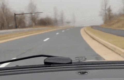
Snow squalls can lead to a rapid reduction in visibility for motorists, due to heavy snow and strong winds, as seen in this video captured by AccuWeather Senior Meteorologist Alex Sosnowski. |
By late Thursday night and Friday morning, the threat of heavier snow showers and squalls will diminish as the atmospheric energy moves out. A few flurries could still linger, however, and some roads may still be icy or snow-covered for the Friday morning commute, leading to slick spots and travel delays.
Snow squalls have been known to lead to massive pile-ups on highways, as the onset of low visibility from heavy snow and strong winds can catch motorists who are traveling at a high rate of speed by surprise.
The best defense against the dangers of traveling in snow squalls is to delay or avoid travel during the time when they are expected. If that isn't possible, experts recommend that motorists try to safely exit the highway if they encounter a squall. If drivers are unable to exit the highway or any other road, they should reduce their speed and make sure their headlights are on.
 |
A section of multi-vehicle accident on Interstate 75 is shown in Detroit, Thursday, Jan. 31, 2013. Snow squalls and slippery roads led to a series of accidents that left at least three people dead and 20 injured on a mile-long stretch of southbound I-75. More than two dozen vehicles, including tractor-trailers, were involved in the pileups. (AP Photo/Paul Sancya) |
"The timing of the snow threat is another concern since the veil of night can make it even harder for motorists to see when a snow squall moves through," added Douty.
In the wake of Wednesday's snowstorm and the threat of snow squalls into early Friday, there are prospects of more wintry weather into the weekend and next week in parts of the region, forecasters say.
An Alberta Clipper storm will bring accumulating snow to cities such as Chicago and Detroit this weekend, while another storm may bring snow to areas farther south and east into the mid-Atlantic next week.
Want next-level safety, ad-free? Unlock advanced, hyperlocal severe weather alerts when you subscribe to Premium+ on the AccuWeather app. AccuWeather Alerts™ are prompted by our expert meteorologists who monitor and analyze dangerous weather risks 24/7 to keep you and your family safer.
