The year of extremes: Why 2021 has broken the mold for one region


Record bookkeepers in the Pacific Northwest need a break before they develop a writer's cramp.
The past 12 months have proven that 2021 just doesn't seem to care about climatological averages, let alone all-time records, for the Pacific Northwest region. Those living along the West Coast, particularly in Oregon, Washington state or the Canadian province of British Columbia, have almost certainly learned that by now.
The unconventional calendar year has been extreme from the start. Exacerbated drought set the stage for massive wildfires and helped create the conditions under which record-shattering heat waves occurred. After months of hazardous air quality levels and the hidden dangers of heat waves, the change of season has offered no reprieve.
In place of the droughts, wildfires and heat waves have come storm parades, atmospheric rivers and the Pineapple Express. Floods have wreaked havoc both on rivers and in burn scars, in major cities and small towns both south and north of the U.S.-Canada border.
Take the city of Abbotsford, for example. The Canadian city, located just north of the U.S. border in British Columbia, recorded its hottest day ever and its wettest day ever just 140 days apart.
From days of triple-digit heat in July to days of double-digit rainfall in October, the region has felt the effects of what may aptly be described as the most extreme weather year on record.
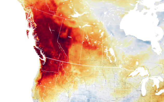
 |
The map above shows air temperature anomalies across the western United States and Canada on June 29, 2021. The map is derived from the Goddard Earth Observing System (GEOS) model and depicts air temperatures at 2 meters (about 6.5 feet) above the ground. The darkest red areas are where air temperatures were 36°F (20°C) higher than the 2014-2020 average for the same day. (NASA) |
"It has certainly been a year of extremes across the Pacific Northwest, including British Columbia," AccuWeather Senior Meteorologist Brett Anderson said.
And it may not be a one-year wonder, AccuWeather Chief Meteorologist Jon Porter warned.
"This type of 'weather whiplash' may become more common as the climate warms," he said.
The house of 2021 climate catastrophes was built on the foundation laid in 2020 and years prior. Drought that had long worried hydrologists and meteorologists worsened in the summer of 2020, creating a ripple effect that set the stage for a uniquely dangerous wildfire season.
With the enhanced drought came more intense blazes. From July to September, the National Interagency Fire Center kept its fire preparedness level at Level 5, its highest status, for 69 straight days - the longest stretch in U.S. history.
On top of the millions of acres of burned land, the fires also spewed hazardous smoke throughout the country, dropping air quality numbers to dangerously low levels.
 |
FILE - In this Tuesday, Aug. 31, 2021, file photo, an empty beach is seen after a mandatory evacuation was ordered due to the Caldor Fire in South Lake Tahoe, Calif. State fire officials say evacuation orders for the area were reduced to warnings as of 3 p.m. Sunday, Sept. 5. Some 22,000 people had been forced to flee the popular resort and nearby areas last week as the Caldor Fire roared toward it. (AP Photo/Jae C. Hong, File) |
"We're living in and literally breathing climate change through wildfires," Susan Prichard, a University of Washington forecast ecologist, told High Country News earlier this month.
When the drought wasn't fueling lung-burning wildfires, it sent the mercury in thermometers skyrocketing in other areas of the region.
In late June, the city of Lytton broke Canada's all-time high-temperature record when the mercury reached 121.3 degrees Fahrenheit. In the U.S., cities such as Seattle and Portland, Oregon, endured multiple historic heat waves that shattered state records and claimed several lives.
Then, before residents could catch their smoke-filled breath, the rain started pouring.
In both late October and mid-November, record-breaking rain fell along the West Coast, both above and below the border. In October, a monstrous bomb cyclone was responsible for demolishing rain records in San Francisco and Sacramento, while the ensuing storm parade left hundreds of thousands without power in California, Washington and British Columbia. Then, just weeks later, another atmospheric river in the region turned deadly, as a "Pineapple Express" storm dropped over 10 inches of rain in a 48-hour period, swelled rivers to record high levels and left hundreds of thousands in the dark once again.
"In both the extreme drought and record-setting heat waves, as well as the heavy rainfall, which recently led to devastating flooding, we see another hallmark of climate change impacts being observed around the world — just how extreme the events can get from a magnitude perspective," Porter said.
Porter added that had it not been for the extra amplification that occurred from a warming atmosphere and the extreme drought conditions, Lytton's temperature record would have been unlikely.
That volatility in weather conditions, a "weather whiplash," as Porter worded it, may become more and more common as the climate continues warming, he said.
"The juxtaposition of the severe drought and heat waves from this summer to just a few months later devastating flooding with excessive rainfall falling 'too fast, too furious' is particularly striking as it seems like the atmosphere quickly 'flipped a switch' - but it isn't the first time we've seen extreme drought come to a rapid end by a major rainfall and subsequent damaging flooding," he said. "For example, a multi-year drought in much of Texas came to a rapid end in 2015 with serious flash flooding."
According to Anderson, who has been studying the effects of climate change on the atmosphere for decades, it may be tough to pin the extremes on just one culprit. Citing multiple studies, he said there is a clear correlation between the continued warming of the planet and an increase in extreme weather events due to the warmer air in the atmosphere being capable of holding more water.
 |
A swollen creek flows under a washed-out bridge at the Carolin Mine interchange with Coquihalla Highway 5 after devastating rain storms caused flooding and landslides, near Hope, British Columbia, Canada November 17, 2021. (B.C. Ministry of Transportation and Infrastructure/Handout via REUTERS.) |
Porter concurred, adding that a warmer atmosphere " enables greater atmospheric moisture levels and helps amplify rainfall events."
"British Columbia, unfortunately, experienced this amplification effect on multiple severe weather events, which increased impacts to people and the economy," he said.
In the U.S., a large portion of the country has already seen that jump in extreme weather events over the past 20 to 30 years, Anderson added.
"Warmer-than-normal Pacific waters are likely providing more energy for these storms as they approach the coast," he said. "We are also under La Niña conditions, which tends to favor a stronger jet stream that is more orientated toward the Pacific Northwest and western Canada, which is directing more powerful storms into the region, setting the stage for storms that produce more precipitation and wind."
In factoring in those La Niña conditions, AccuWeather meteorologists weren't caught off guard by the intense storms of the recent months.
In August, Anderson provided his annual expertise for AccuWeather's Canada fall forecast, and he warned that the western portions of British Columbia could experience increased rainfall this autumn.
"Months in advance, AccuWeather meteorologists accurately forecast that the drought and wildfire season in British Columbia would quickly end with a series of moisture-laden storms delivering rain and mountain snows," Porter said.
For the latest weather news, check back on AccuWeather.com. Watch AccuWeather Network on DIRECTV, DIRECTVstream, Frontier, Spectrum, fuboTV, Philo, and Verizon Fios. AccuWeatherNOW is streaming on Roku and XUMO.
