What is El Nino and how does it affect the weather?


A major key to shaping weather patterns worldwide is found in the tropical Pacific Ocean, far from any mainland. Known as the El Niño-Southern Oscillation (ENSO), this climate phenomenon is the pattern that can create significant differences in average ocean temperatures and often plays a pivotal role in how global weather patterns unfold.
The ENSO pattern occurs in three stages. The neutral state indicates that sea surface temperatures in the tropical Pacific are near a long-term historical average, while La Niña results in ocean temperatures that are cooler than the historical average along with stronger surface winds.
 |
The third state is El Niño, which occurs when sea surface temperatures in the tropical Pacific rise to above-normal levels for an extended period of time. El Niño, Spanish for "little boy," was named in reference to Jesus Christ due to the timing of the warm ocean waters. The term originated from South America in the 1800s, when warmer waters around the Christmas holiday negatively impacted fish catches.
Low-level surface winds also tend to weaken during El Niños as well as shift direction. Instead of flowing from east to west along the equator, they tend to blow from west to east.
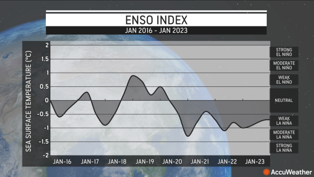
As shown by NOAA's ENSO Index graph, most of the last three years have been dominated by La Niña, but that streak has recently been declared over, and forecasts are now calling for neutral to El Niño conditions over the next few months.
 |
NOAA's ENSO Index between January 2016 and January 2023 |
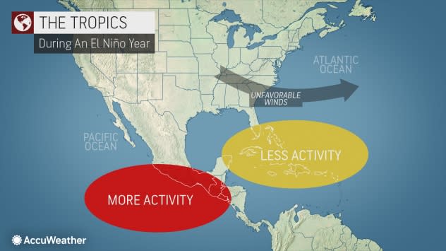
During an El Niño phase, the rising temperatures in the tropical Pacific can create significant changes in weather worldwide, including in the United States. The El Niño pattern has an impact on the number of tropical systems that can develop during the Atlantic hurricane season, and it can also influence weather events during the winter months.
"Typically, El Niño tends to peak during the winter months," AccuWeather Senior Meteorologist Dan Kottlowski said. "Often [this occurs] in November and December, but it can peak a bit later than that."
Storm tracks shifting farther south allow cooler and wetter weather to reach the southern portion of the U.S., affecting everywhere from California to the Carolinas. An El Niño winter spells a stormier fate for the southern and southeastern U.S. due to a split jet stream, which brings more tropical moisture, according to AccuWeather Senior Meteorologist Brett Anderson.
 |
According to the National Oceanic and Atmospheric Administration (NOAA), the likelihood of a wet winter season skyrockets by up to 90% during El Niño in parts of California, Texas and Florida among other states. For the Northeast, warmer conditions are felt during an El Niño winter, but the region is still susceptible to frequent snowstorms.
Outside of winter months, El Niño has a vast impact on the Atlantic hurricane season, with Kottlowski noting that El Niño "creates stronger vertical wind shear across the Gulf of Mexico, the Caribbean and the tropical Atlantic." Wind shear is defined as changing wind speed and direction with altitude, and can inhibit tropical development.
When wind shear is absent, a tropical cyclone's center is vertically aligned, keeping the cyclone intact and strengthening. However, upper-level winds coming over the top of a system can tilt the system in one direction and make it more difficult to intensify further. Kottlowski explained that this is similar to a spinning top. When completely upright, the top can spin continuously without issue. However, becoming angled or tilted, it can unravel and come to a halt.
Conversely, during La Niña patterns, less wind shear is found over the tropical breeding areas of the Atlantic basin. This can increase the chances of an above-normal hurricane season.
 |
According to Anderson, El Niño intensity can range in scale, depending on the strength of the lower-level winds in the central Pacific.
"Not all El Niños are the same, and other natural climate phenomena can also interact with El Niño, resulting in various seasonal impacts across the globe," Anderson said.
Kottlowski noted that El Niño patterns generally last between six to eight months, but in some cases can last up to a year and a half. There are also occasions where El Niño weakens during the spring, only to restrengthen over the summer months.
The longest El Niño on record lasted 18 months, according to NOAA.
Modern climate models, such as those used by NOAA's National Centers for Environmental Prediction, can predict El Niño up to a year in advance, using observation data from the Tropical Pacific Observing System that monitors changing conditions in the ocean and atmosphere.
Predicting when El Niño will occur can allow the U.S. to help its residents plan for extreme weather events associated with the pattern and can save the country billions of dollars in damage costs.
Want next-level safety, ad-free? Unlock advanced, hyperlocal severe weather alerts when you subscribe to Premium+ on the AccuWeather app. AccuWeather Alerts™ are prompted by our expert meteorologists who monitor and analyze dangerous weather risks 24/7 to keep you and your family safer.
