East Pacific to remain hotbed for tropical activity


AccuWeather meteorologists continue to monitor the tropical basins surrounding the United States for the next named storm. The Atlantic spawned three named storms ahead of the historical average pace this season, but development seems unlikely in the next week. The East Pacific, on the other hand, has at least two candidates that could become named storms.
One area of particular interest to meteorologists is a zone off the southern coast of Mexico that could be especially conducive for tropical development into the middle of the month.
"It's likely that the tropical wave moving through a zone of warm water south of Mexico could help to develop an area of low pressure, and eventual tropical depression, in this zone by the weekend," said AccuWeather Meteorologist Mary Gilbert.
According to Gilbert, in addition to the warm water, other conditions in the atmosphere are conducive to development, including weak wind shear. Wind shear, which is the change of winds with altitude, can inhibit tropical systems from becoming better organized when it is especially strong.
"Without much to stop the storm development into next week, anything that forms is likely to strengthen further and could become the third named tropical storm of the season," Gilbert said.
 |
The second of the two risk areas is also likely to form well south of Mexico. However, the area is even farther from Mexico and even less likely to impact land.
A general westward track is expected from both tropical waves should help to steer any storm and most of its impacts away from North America.
Direct impacts from any developing storm look unlikely, but some rough surf and strong rip currents could still reach the southern beaches of Mexico, warned Gilbert.
The next two storm names on the East Pacific list this year are Calvin and Dora.
Several tropical waves are expected to push off the west coast of Africa and over the Atlantic this week. However, they'll be no match for the hostile atmospheric conditions over the Atlantic Ocean right now.
Plentiful Saharan dust across the central Atlantic, combined with strong wind shear, is unlikely to allow for tropical waves to strengthen into a depression or storm in the coming week.
 |
Even without a defined tropical system, the lingering moisture from these tropical waves may continue to sweep across the Windward and Leeward islands of the Caribbean through the middle of the month.
In the meantime, so much dust is forecast to track across the ocean that it is likely to impact the Caribbean and portions of the southern U.S. through the weekend.
"Enough dust will be in the atmosphere to cause hazy skies and create colorful sunsets and sunrises," said AccuWeather Senior Meteorologist Adam Douty.
 |
Douty also warned that in locations where the dust is thickest and able to get closer to the surface, air quality could also turn poor.
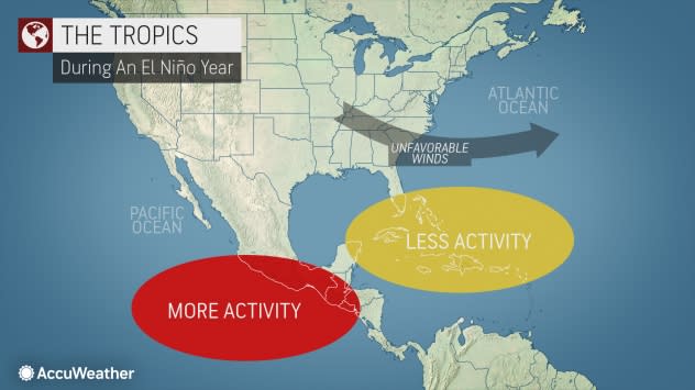
AccuWeather meteorologists predicted months ago that a strengthening El Niño pattern, which occurs when sea surface temperatures are above normal in central and eastern parts of the Pacific Ocean, would occur this summer.
An El Niño pattern causes the winds at higher levels of the atmosphere to dip southward and deep into the tropics more frequently in the Atlantic, resulting in more episodes of vertical wind shear. Vertical wind shear causes thunderstorms and convective clouds within emerging tropical disturbances to be tilted, disrupting tropical development.
As the East Pacific becomes more active, the Atlantic basin is more likely to be less active. When the next tropical system in the Atlantic does take shape, it will be named Don.
 |
Want next-level safety, ad-free? Unlock advanced, hyperlocal severe weather alerts when you subscribe to Premium+ on the AccuWeather app. AccuWeather Alerts™ are prompted by our expert meteorologists who monitor and analyze dangerous weather risks 24/7 to keep you and your family safer.
