Weather warning live: Storm Ciarán to bring flooding and strong winds to UK
The Met Office has warned of “strong winds and heavy rain” as Storm Ciarán is set to sweep across the UK later this week.
Ciarán is due to bring gusts of 80mph winds to areas along the south coast of England, with a small risk of some more exposed areas seeing wind speeds of up to 90mph. Meanwhile, up to 60mm of rain is expected to fall in some areas.
Met office Deputy Chief Meteorologist, Chris Almond, said: “Heavy and persistent rain will fall onto already saturated ground bringing a risk of further impacts such as flooding in areas that are already struggling to clean up from the heavy rainfall we have seen over the last week or so.”
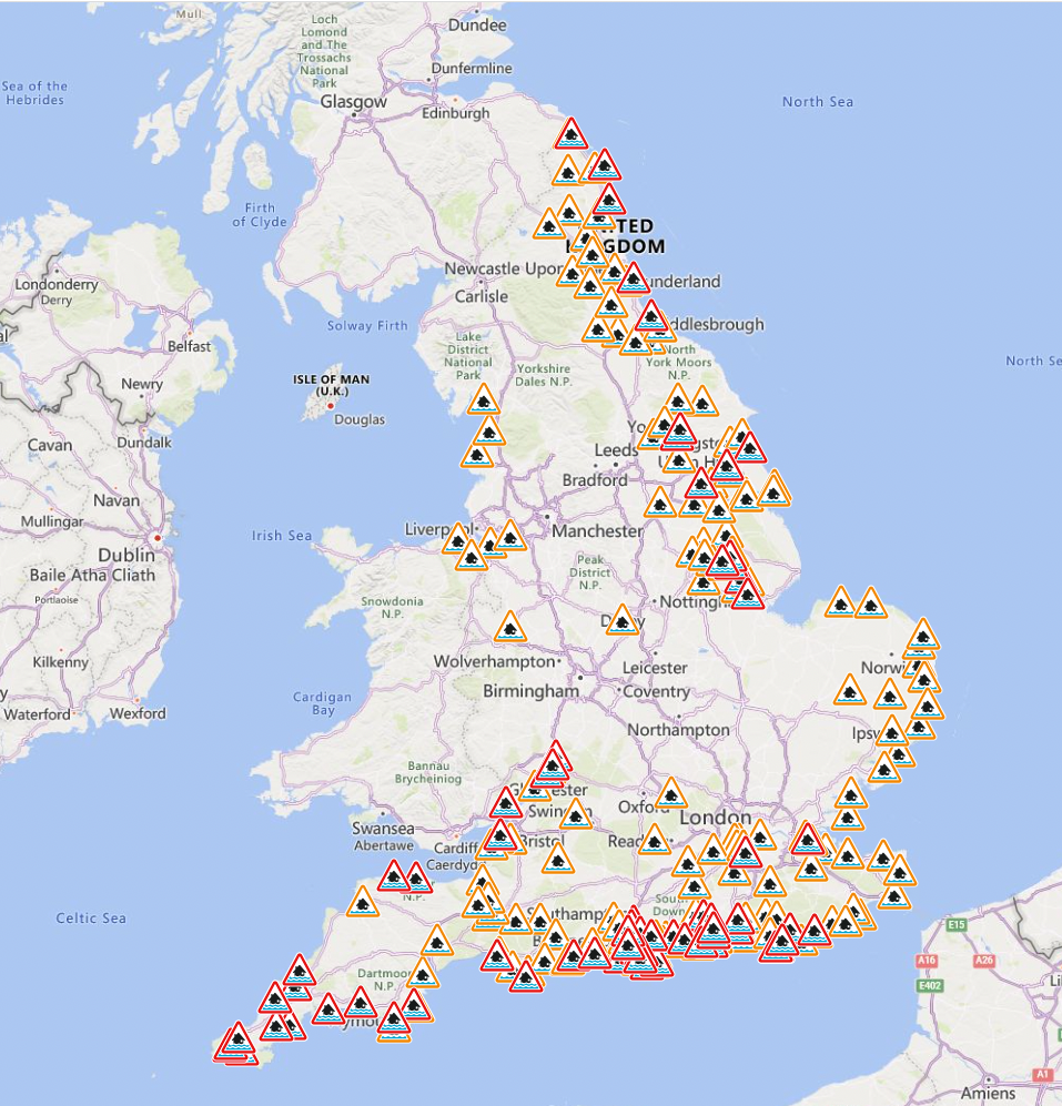
The Environment agency currently has a staggering 72 flood warnings in place across England and a further 172 flood alerts. Meanwhile in Scotland, 18 flood warnings and 11 flood alerts are currently in place.
The third named storm of this year’s season comes after areas across Scotland and north-east England were battered with the worst of Storm Babet, which caused serious damage and several deaths when it hit last week.
Key Points
Met Office name latest storm set to bring 90mph winds to the UK this week
Staggering number of flood warnings in place
Where will be affected?
How bad will the weather be?
Met Office issues new danger to life warning for today
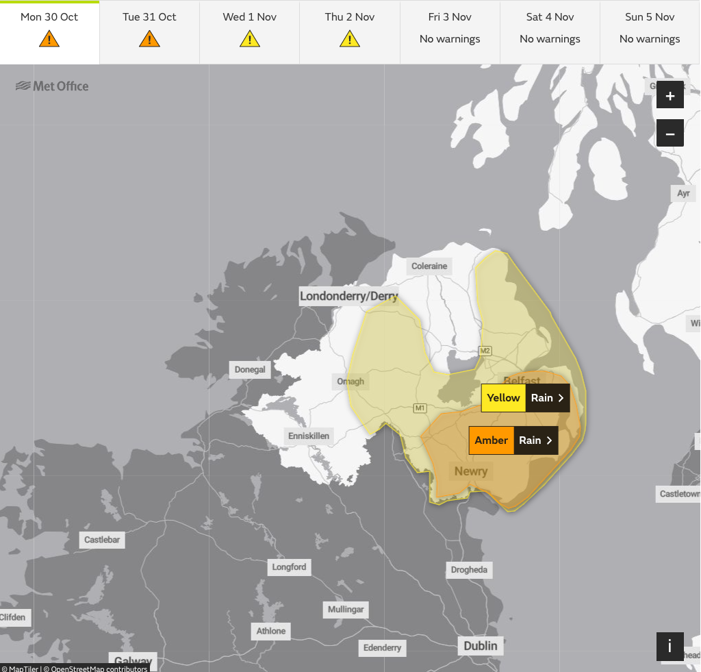
10:29 , Athena Stavrou
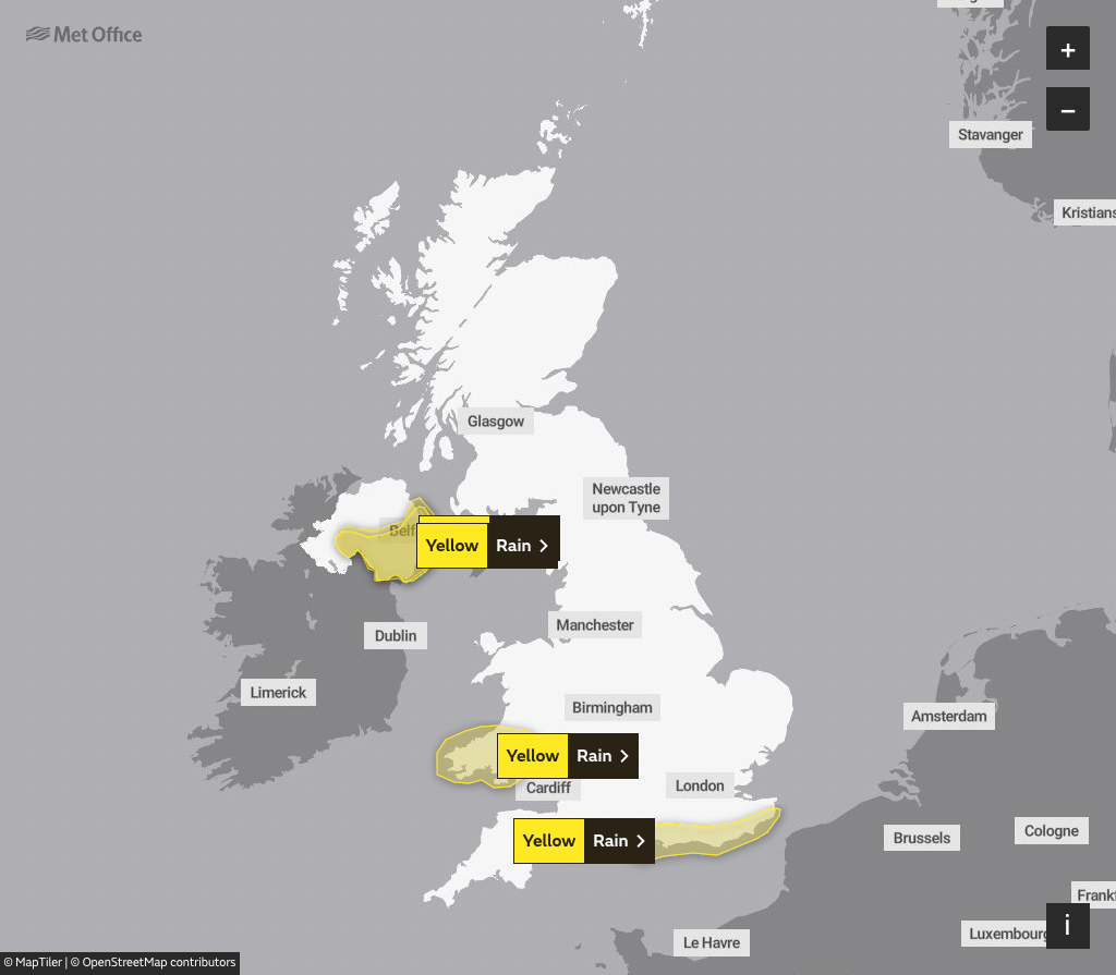
The Met Office has issued a new amber weather warning for rain today.
The warning will be in place in Northern Ireland from 9pm tonight until 9am on Tuesday and comes with a “danger to life” warning due to fast-flowing or deep floodwater.
They also say communities in the region could be “completely cut off” for “several days” by floodwater and warn of power cuts and loss of gas, water, or mobile phone services.
How bad will the weather be?
12:50 , Athena Stavrou
Storm Ciarán is set to batter the UK when it arrives on Britain’s shores on Thursday.
Met office Deputy Chief Meteorologist, Chris Almond, said “Winds associated with Storm Ciarán are likely to gust to 80mph along the south coast of England, with a small risk of somewhere exposed seeing 90mph, and winds could even gust up to 50 or 60 mph further inland.
“This deep low-pressure system will also bring heavy rain to much of the UK, but the heaviest rain is expected in southern and western areas with 20 to 25mm quite widely across the region but up to 40 to 60mm potentially over higher ground.”
For context, the entire UK usually averages 16 days of rain or snow in November, totalling 123 millimetres.
Overview of weather warnings
12:10 , Athena Stavrou
The Met Office has summarised all weather warnings in place until Thursday evening.
⚠️ A number of severe weather warnings are in place this week ahead of #StormCiarán due to arrive on Wednesday night.
Here's a summary:
🟠 An Amber warning for RAIN is in place for eastern Northern Ireland from 2100 Monday – 0900 Tuesday
⚠️ A Yellow warning for RAIN covers…— Met Office (@metoffice) October 30, 2023
Heavy rain expected as “nasty storm” builds up
11:40 , Athena Stavrou
The UK is braced for another deluge of rain over the next few days as wet and windy weather is expected to build up to a “nasty storm” later in the week.
On Monday, the worst of the weather is likely to hit the south coast of England, much of Wales and parts of Northern Ireland.
Marco Petagna, a Met Office meteorologist, said: “We’ve had various warnings in force across the UK over the last few days and there are plenty more being issued for the next couple of days.
“The main focus in the next day or two is towards the east of Scotland and north-east England where there is a yellow rain warning until 3am.
“There will be persistent rain up there and then the focus for heavy showers will be across parts of southern and south eastern England and south Wales as well parts of Northern Ireland with some heavy and sudden showers as well.”
He said that Tuesday was expected to be still unsettled but quieter before heavy winds and longer spells of rain develop on Wednesday night into Thursday as Storm Ciaran arrives.
He said: “There are possible gusts of 80 to 90 miles an hour in some exposed southern areas. It’s probably quite a nasty storm this one.”
Pictures: Weather chaos over the weekend
11:09 , Athena Stavrou
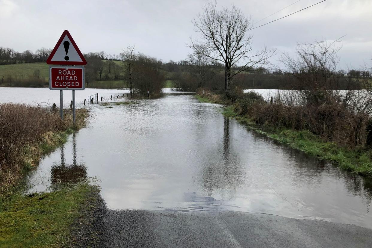
Ahead of Storm Ciarán’s arrival in the UK on Wednesday, Britons had a wet weekend with extreme flooding already being seen in some areas.

Flood warnings in place
10:12 , Athena Stavrou
Although Storm Ciarán is not set to arrive in the UK until Wednesday night, the UK is already under a staggering number of flood warnings and alerts.
In England, 69 flood warnings and 173 flood alerts are currently in place spanning almost the entirety of the country.
In Scotland, five flood warnings and five flood alerts are in place in central Scotland as well as in Edinburgh. Meanwhile, in Wales, one flood warning and 14 flood alerts have been issued in the south and southwest of the country.
UK’s five day weather forecast
10:10 , Athena Stavrou
Here’s the UK’s five day weather forecast, according to the Met Office:
Today:
Monday will be cloudy with patchy rain across eastern Scotland and northern England. Some sunshine elsewhere, but with heavy showers, some thundery, becoming more widespread from the south and west and across Northern Ireland during the afternoon.
Tonight:
Mostly dry and chilly across the north with isolated showers near coasts. Heavy showers continuing to affect southwest England, Wales and Northern Ireland. Elsewhere clear spells and patchy fog developing.
Tuesday:
Dry with sunny spells across the north. Elsewhere variable amounts of cloud with rain or showers especially across the southwest and Northern Ireland. Persistent rain arriving from the southwest later.
Outlook for Wednesday to Friday:
Wednesday will see showers or longer spells of rain moving northeast, and generally becoming windy. Storm Ciarán arriving later Wednesday bringing a spell of heavy rain and gales forces winds.
Meet the man Storm Ciarán is named after
09:38 , Athena Stavrou
The Met Office, Ireland’s Met Éirean and Royal Netherlands Meteorological Institute (KNMI) work together to compile the list before the start of the season which runs from September to August.
This year, some of them have been chosen in honour of real-life weather experts - one of them being Ciarán Fearon.
Mr Fearon is a senior engineer in the Emergency Planning Unit for Irelands Department for Infrastructure.
He tells us more about himself below:
🎥Those who work to keep people safe in times of severe weather have been recognised in the new storm names for the 2023/24 season.@Deptinfra’s Ciarán Fearon, a senior engineer in the Emergency Planning Unit has made the list.
Ciarán tells us more in the video:@metoffice pic.twitter.com/fJbQdOXPfT— Department for Infrastructure (@deptinfra) September 1, 2023
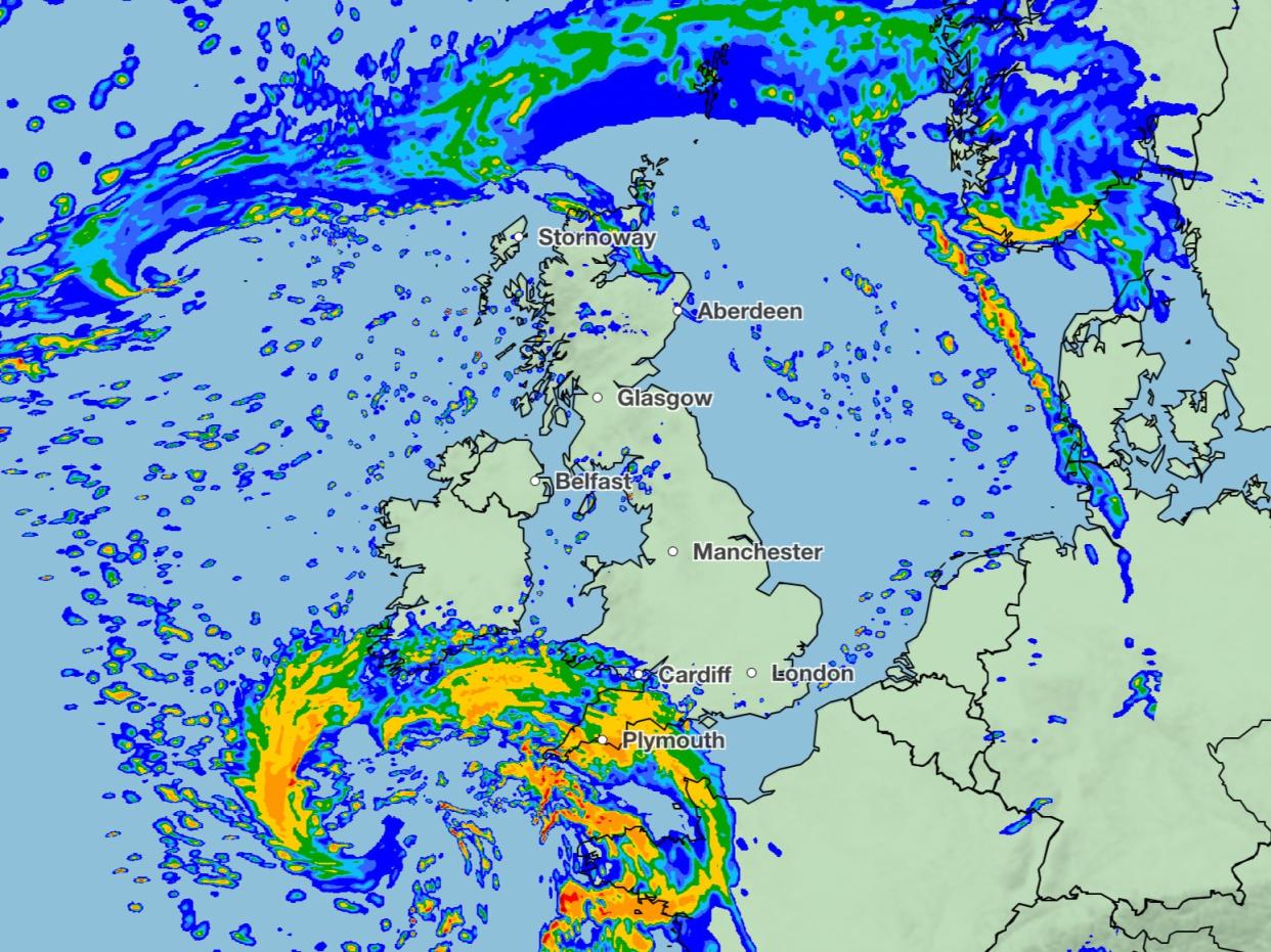
Watch: Storm Ciarán’s predicted path across the Atlantic
09:11 , Athena Stavrou
Storm Ciarán is set to arrive in Britain on Wednesday night, with it’s full effects to be seen by many Britons on Thursday.
Strong winds carried by the jet stream will cross the Atlantic this week, this area will develop into Storm Ciarán on it’s journey.
Strong winds carried by the jet stream will cross the Atlantic this week, moving from the Northeastern US to Western Europe. This area will develop into Storm #Ciarán, which will bring strong winds and rain to France and southern UK midweek. pic.twitter.com/n6EvXB0JW0
— Zoom Earth (@zoom_earth) October 29, 2023
What weather warnings are in place today?
08:40 , Athena Stavrou
Four yellow weather warnings are in place on Monday for both wind and rain.
In Wales, a yellow weather warning for rain, which began on Sunday, remains in place until 9am on Monday.
In London and southeastern England, a yellow weather warning for rain began at 12am on Monday and will remain in place until 6pm.
The Met Office warns that there is a chance of power cuts and flooding in the region.
Meanwhile, there are two yellow weather warnings in place for rain in Northern Ireland. The first began at 12am on Monday and will remain in place until noon then later in the day another yellow weather warning will come into place for rain at 4pm.
The Met Office says flooding of a few homes and businesses in the region is “likely”
Watch: Water rises above windows of London pub
08:21 , Athena Stavrou
A video from a riverside London pub shows the water level rising above the windows following a weekend of wet weather.
The pub, which is thought to be The Bull’s Head in Chiswick, posted the video to X on Sunday to show the “high tide”.
Elsewhere, a shopping centre had to be evacuated in Hastings following flooding and pictures showed flooding in a holiday park in Bognor Regis.
Today’s forecast
08:03 , Athena Stavrou
As Briton’s are expecting a wet and windy week ahead, here’s the Monday’s forecast from the Met Office.
Monday will be cloudy with patchy rain across eastern Scotland and northern England.
Some sunshine elsewhere, but with heavy showers, some thundery, becoming more widespread from the south and west and across Northern Ireland during the afternoon.
Some sunny spells to start Monday though showers affecting southern and western areas, heavy and even thundery in places ⛈️ pic.twitter.com/YPLewZEThA
— Met Office (@metoffice) October 29, 2023
Scotland rail service update
07:40 , Athena Stavrou
ScotRail services will be returning to normal on Monday following disruption during a weekend of heavy rain with weather warnings.
Some services were suspended and speed restrictions were in place while the Met Office yellow alert was in force in much of eastern and north-east Scotland. The warning expired on Sunday and ScotRail said that speed restrictions put in place across the region as a safety precaution have now been removed across most of the network.
ScotRail said that work is underway to ensure that services run as normal on Monday, though it warned passengers that there may be some remaining alternations first thing in the morning as some trains have been left out of place.

There are currently no weather warnings in place for Scotland later this week when Storm Ciarán hits, but areas in southern England have been warned by the Met Office to expect delays and cancellations to transport services.
David Simpson, ScotRail service delivery director, said: “The vast majority of services will operate as normal on Monday, and we look forward to welcoming passengers to take advantage of our off-peak all day trial.
“Customers are advised to check before travelling by visiting the ScotRail website, app, or social media channels.”
Speed restrictions will remain in place until early on Monday on the Kyle line (Inverness to Kyle of Lochalsh).
LNER said there will be no services running from Edinburgh to Aberdeen, or from Aberdeen to Edinburgh, until Monday due to the weather.
Good morning- here’s your latest update
07:25 , Athena Stavrou
Good morning and welcome to the blog. Here’s the latest weather information as the UK prepares for another week of extreme weather.
The Met Office has named the third storm of the season as it’s set to bring “strong winds and heavy rain” to the UK from Thursday.
Ciarán is due to bring gusts of 80mph winds to areas along the south coast of England, with a small risk of some more exposed areas seeing wind speeds of up to 90mph. Meanwhile, up to 60mm of rain is expected to fall in some areas.
However even before Ciarán officially hits our shores, the UK will see wet and windy weather all week. Yellow weather warnings for rain are currently in place across southeastern England, south Wales and Northern Ireland and some are set to remain in place until Thursday evening.
Storm Ciaran: How and why storms get their names
07:00 , Stuti Mishra
The UK is braced for downpours and blustering gales once again with a new storm just days after Storm Babet battered large parts of the country.
This is the third named storm of the season, hence starts with the letter C.
Here's why storms are named and the new changes the UK Met Office has made in its process for naming the storm in 2023/24 season.
Read more:

From Babet to Walid: How and why storms get their names
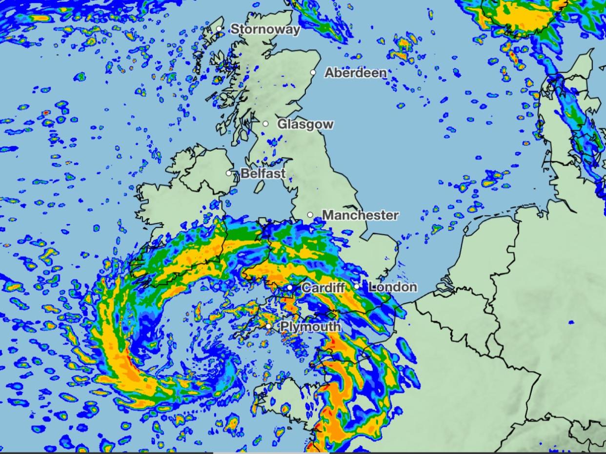
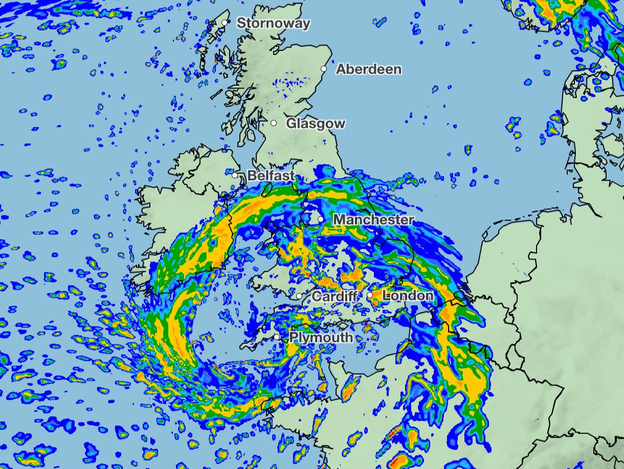
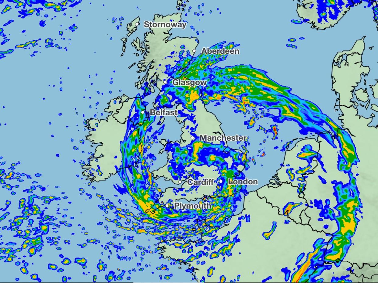
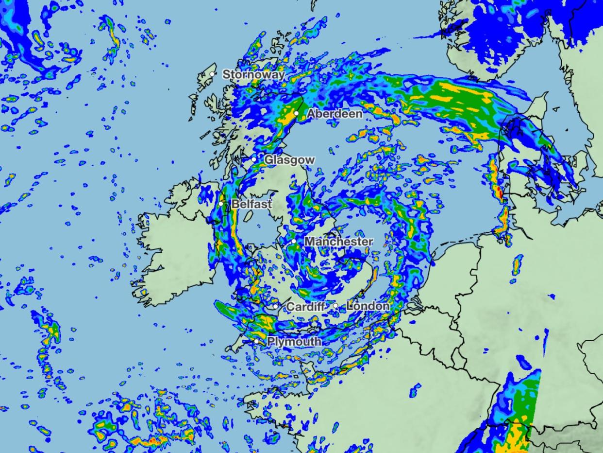
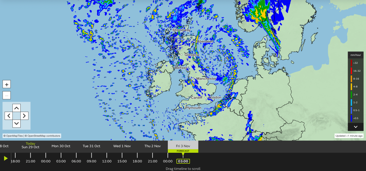
Mapped: Storm Ciarán’s path across the UK
06:00 , Athena Stavrou
Here is the predicted path Storm Ciarán is set to take as it sweeps across the UK from Wednesday night.
72 flood warnings in place ahead of Storm Ciaran
05:30 , Stuti Mishra
The Environment Agency has issued 72 flood warnings as the latest band of bad weather approaches the UK.
New storm warnings are in place from Wednesday night, and the weather front has been named Storm Ciaran.
"Heavy and persistent rain will fall on to already saturated ground bringing a risk of further impacts such as flooding in areas that are already struggling to clean up from the heavy rainfall we have seen over the last week or so," Met Office deputy chief meteorologist Chris Almond said.
"Flooding of low-lying coastal roads is also possible and people must avoid driving through flood water, as just 30cm of flowing water is enough to move your car," said Kate Marks, flood duty manager at the Environment Agency.
“People should check their flood risk, sign up for free flood warnings and keep up to date with the latest situation at https://www.gov.uk/check-if-youre-at-risk-of-flooding and follow @EnvAgency on X, formerly known as Twitter, for the latest flood updates.”
Advice for travelling in storms
05:00 , Athena Stavrou
With Storm Ciarán set to batter the UK on Thursday, here’s the Met Office’s advice for travelling in a storm:
If heavy downpours are expected, avoid starting your journey until it clears.
If you can, choose main roads, where you are less likely to be exposed to fallen branches and debris and flooding.
Use dipped headlights if visibility is seriously reduced.
If the road is flooded, turn around and find another route. The number one cause of death during flooding is driving through flood water, so the safest advice is turn around, don’t drown.
Keep an eye out for gaps between trees, buildings or bridges over a river or railway
Flood water also contains hidden hazards which can damage your car, and just an egg-cupful of water sucked into your car’s engine will lead to severe damage.
Gusts of wind can unsettle vehicles – grip your steering wheel firmly with both hands.
Remember to give vulnerable road users including cyclists, motorcyclists and pedestrians more room than usual - they are more likely to be blown around by side winds

Weather forecast for Monday
04:30 , Stuti Mishra
The week is set to start on an unsettled note with clouds and patchy rain predicted for today for large parts of Scotland and Northern England.
The Met Office forecast says "some sunshine" can be expected in the south early on but later heavy showers, some thundery, are set to become more widespread from the south and west.
Four yellow weather warnings are in place today for heavy rain covering parts of Northern Ireland and southern and southeast England.
A yellow warning which began from midnight on Monday covering Portsmouth, Brighton, Hastings and Dover is in place until 12pm.
Another yellow warning covers parts of southwest Wales and is in place until 9am on Monday.
Eastern parts of Northern Ireland are under two yellow warnings today, one in place until noon and the second starting at 4pm and extending on until Tuesday.
⚠️ Yellow weather warning issued ⚠️
Frequent heavy showers across parts of Northern Ireland
Monday 00:00 - 12:00
Latest info 👉 https://t.co/QwDLMfS950
Stay #WeatherAware pic.twitter.com/fnfqYn39xH— Met Office (@metoffice) October 29, 2023
Weather set to worsen this week
04:00 , Katy Clifton
The weather is expected to worsen as the week progresses with rain warnings in place until Wednesday.
A “deep area of low pressure” is set to arrive on Thursday which has been named by the Met Office as Storm Ciaran, threatening strong winds and heavy rain to southern parts of England and Wales.
Met Office deputy chief meteorologist Chris Almond said: “Winds associated with Storm Ciaran are likely to gust to 80mph along the south coast of England, with a small risk of somewhere exposed seeing 90mph, and winds could even gust up to 50 or 60mph further inland.
“This deep low-pressure system will also bring heavy rain to much of the UK, but the heaviest rain is expected in southern and western areas with 20 to 25mm quite widely across the region, but up to 40 to 60mm potentially over higher ground.
“Heavy and persistent rain will fall on to already saturated ground, bringing a risk of further impacts such as flooding in areas that are already struggling to clean up from the heavy rainfall we have seen over the last week or so.”
#StormCiarán has been named and is forecast to bring very strong winds and heavy rain to southern parts of the UK on Wednesday night and into Thursday
Stay #WeatherAware pic.twitter.com/wC1NxowSoW— Met Office (@metoffice) October 29, 2023
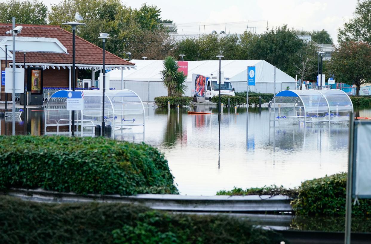
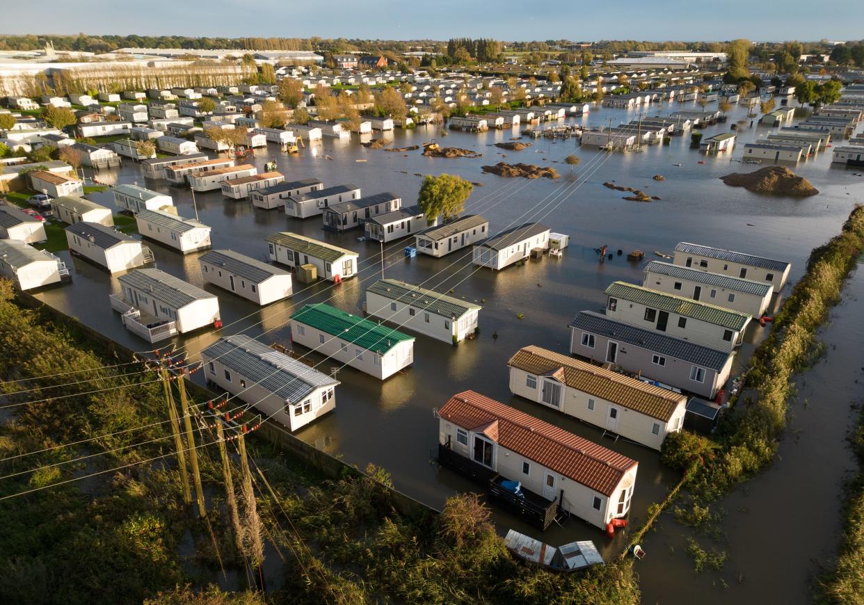
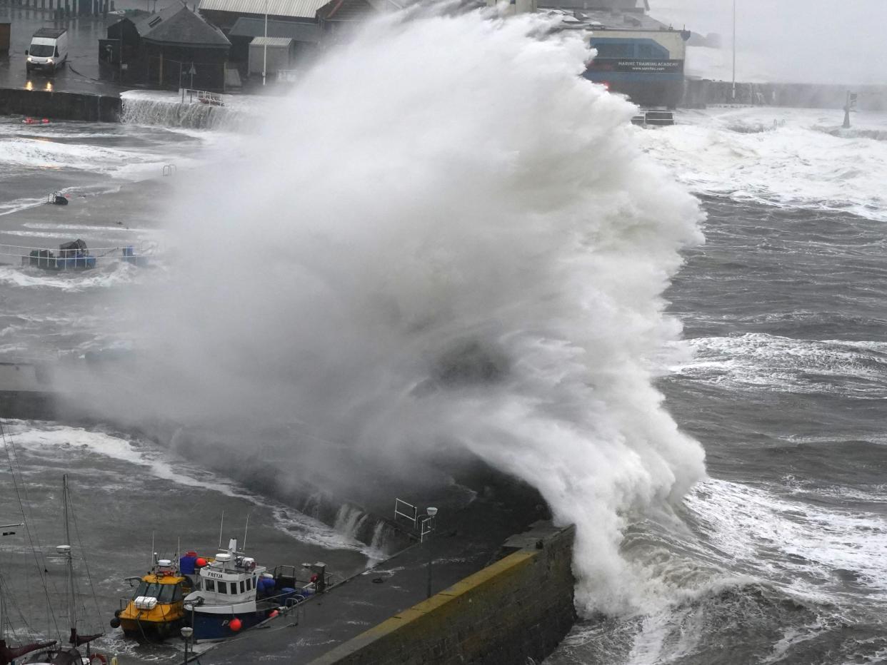
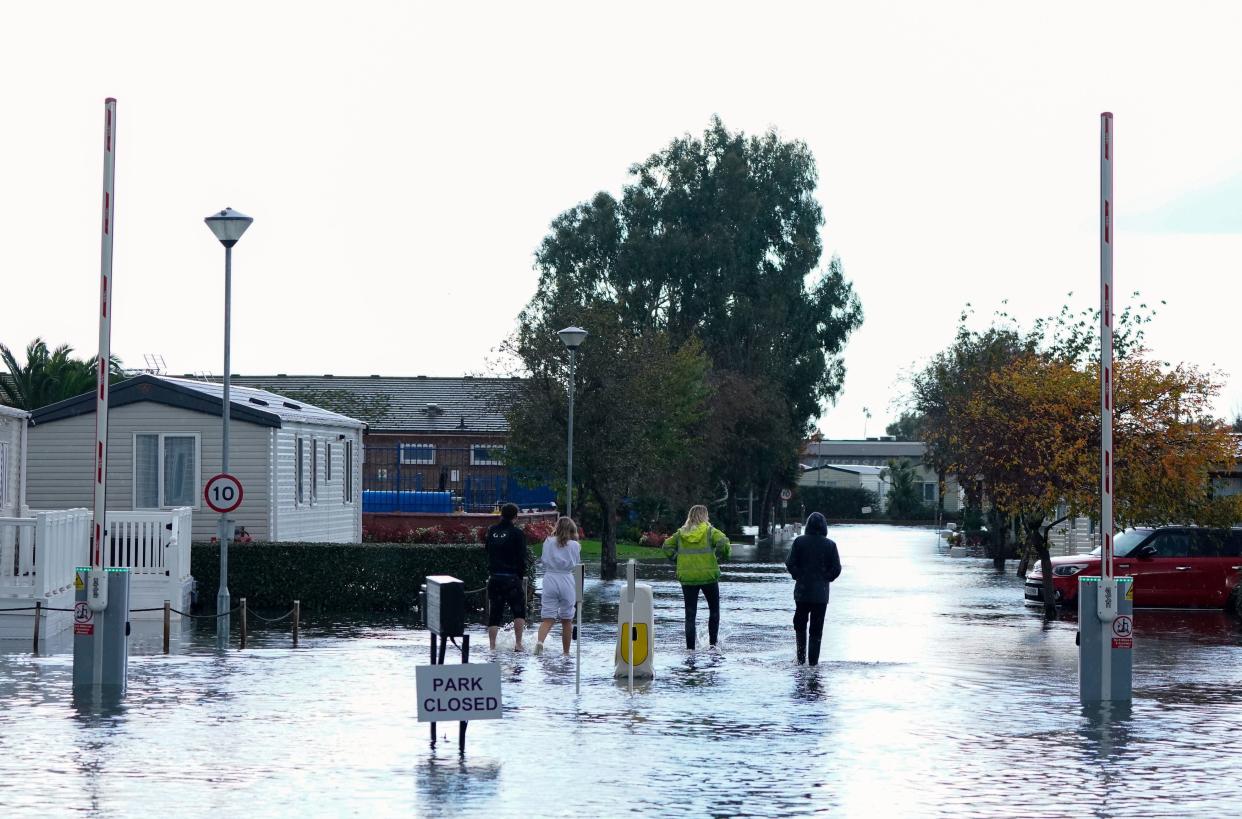
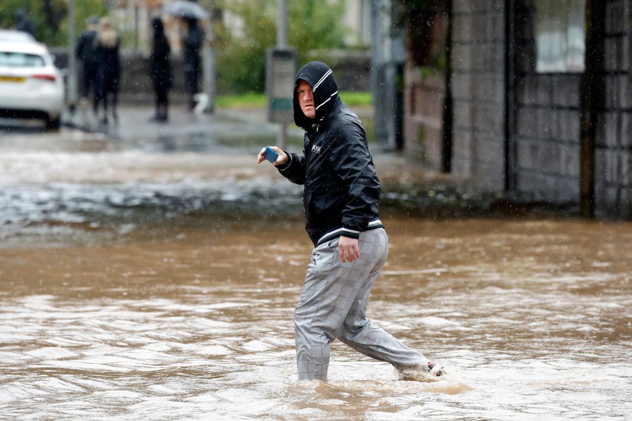
Flooding hits UK over weekend
02:00 , Katy Clifton
Flooding has been seen across Sussex over the weekend, including at the Priory Meadow Shopping Centre in Hastings which was evacuated on Saturday. Photos on social media showed floodwater coming through the entrance.
On Sunday, a caravan park in Bognor Regis was left under water, while the town’s Tesco supermarket car park also flooded.
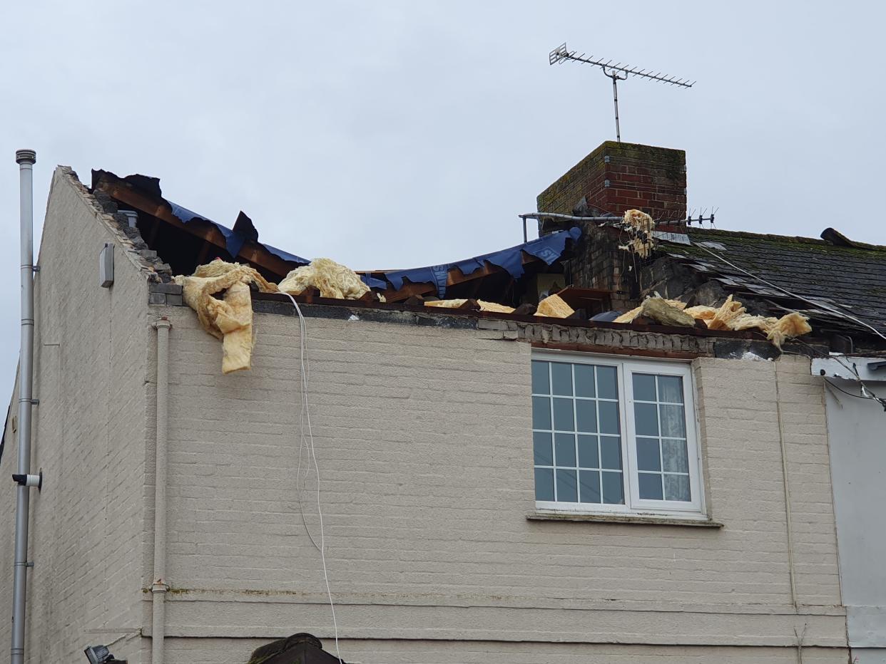
And a house had its roof ripped off in Littlehampton, West Sussex, on Saturday in what the Tornado and Storm Research Organisation (Torro) has provisionally called a tornado with a rating of T4, signifying it as being of “severe” force.
The rating suggests the tornado would have involved winds of up to 61m/s (136mph) capable of causing damage to buildings and lifting up and carrying sheds or uprooting trees.

What does a yellow weather warnings mean?
Sunday 29 October 2023 23:30 , Athena Stavrou
So far, several yellow weather warnings for wind and rain have been issued this week ahead of Storm Ciarán’s arrival.
When Storm Babet hit last week, amber and even rare red weather warnings were also issued.
Here’s what a yellow weather warning means:
“Yellow warnings can be issued for a range of weather situations,” says the Met Office.
“Many are issued when it is likely that the weather will cause some low level impacts, including some disruption to travel in a few places. Many people may be able to continue with their daily routine, but there will be some that will be directly impacted and so it is important to assess if you could be affected.“
Other yellow warnings are issued when the weather could bring much more severe impacts to the majority of people but the certainty of those impacts occurring is much lower. It is important to read the content of yellow warnings to determine which weather situation is being covered by the yellow warning.”
Full report: Met Office issues fresh weather warnings as storm officially named
Sunday 29 October 2023 21:30 , Athena Stavrou
The Met Office has issued fresh weather warnings heading into next week as Storm Ciarán is set to sweep across the UK later this week.
The forecasters have said severe weather warnings are to be expected until Thursday, before the latest named storm is due to arrive.
Ciarán is due to bring 80mph gusts to areas along the south coast of England, with a small risk of some more exposed areas seeing wind speeds of up to 90mph. Meanwhile, up to 60mm of rain is expected to fall in some areas.
Read more:

Met Office issues fresh weather warnings as storm officially named
What is extreme weather?
Sunday 29 October 2023 19:30 , Athena Stavrou
Storm Ciarán is the latest extreme weather event the UK has seen in recent weeks. The third named storm of this year’s season comes after areas across Scotland and north-east England were battered with the worst of Storm Babet, which caused serious damage and several deaths when it hit last week.
From flooding to heatwaves, wildfires to droughts, Earth’s weather cycles have shown signs of becoming increasingly more erratic, severe and prolonged, and though there is no blanket explanation for this change in weather patterns, human-induced global warming is a major underlying factor.
The Independent looks at extreme weather below:
Met Office advice for staying safe in a storm
Sunday 29 October 2023 18:30 , Athena Stavrou
With Storm Ciarán set to batter the UK on Thursday, here’s the Met Office’s advice for staying safe in a storm:
Stay indoors as much as possible
If you do go out, try not to walk or shelter close to buildings and trees
Keep away from the sheltered side of boundary walls and fences - if these structures fail, they will collapse on this side
Do not go outside to repair damage while the storm is in progress
If possible, enter and leave your house through doors in the sheltered side, closing them behind you
Open internal doors only as needed, and close them behind you
Take care when driving on exposed routes such as bridges, or high open roads, delay your journey or find alternative routes if possible
Slow down and be aware of side winds, particular care should be taken if you are towing or are a high sided vehicle
Do not drive unless your journey is really necessary
UK’s five day weather forecast
Sunday 29 October 2023 17:30 , Athena Stavrou
This Evening and Tonight:
Rain will affect eastern Scotland and northeast England overnight, heavy and persistent at first. Elsewhere there will be clear spells and showers, the showers heaviest near to southern and western coasts of England and Wales. Patchy frost in the north.
Monday:
Monday will be cloudy with patchy rain across eastern Scotland and northern England. Some sunshine elsewhere, but with heavy showers, some thundery, becoming more widespread from the south and west.
Outlook for Tuesday to Thursday:
Tuesday and Wednesday will see showers or longer spells of rain moving north and east across all parts, and generally becoming windy. Storm Ciarán arriving from the southwest later Wednesday.
In pictures: Britons brave the heavy rain
Sunday 29 October 2023 15:57 , Athena Stavrou
Here are the latest pictures of the weather from Sunday as the UK prepares for the arrival of Storm Ciarán.


Further weather warning issued for Northern Ireland
Sunday 29 October 2023 15:30 , Athena Stavrou
The Met Office has issued a new weather warning for Northern Ireland, ahead of Storm Ciarán’s arrival on Thursday.
The yellow weather warning for heavy showers will come into place at 4pm on Monday and remain until Tuesday at 3pm.
⚠️ Yellow weather warning issued ⚠️
Heavy showers across parts of Northern Ireland
Monday 1600 – Tuesday 1500
Latest info 👉 https://t.co/QwDLMfS950
Stay #WeatherAware pic.twitter.com/vHeESJndok— Met Office (@metoffice) October 29, 2023
Staggering number of flood warnings in place
Sunday 29 October 2023 15:00 , Athena Stavrou
As the week ahead is set to bring further rain to the UK, Britons are to expect more heavy flooding.
Met office Deputy Chief Meteorologist, Chris Almond, said: “Heavy and persistent rain will fall onto already saturated ground bringing a risk of further impacts such as flooding in areas that are already struggling to clean up from the heavy rainfall we have seen over the last week or so.”
The Environment agency currently has a staggering 71 flood warnings in place across England and a further 172 flood alerts. In Scotland 18 flood warnings and 11 flood alerts are currently in place while in Wales there are six warnings and 17 alerts.

From Ciarán to Walid: How and why storms get their names
Sunday 29 October 2023 14:30 , Athena Stavrou
For the 2023/24 season, the way the Met Office and Irish service Met Éireann names storms has changed.
Previously, names were drawn from a shortlist of favourites chosen by the public.
But now, the storms will be named after those working to protect people from severe weather around the UK.
Along with Met Eireann in Ireland and KNMI, the Dutch weather service, meteorologists name storms when they are expected to have a “medium” or “high” impact on people in the UK, Ireland or the Netherlands.
This helps communicate the seriousness of a storm to the public and helps people recognise what steps to take, the Met Office said.
The three organisations work together to compile the list of names before the following season, which runs from September to August.
How to prepare for a storm
Sunday 29 October 2023 14:00 , Athena Stavrou
Here is the Met Office’s advice on what to do in advance to prepare for a storm:
Secure loose objects such as ladders, garden furniture or anything else that could be blown into windows and other glazing and break them
Close and securely fasten doors and windows, particularly those on the windward side of the house, and especially large doors such as those on garages
Park vehicles in a garage, if available; otherwise keep them clear of buildings, trees, walls and fences
Close and secure loft trapdoors with bolts, particularly if roof pitch is less than 30°
If the house is fitted with storm shutters over the windows then ensure that these are closed and fastened
If chimney stacks are tall and in poor condition, move beds away from areas directly below them
New weather warnings issued for Storm Ciarán
Sunday 29 October 2023 13:35 , Athena Stavrou
The Met Office has issued fresh weather warnings due to begin on Wednesday evening as the UK braces itself for Storm Ciarán.
The warnings for wind and rain are due to affect the entirety of southern England, London, south Wales and the West Midlands.
The yellow warning for rain is set to be in effect from 6pm on Wednesday to midnight on Thursday, while the yellow warning for wind will come into place at midnight on Wednesday and remain in place until 6pm on Thursday morning.
⚠️ Yellow weather warning issued ⚠️
Heavy rain associated with #StormCiarán with further disruption likely
Wednesday 1800 – Thursday 2359
Latest info 👉 https://t.co/QwDLMfS950
Stay #WeatherAware⚠️ pic.twitter.com/VdOox8IcD9— Met Office (@metoffice) October 29, 2023
Where will be affected?
Sunday 29 October 2023 13:15 , Athena Stavrou
It’s unclear where exactly Storm Ciarán will hit, but the Met Office say southern England and Wales will primarily be affected.
The forecasters added that the coming week will continue to bring unsettling weather for “much of the UK”.
A number of Severe Weather Warnings for rain are also expected to be issued for Monday, Tuesday and Wednesday before the storm officially arrives on Thursday.

How bad will the weather be?
Sunday 29 October 2023 13:03 , Athena Stavrou
Storm Ciarán is set to batter the UK when it arrives on Britain’s shores on Thursday.
Met office Deputy Chief Meteorologist, Chris Almond, said “Winds associated with Storm Ciarán are likely to gust to 80mph along the south coast of England, with a small risk of somewhere exposed seeing 90mph, and winds could even gust up to 50 or 60 mph further inland.
“This deep low-pressure system will also bring heavy rain to much of the UK, but the heaviest rain is expected in southern and western areas with 20 to 25mm quite widely across the region but up to 40 to 60mm potentially over higher ground.”
For context, the entire UK usually averages 16 days of rain or snow in November, totalling 123 millimetres.
Met Office name latest storm set to bring 90mph winds to the UK this week
Sunday 29 October 2023 12:59 , Athena Stavrou
The Met Office has named the third storm of the season as it’s set to bring 90mph winds to the UK from Thursday.
The forecaster said Storm Ciarán is set to bring “strong winds and heavy rain” as it sweeps across the UK next week.
It comes after areas across Scotland and north-east England were battered with the worst of Storm Babet, which caused serious damage and several deaths when it hit last week.
Met office Deputy Chief Meteorologist, Chris Almond, said: “Heavy and persistent rain will fall onto already saturated ground bringing a risk of further impacts such as flooding in areas that are already struggling to clean up from the heavy rainfall we have seen over the last week or so.”
The Environment agency currently has a staggering 71 flood warnings in place across England and a further 172 flood alerts. Meanwhile in Scotland, 18 flood warnings and 11 flood alerts are currently in place.
#StormCiarán has been named and is forecast to bring very strong winds and heavy rain to southern parts of the UK on Wednesday night and into Thursday
Stay #WeatherAware pic.twitter.com/wC1NxowSoW— Met Office (@metoffice) October 29, 2023
Investment urged in ‘dangerously overstretched’ fire service to aid floods work
Sunday 29 October 2023 16:34 , Athena Stavrou
Following the devastating impact of Storm Babet on the UK last week, firefighter leaders warned urgent investment is needed to ensure the “dangerously overstretched” fire service is prepared for flooding in future.
The Fire Brigades Union (FBU) claimed that in areas of Nottinghamshire the fire service did not have enough resources to respond to all emergency calls.
Read more:

Investment urged in ‘dangerously overstretched’ fire service to aid floods work
