Weather: Tornadoes suspected in Warren, Butler counties; flooding, power outages reported
Update 10:05 a.m.: The Milford Community Fire Department, Milford Police Department, and mutual aid departments were dispatched to the Target area at 6:23 a.m. Wednesday to rescue a family that had awoken to their tent surrounded by flood water.
According to a Facebook post from the fire department, the tent was located along the East Fork of the Little Miami River. Dispatchers have safely removed the family from the area. Two people were taken to Bethesda North Hospital for treatment of minor injuries and cold exposure.
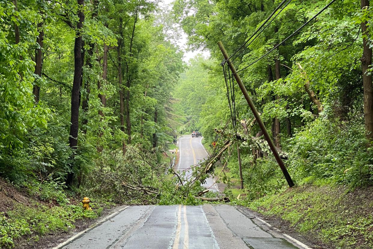
Bender Road in Delhi Township is currently closed due to debris in the roadways from Tuesday's storms. Township crews are currently working to clear the debris and hope to reopen the road later today, per a Facebook comment from the Delhi Township Administration.
Update 9:41 a.m.: Power outage reports are rising again following severe thunderstorms that swept through the area Tuesday night. Approximately 884 outages had been reported in Greater Cincinnati as of 9:41 a.m. on Wednesday.
Update 9:05 a.m.: Approximately 879 outage reports had been made in Greater Cincinnati as of 9:05 a.m. on Wednesday, per Duke Energy's outage map.
Update 8:35 a.m.: The National Weather Service office in Wilmington will conduct storm surveys today for the following areas: Warren, Butler, Darke, and Mercer counties in Ohio and Franklin County in Indiana. The surveys are in relation to the severe thunderstorms that moved through the area on Tuesday.
Power outages have also been reported in Greater Cincinnati but were down to around 869 as of Wednesday morning, according to Duke Energy. At the peak of the outages, about 4,000 customers lost power.
Previous reporting: Severe weather that could spawn tornadoes is possible again Wednesday, even as the National Weather Service plans storm surveys to assess the damage from Tuesday's storms.
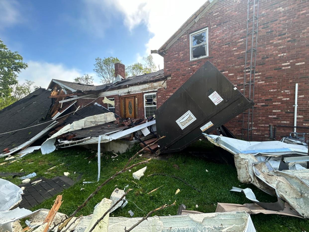
According to Fox19, tornadoes may have touched down in Warren and Butler counties in southwest Ohio and Franklin County in Indiana.
Jim Lott, a meteorologist with the National Weather Service in Wilmington, told Fox19 that radar detected rotation in Reily Township in Butler County, the Morrow area of Warren County, and near Brookville in southeastern Indiana.
Lott said the NWS received reports of downed trees and wires in these areas and roofs being ripped off in Franklin County. Power outages were reported in Greater Cincinnati but were down to just over 1,000 Wednesday morning, according to Duke Energy. At the peak of the outages, about 4,000 customers lost power.
Forecast: Severe weather brings threat of tornadoes again Wednesday. See what to expect and when
The weather service said it plans to conduct storm surveys on Wednesday. However, efforts may be limited due to severe weather that is slated to return Wednesday night. If you have observed any weather-related damage, please report it to the National Weather Service via severe weather reporting methods or by calling 937-383-0031.
According to a hazardous weather outlook, severe thunderstorms will be possible again late today into the evening. Damaging winds and large hail will be the primary threats, with a few tornadoes possible.
A flood warning remains in effect until 10 a.m. Wednesday in the following counties: Dearborn, Ohio, and Ripley in Indiana; Boone, Campbell, and Kenton in Northern Kentucky; and Brown, Clermont, Hamilton, and Highland in Ohio.
According to the report, flooding of rivers, creeks, streams, and other low-lying and flood-prone locations is imminent or occurring. Numerous roads remain closed due to flooding.
As of 4:04 a.m., between one and three inches of rain had fallen, and there had been several reports of high water on roads. Cincinnati firefighter Kirsten Worth even rescued one person from a car submerged in water on Yoast Avenue in North Fairmount, per the Cincinnati Fire Department.
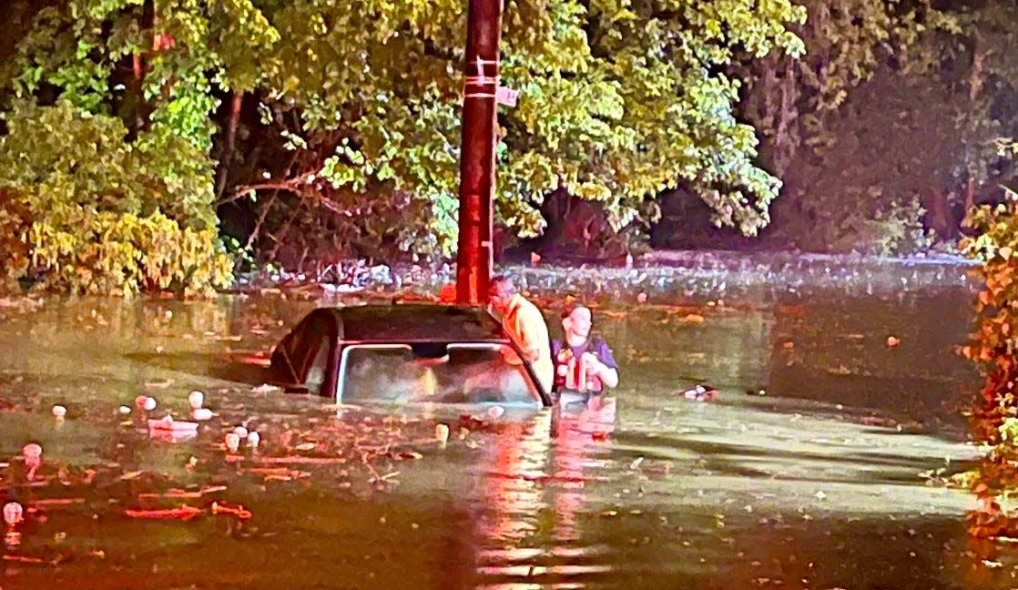
High water was also reported overnight at Beechmont Avenue on Columbia Parkway, according to Cincinnati police, and at least one motorist got stuck in floodwater. Both roads are clear and open, Cincinnati police reported Wednesday morning.
Other locations that may experience flooding include:
Cincinnati
Covington
Florence
Independence
Norwood
Erlanger
Fort Thomas
Newport
Loveland
Madeira
Edgewood
Alexandria
Elsmere
Cheviot
Fort Mitchell
Villa Hills
Highland Heights
Milford
Taylor Mill
Bellevue
FF Kirsten Worth rescues one occupant from a car on Yoast Ave in North Fairmount overnight. Our firefighters have responded to dozens of
storm related calls tonight, fortunately only minor injuries have been reported so far. pic.twitter.com/VPEIapsimn— Cincy Fire & EMS (@CincyFireEMS) May 8, 2024
The NWS advises drivers to turn around when encountering flooded roads because most flood deaths occur in vehicles. Be especially cautious at night, as it may be harder to recognize the dangers of flooding.
Detailed Forecast
Severe thunderstorms will be possible again later this afternoon and evening with the highest threats along and south of the Ohio River. pic.twitter.com/TtVWUbMKTB
— NWS Wilmington OH (@NWSILN) May 8, 2024
Wednesday: There is a chance of showers and thunderstorms, mainly after 5 p.m. There are Increasing clouds, with a high near 85. The southwest wind is 3 to 6 mph. The chance of precipitation is 30%. New rainfall amounts will be less than a tenth of an inch, except higher amounts are possible in thunderstorms.
Wednesday night: Showers and thunderstorms are likely, followed by showers and possibly a thunderstorm after 2 a.m. The low will be around 64. The south wind will be around 6 mph. The chance of precipitation is 90%. New rainfall will be between a tenth and a quarter of an inch, except higher amounts are possible in thunderstorms.
Thursday: Showers and possibly a thunderstorm, mainly before 2 p.m., then a chance of showers and thunderstorms after 2 p.m. High near 76. West wind 5 to 13 mph. The chance of precipitation is 80%. New rainfall amounts will be less than a tenth of an inch, except higher amounts are possible in thunderstorms.
Thursday night: Showers and thunderstorms are possible before 8 p.m. The sky is mostly cloudy, with a low of around 50. The wind is north at 9 to 14 mph. The chance of precipitation is 30%. New rainfall amounts to less than a tenth of an inch, except higher amounts are possible in thunderstorms.
Friday: There is a slight chance of showers after 2 p.m. It will be partly sunny, with a high near 67. The wind will be north at 7 to 11 mph. The chance of precipitation is 20%.
Friday Night: Partly cloudy, with a low around 49.
Saturday: There is a chance of showers, followed by showers likely and possibly a thunderstorm after 2 p.m. It will be mostly sunny, with a high near 69. The chance of precipitation is 60%.
Sunday: Sunny, with a high near 73.
Monday: There is a chance of showers. It will be mostly sunny, with a high near 78. The chance of precipitation is 30%.
Tuesday: There is a chance of showers and thunderstorms. It will be mostly sunny, with a high near 80. The chance of precipitation is 40%.
Source: National Weather Service, Wilmington.
This article originally appeared on Cincinnati Enquirer: Weather: Tornadoes suspected in Warren, Butler counties. What to know
