Savannah weather live updates: Coastal Georgia under tornado watch Tuesday afternoon
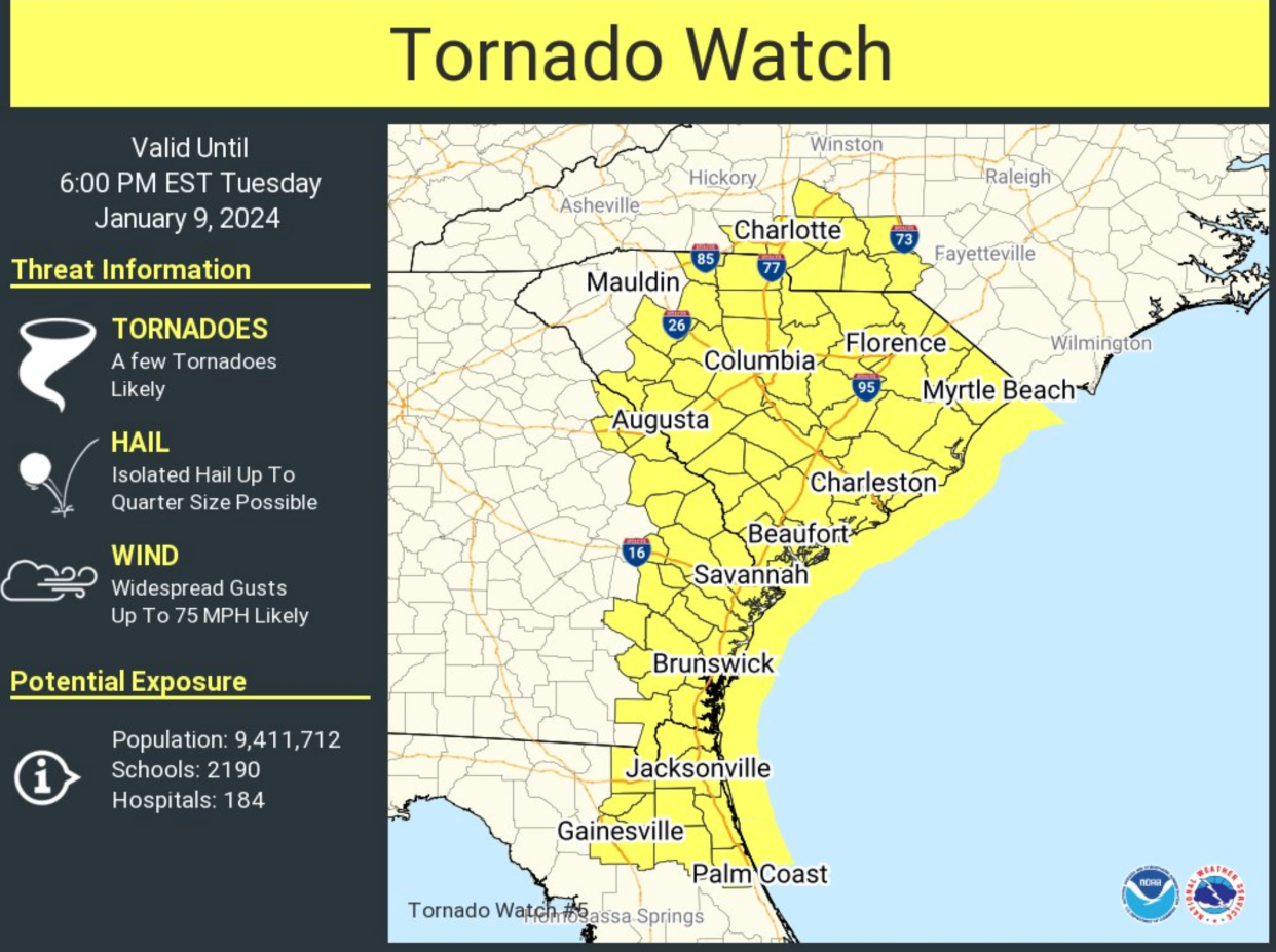
The National Weather Service has issued a Tornado Watch until 6 p.m. Tuesday for most of the Georgia coast.
The affected area includes Chatham, Bryan, Effingham and Liberty counties; and Beaufort and Jasper counties in South Carolina.
"Winds will continue to strengthen across the coastal counties through the afternoon," the weather service's Charleston office cautioned late Tuesday morning. "Trees have been reported blown down in many areas since sunrise and additional wind damage is likely."
As of noon, wind gusts of 30 mph had been recorded at U.S. Hunter Army Airfield. Top winds could double that Tuesday afternoon. The worst conditions – including "strong winds, possible severe thunderstorms and tornadoes, and dangerous beach and marine conditions" – are expected between noon and 8 p.m., the weather service said.
As much as 1.5 inches of rain is possible as a line of storms rolls into the area from the east.
Live weather updates around the state: Tornado warnings issued for southeast Georgia counties
Follow belong for storm updates — including any road closures, power outages, etc. — from the Savannah Morning News team.
Georgia Ports Authority Statement | 1:57 p.m.
After high winds toppled a shipping container at the Port of Savannah, trapping a person inside, the Georgia Ports Authority issued the following statement:
Garden City Terminal will close empty container pickup and drop-off service from noon to 1800 hrs Tuesday, January 9, due to wind conditions forecast for this afternoon. Truck gates remain open - business as usual - for full container pickup and drop-off.
City of Savannah weather update | 1:54 p.m.
The Dean Forest Landfill will close at 2 p.m. today due to increasing winds. All Tuesday sanitation routes were completed as scheduled. Residents are reminded to please secure refuse and recycling carts, and any yard debris.
Effingham County weather update | 1:30 p.m.
Residents in Effingham County are feeling the effects of severe weather as downed trees and power outages can be seen throughout the county. According to the Effingham County Sheriff’s Office, lights are out on Highway 21 in Rincon and power lines are down on Highway 21 near Eugene Gnann Road in Springfield. Downed trees can be spotted near Fourth Street and McCall Road in Rincon.
Reporter Latrice Williams contributed this update.
Wind warning, surf advisory for Savannah area
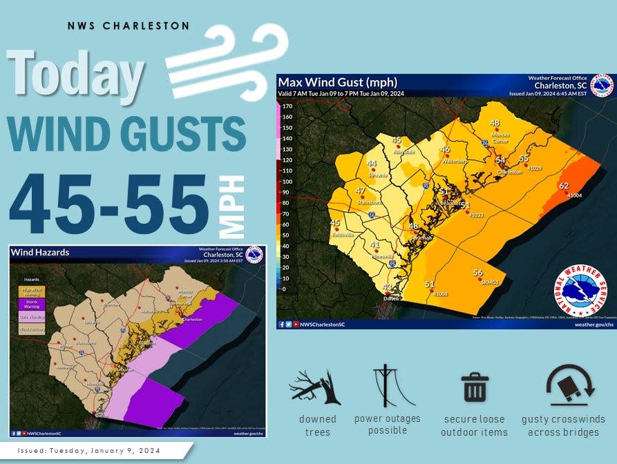
The National Weather service issued a High Wind Warning from 10 a.m. to 10 p.m. Tuesday for the coast of Chatham County northward to Charleston. South winds of 30-40 mph and gusts up to 69 mph are expected.
"Winds could be even higher on elevated surfaces such as bridges and overpasses, making travel difficult," the weather service warned.
Live weather updates: Tornado warnings issued in southwest Georgia
A High Surf Advisory also is in effect for Georgia beaches until 7 p.m. Tuesday. Waves as high as 6 feet are expected near shore, leading to "dangerous swimming and surfing conditions and localized beach erosion," according to the weather service.
Temperatures in Savannah climbed from 53 degrees at 6 p.m. Monday to 68 degrees at 7 a.m. Tuesday as the weather system blew into the area.
Statewide power outages in Georgia
As of noon, nearly 64,000 power outages had been reported in Georgia, according to poweroutage.us. About 100,000 customers in Florida were in the dark.
Georgia Power offered the following tips for dealing with storm-related situations.
Never touch any downed or low hanging line. Always assume power lines are energized. Report the location of any downed or low hanging line to Georgia Power. You can also contact local authorities or 911.
Never try to make your own electrical repairs to power equipment.
Never pull tree limbs off power lines because they could be energized.
Never go into areas with debris or downed trees. Dangerous power lines may be buried in the wreckage.
Avoid stepping in puddles and standing water after a storm. They may be touching hidden, downed power lines and be electrified.
Never walk into areas where crews are at work. If you're driving near work crews, obey road signs and proceed cautiously.
Conditions are expected to improve overnight, with mostly sunny skies Wednesday and high temperatures in the mid-50s. Blustery conditions will linger, however, with winds of 10-14 mph and gusts as high as 23 mph, according to the forecast Tuesday.
John Deem cover climate change and the environment on the Georgia coast. He can be reached at jdeem@gannett.com.
This article originally appeared on Savannah Morning News: Weather updates Savannah, Ga.: Radar, weather warnings, tornado activity
