Alert | Freezing rain forecast closes I-84 in advance of storm. Tri-Cities bracing for snow
Days of snow and freezing rain forecast for the Tri-Cities may mean nightmarish commutes this week, if the forecast holds.
Students should keep an eye out for school delays or closures and click here to find our updated list.
An ice storm warning is issued for the Columbia River Gorge, including on Interstate 84 between Hood River, Ore., and Cascade Locks, Ore., from Tuesday afternoon through mid-morning Wednesday.
The interstate closed between Troutdale near Portland and Hood River about 3 p.m. Tuesday in anticipation of the storm.
“Ice accumulation creates some of the most treacherous driving conditions, and the interstate is being closed to keep everyone safe,” the Oregon Department of Transportation said as it announced the closure.
Travelers who were on the road at 4 p.m. were advised to stop where they were rather than driving to closure points where parking may be more difficult to find.
Solid ice is challenging to combat, ODOT said. Liquid deicer and salt are diluted and sand is quickly buried.
The Columbia Generating Station, the Northwest’s only nuclear power reactor, is under a “no touch” request to keep the Richland reactor operating as electricity demand has soared to a new record level.
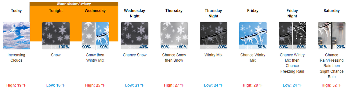
The National Weather Service has issued a winter storm watch from 4 p.m. Tuesday until 7 p.m. Wednesday for southcentral Washington, including from Yakima to Walla Walla and from Wenatchee south to Pendleton, Ore.
For the Tri-Cities it forecasts a 100% chance of snow Tuesday night mostly before 2 a.m. Tri-Cities residents could wake up to 1 to 3 inches of snow, it said.
The chance of more snow Wednesday before 2 p.m. is 90%, turning to freezing rain later in the afternoon. Little or no ice accumulation is expected and less than 1 inch of new snow.
Thursday an 80% chance of snow is forecast after 5 p.m., again with less than 1 inch of new snow.
Thursday evening snow could change to a wintry mix with snow, sleet and freezing rain possible into the night until about 2 a.m. New snow and sleet accumulation of about an inch is forecast.
Friday morning could be another challenge for commuters with a 50% chance of sleet and freezing rain until 2 p.m., then a chance of light snow. More freezing rain is forecast that night into Saturday morning.
Warming weather should mean any precipitation through the weekend will fall as rain.
Finley Middle School students had a day off on Tuesday due to a broken pipe because of the cold snap.
But now temperatures are expected to warm from lows of 2 and 3 degrees in Tri-Cities.
Lows should be in the 20s Wednesday night through Saturday night, warming to a possible low of 31 by Sunday night.
Highs that have been in the teens on recent days should climb to the 20s for Wednesday through Thursday and then could reach 32 on Saturday, according to the weather service.
For mid-January in the Tri-Cities highs normally area bout 41 and lows 28.
Power demand high
The Bonneville Power Administration set a power load record of 11,396 megawatts on Saturday at 11 a.m. as the demand for electricity soared during cold weather across the Northwest.
It is a record for what BPA calls its modern era, or the years since the last aluminum smelter shut down. The previous “modern” record of 11,068 megawatts was set in December 2022, with the all-time peak load when still supplying aluminum smelters was 11,930 megawatts.
The Bonneville Power Administration asked Energy Northwest to use “no touch” protocols for its nuclear power reactor starting Wednesday, Jan. 10, as a precaution against any reduction of power production.
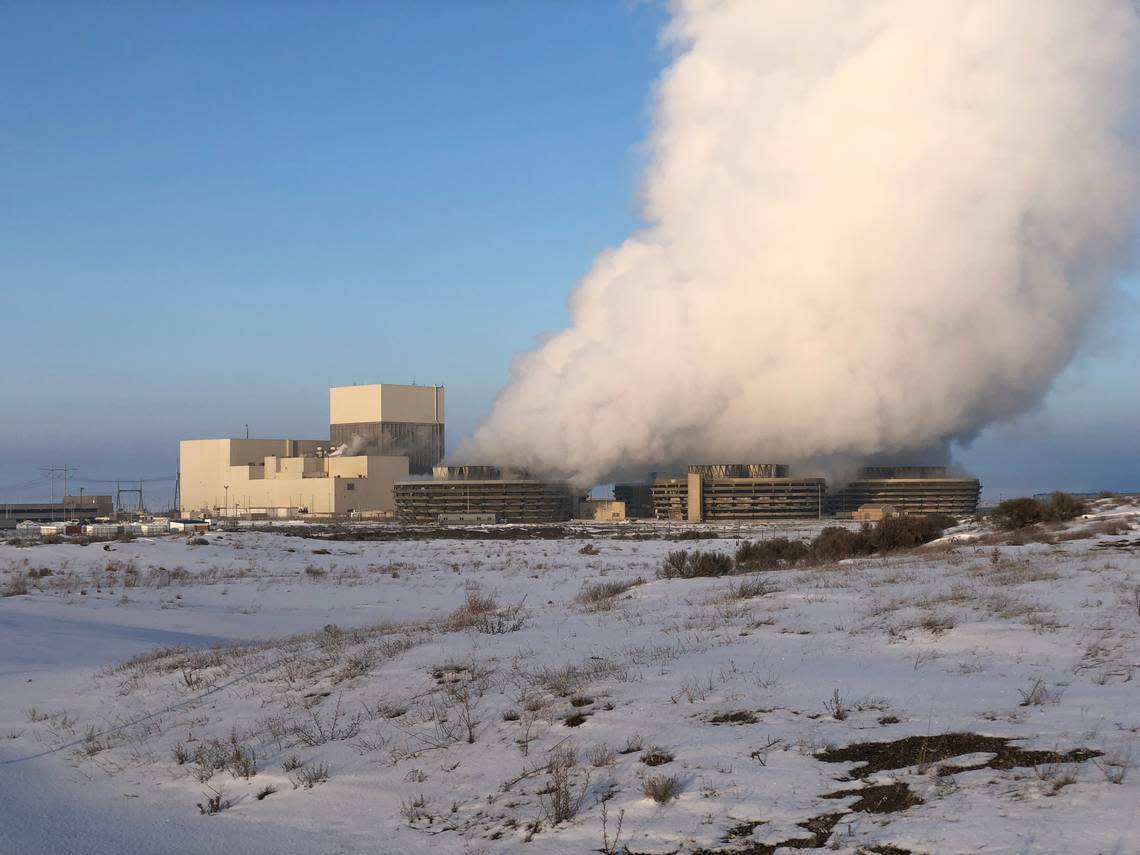
Under “no touch” protocols, Energy Northwest evaluates and restricts any work activity that could pose a risk to generation. The plant is currently at 100% power and has been online for 211 days.
It produces about 10% of Washington state’s power annually.
Grant PUD on Monday afternoon asked its customers to reduce electricity use for the next 36 hours to avoid the potential for local and regional outages until temperatures warm.
“Frigid temperatures throughout Grant County and the Pacific Northwest this past week have pushed energy use to record levels, strained many regional electric grids, and put a heavy draw on our region’s capacity to generate electricity,” it told customers Monday.
Cutting back is especially important during hours of peak energy use from 5-9 a.m. and 3-8 p.m., it said.
It asked that thermostats be set to 68 degrees.
Customers could avoid using large electric appliances, such as ovens, dryers and dishwashers during peak times. They also are asked to avoid using large amounts of hot water.
Temperatures should be dialed down in swimming pools and outdoor hot tubs, it said.
While customers should not reduce energy use to a point it jeopardizes their health or the integrity of houses or other structures, “any reasonable way you can safely reduce energy use will help keep electricity available to everyone,” the PUD said.
Electric utilities serving the Tri-Cities area have not requested customers cut back on electricity use. But Benton PUD this fall started a new residential billing structure to allow people to save money if they shift some electric use to off peak hours.
Customers could be hit with a surcharge based on their highest use of electricity each month from 6-9 a.m. and 5-8 p.m. Overall rates for electricity were dropped to offset the high use surcharge.
WA, OR travel forecast
Tri-Cities residents may want to rethink any road travel plans until at least the weekend.
A winter storm warning with heavy snow is issued for the Cascade Mountains of Washington, including Interstate 90 at Snoqualmie Pass from Tuesday afternoon through Thursday afternoon.
Wednesday 8 to 12 inches of new snow is possible with another 4 to 8 inches Wednesday night, 3 to 7 inches Thursday and 3 to 5 inches Thursday night.
Freezing rain and snow are forecast for Friday.
Tri-Cities travelers heading east through Oregon on I-84 can expect rain and snow through Friday, according to the weather service.
The pass near Meacham, Ore., 30 miles east of Pendelton, is among areas under a winter storm warning from Tuesday afternoon through Thursday afternoon.
The largest snow accumulation is forecast for Tuesday night at 1 to 3 inches there. But a rain and snow mixture may make roads icy at least through Thursday.
More rain and snow are forecast for Friday, before precipitation turns to rain Friday night through the weekend.
