Watching from space, satellites collect evidence of war crimes
Few developments in Ukraine have escaped the all-seeing eyes of satellites.
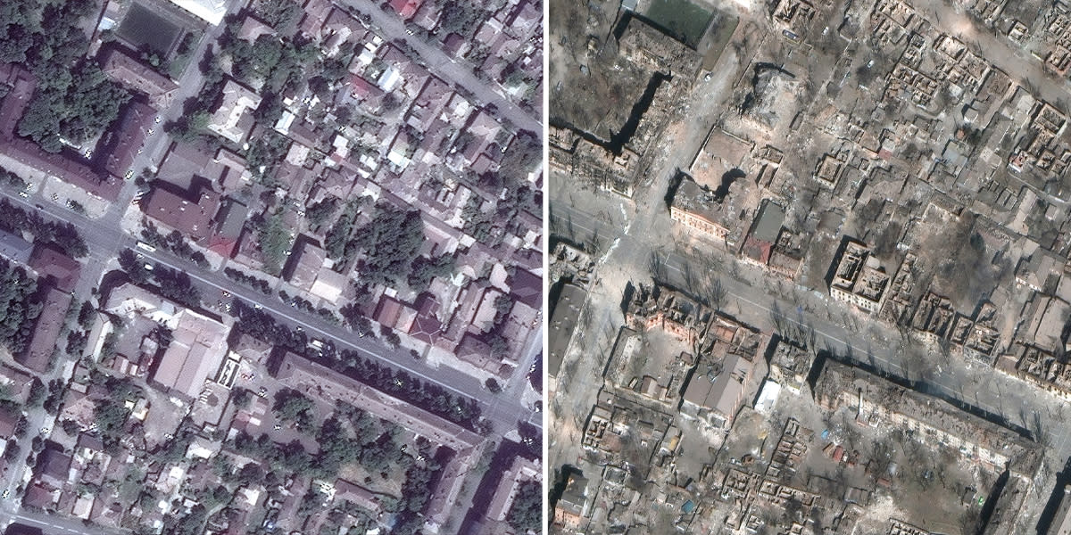
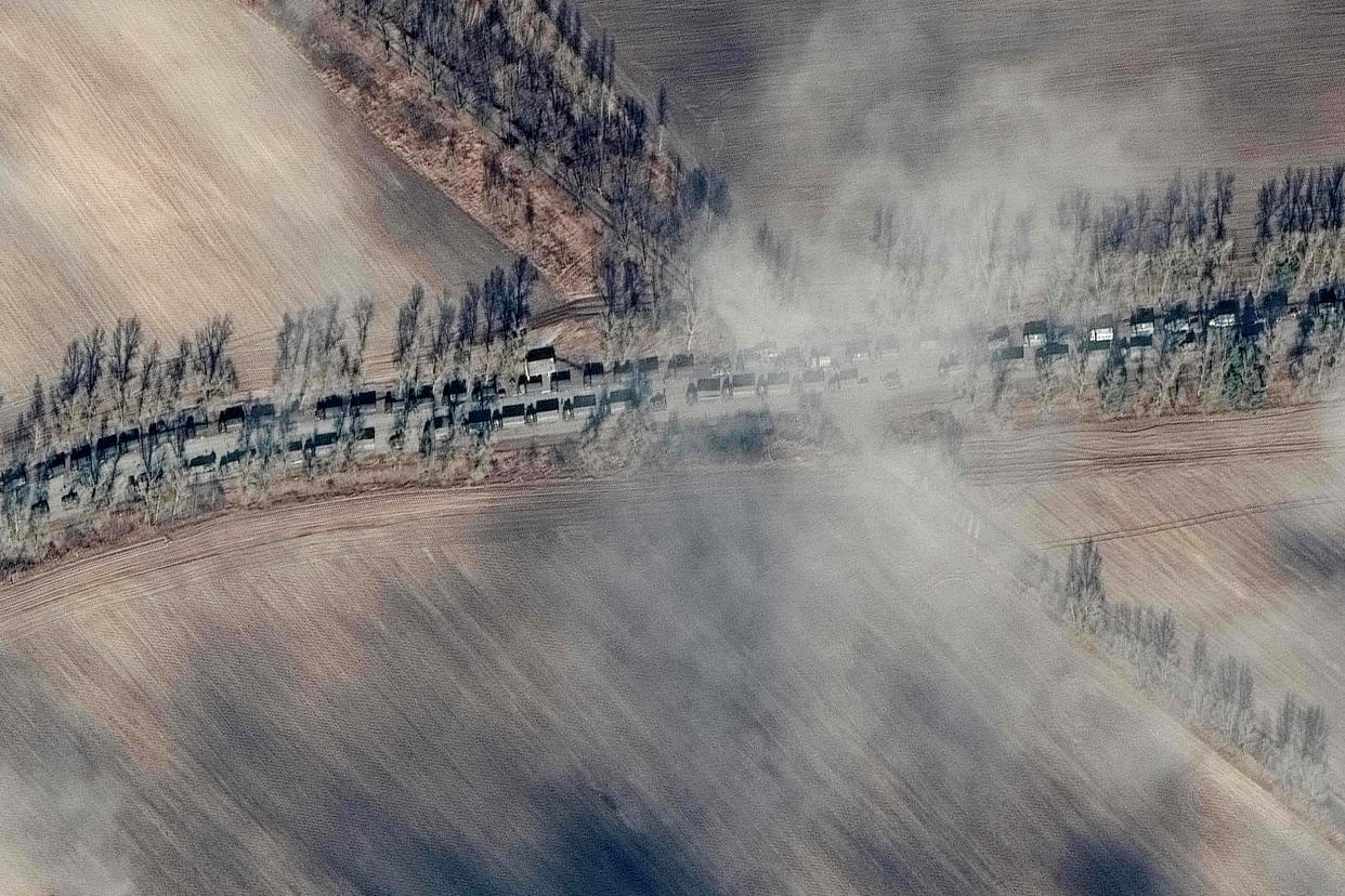
From their orbital perches, Earth-watching satellites have followed the movement of troops around the country, zeroing in on strikes in contested areas and witnessing the aftermath of attacks.
Now, these “eyes in the sky” are gathering images in greater quantities and at higher resolutions than ever before, collecting what could end up as crucial pieces of evidence in investigations into potential war crimes committed by Russia since its military assault began on Feb. 24.
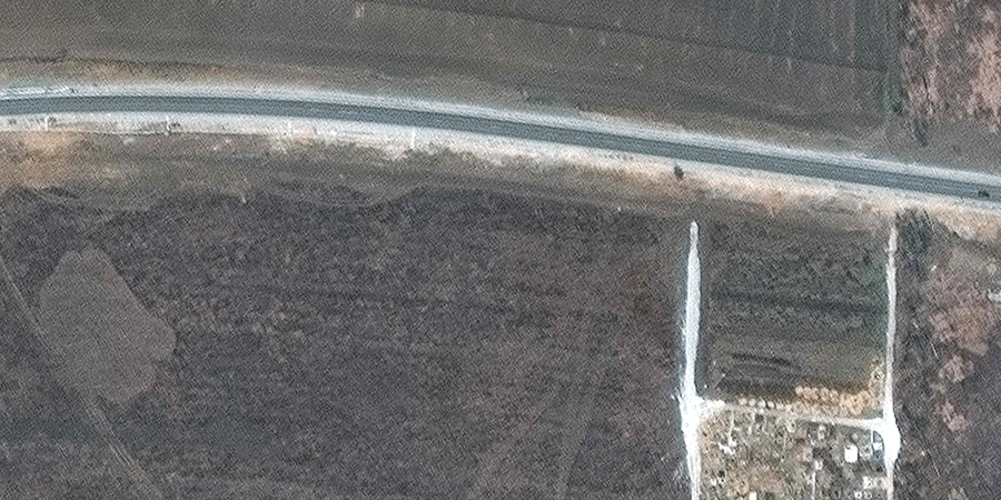
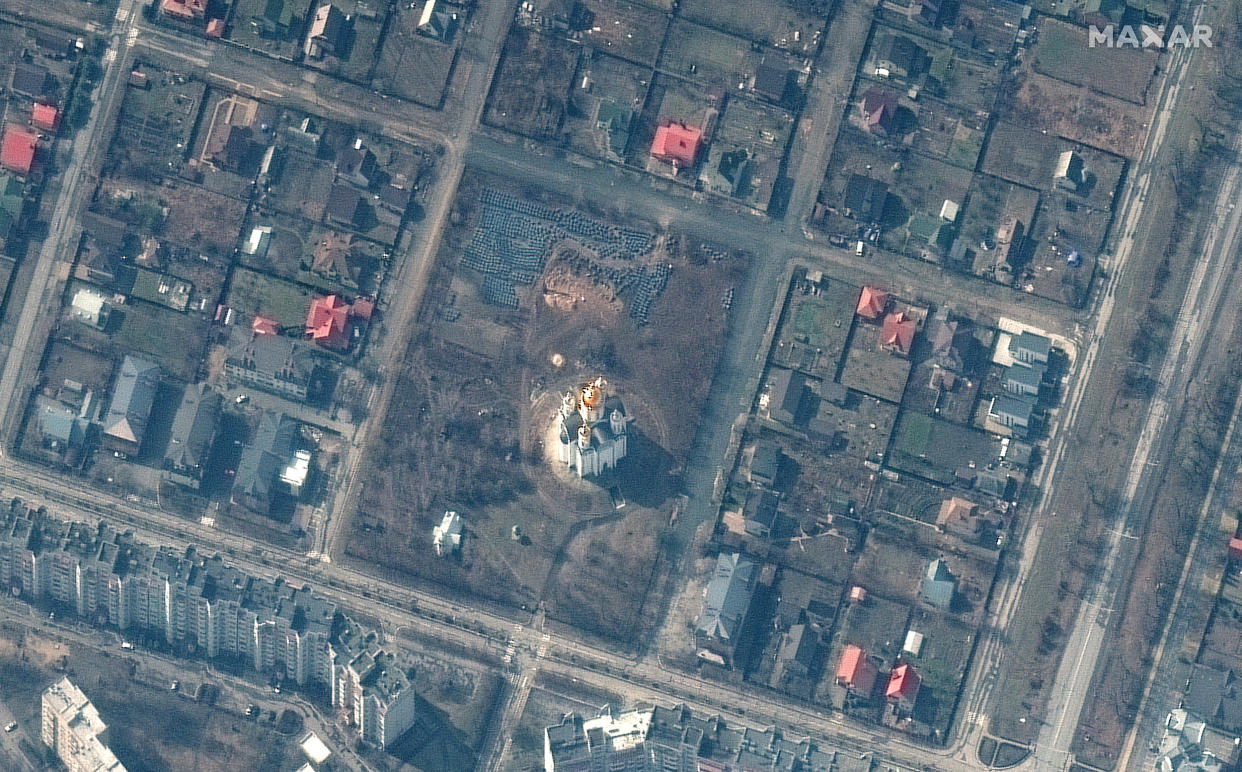
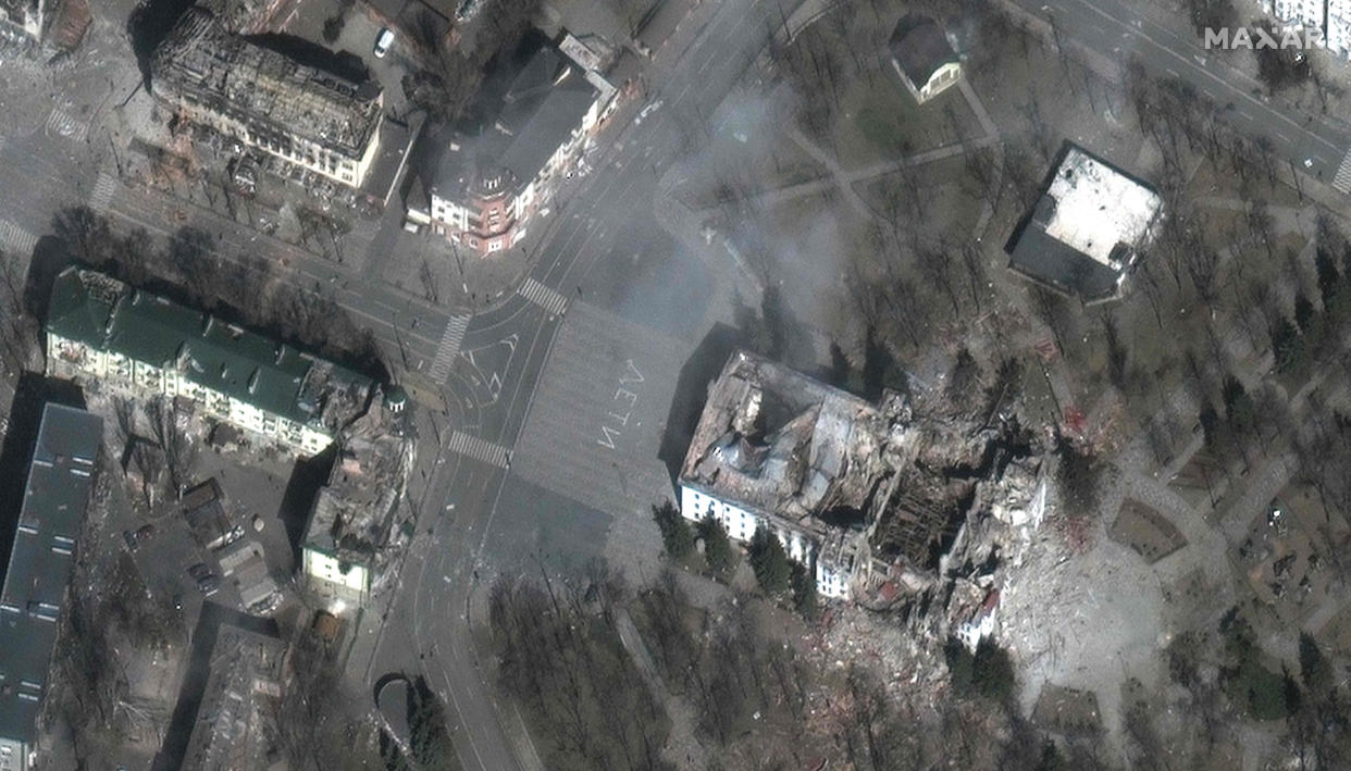
Among the atrocities already documented from space: A 45-foot trench dug near a gold-domed church in the Kyiv suburb of Bucha, where a mass grave was later uncovered; overhead views of a bombed-out theater in the southern port city of Mariupol, where hundreds of women and children were sheltering from airstrikes; and most recently, a series of holes that appeared outside Mariupol that Ukrainian officials said were a mass grave.
Experts say satellite imagery, together with on-the-ground photos and eyewitness accounts, could be vital in providing evidence to be able to take those responsible for Russia’s alleged war crimes to court.
“The nice thing about satellite imagery is that it has a very high level of veracity to it, and veracity is key to any war crimes investigation,” said Scott Herman, CEO of Cognitive Space, a Texas-based satellite software company. “It provides what we call ground truth, which is the root of what actually happened.”
Last month, the United Nations established an inquiry into potential violations of human rights by the Russian forces in Ukraine. The International Criminal Court (ICC) has also launched its own investigation, along with Ukraine’s prosecutor general’s office. As of last week, more than 2,899 civilians had been killed in the conflict, according to an estimate by the United Nations.
Building a case
Satellite images have been used in the past as evidence in international courtrooms.
One of the milestone cases came in 2016, when the ICC prosecuted a defendant for a war crime involving intentionally directing attacks against historic monuments and buildings in Mali.
A several-hundred-page “geolocation report” that took satellite imagery and compared it to all the photos and videos that were taken by war-crimes investigators was introduced into evidence as part of the case, said international lawyer Alexa Koenig, executive director at the UC Berkeley School of Law’s Human Rights Center.
“Instead of just being a discrete piece of satellite imagery, it was really a mechanism for kind of helping all of the visual imagery be brought together to tell a story about the actual case,” she said.
But while satellite images can be “extremely important” to successfully prosecuting cases, they should be looked at alongside other pieces of evidence to make sure the prosecutors are not jumping to conclusions beyond reasonable doubt, said Matthew Gillett, an international lawyer and lecturer at the U.K.’s University of Essex, who specializes in the verification of digital evidence.
“There are a lot of questions that an image won’t necessarily be able to answer,” Gillett said.
It can also be difficult to prosecute war crimes even with what seems like plenty of evidence, Herman, from Cognitive Space, said.
“The bar is really, really high,” he said. “There’s a lot of nuance around the legal definitions required to prosecute, and what may seem like in-your-face evidence that something clearly evil happened — in reality there’s still a long way to go from taking that and turning it into a prosecutable war crime.”
From a legal perspective, what’s unique about satellite imagery as evidence, Gillett said, is that unlike people’s memories, which can fade, or witnesses who can disappear, they are static and don’t change over time, once safely stored. In fact, as more and more evidence emerges, satellite images can help shed more light onto what happened.
Views from space
Maxar Technologies, a U.S. defense contractor headquartered in Colorado, has provided some of the most extensive publicly available satellite images of the conflict in Ukraine since it started. The company has its own news bureau that works alongside media organizations to analyze and disseminate reams of data beamed from space.
Stephen Wood, senior director of the Maxar News Bureau, said his team’s work can play a critical role in documenting the war’s development and capturing the truth about the invasion as it happens.
“We see this as an important part of what we can do to help with transparency and fight back against disinformation,” Wood said.
Maxar’s satellites have been used for decades to monitor natural disasters, global events and other geopolitical situations in the past, but Wood said the quality — and quantity — of satellite imagery focused on the Russia-Ukraine conflict has been unlike anything he has experienced in his 22 years with the company.
Wood said advancements in satellite technologies over the past decade mean they can now spot events on the ground in stunning detail. Maxar’s four satellites can snap photos at 30-centimeter (12-inch) resolution, he said, which is sharp enough to make out human activities from space.
“We’re able to see very small features, like the gun on an artillery piece,” Wood said. “We can see the windshield on a car, or we can identify the type of tank.”
The ability of satellites to operate at such high resolutions will likely make these images more important for potential war crimes investigations than in any previous conflict, Herman said, adding that “the more you can make out on the ground, the better you can interpret what’s actually happening.”
Maxar is not the only company focusing its orbital gaze on Ukraine. Other satellite firms,
including Planet and BlackSky, have been gathering and analyzing data throughout the conflict.
These simultaneous efforts mean there are more eyes on Ukraine at any given time, and any point of interest can be monitored with greater frequency during each orbital pass. This can provide analysts with the data necessary to piece together an accurate timeline of events or substantiate claims made by both Russians and Ukrainians.
Koenig said there has been a growing interest from companies like Maxar and Planet in contributing their satellite imagery for justice and accountability purposes in recent years.
“It used to be so expensive that it was very rare that human rights investigators or war crime investigators could actually get the kinds of images they needed,” she added. “And now I think it’s a growing partnership and willingness to make sure that this kind of imagery actually comes into justice efforts.”
Planet’s imagery, for instance, provided evidence of Russia’s attack on Ukraine’s Chuhuiv Air Base, spotted Russian trenches built near Chernobyl and documented attacks on civilian buildings in the besieged city of Mariupol.
Photos of dead bodies in the streets of Bucha taken by Maxar satellites were also used to disprove claims by Russia that civilians in the city were killed after Russian troops had already left the area.
Patrick O’Neil, chief innovation officer at BlackSky, said satellite intelligence is a crucial way to increase transparency and visibility in these types of fast-moving situations. The resulting data can help officials understand not just details of the war itself but also how to respond to subsequent humanitarian crises.
“We have been supporting government and humanitarian activities in Ukraine since early in the conflict and we believe the world needs geospatial intelligence now more than ever,” O’Neil said in a statement provided to NBC News.
In the 1990s, Herman took part in legal investigations in Sarajevo in the aftermath of the Bosnian War. He and his colleagues were tasked with collecting evidence of war crimes, but Herman said it was difficult work and investigators were often limited by what they could find months or even years after the fighting had taken place.
Now, with satellite companies collecting publicly available data on a daily basis, investigators can corroborate key events quickly and follow their progression in greater detail than ever before, Herman said.
“It’s a completely different ballgame in terms of war crimes investigations,” he said.
Clouds and sunlight
The sheer volume of satellite data coming out of Ukraine could also pose a challenge for investigators and prosecutors alike, Gillett added — in terms of man hours, expertise and impartiality required to wade through potentially millions of aerial images to provide an assessment that a court would be comfortable relying on.
“The challenge now becomes less about finding that one piece of content because it may not exist, but finding that one piece of content in all of that noise,” Koenig said.
Logistically, monitoring ground activities with satellites also comes with its share of challenges. There are often lags between observational windows, for instance, when satellites are not passing over Ukraine. Even when the cameras are pointed at the country, satellite operators need to know where to look and what to focus on, Wood said. Bad weather, especially at this time of year, can also obstruct views from space, he added.
“Springtime rains and heavy cloud cover have really covered a lot of Ukraine, so we’re not able to get as good a look at it right now,” Wood said.
Ultimately, the “eyes in the sky” are making it harder for warring parties to effectively conceal what’s happening on the ground, experts said.
“Sunlight is the best disinfectant for wrongdoers and human rights abuses in general,” Gillett said. “The availability of objectively verifiable images makes it much more difficult to hide serious crimes and widespread human rights abuses.”
