Warmer temperatures in Michigan mean perennial plants may survive winter, USDA map shows
A map relied upon by many of America's 80 million gardeners and growers just got its first update in more than a decade. The U.S. Department of Agriculture's Plant Hardiness Zone Map shows warmer conditions throughout much of the country, including the Great Lakes region — which may mean that perennial plants that at one time wouldn't have survived a Michigan winter may now do so.
A joint project of USDA's Agricultural Research Service and Oregon State University's PRISM Climate Group, the maps are a type of plant selection guide going back nearly a century in various iterations. The latest map updates one released in 2012.
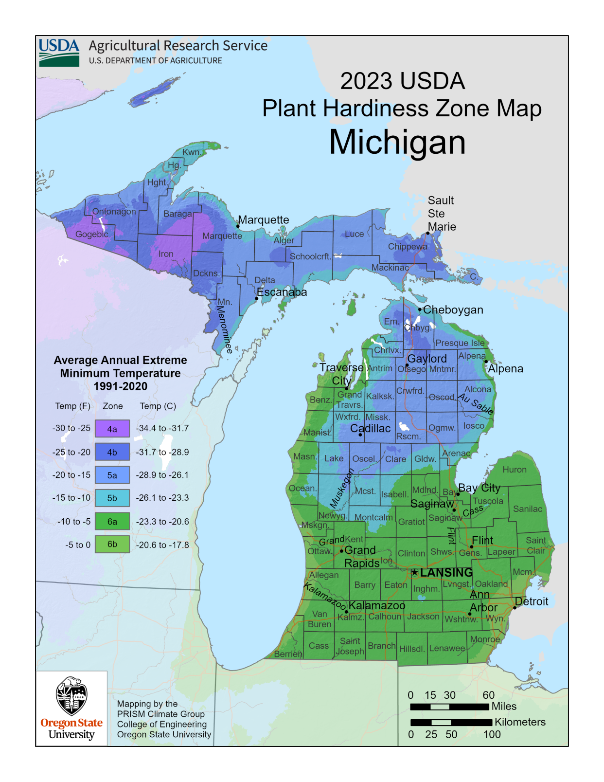
The maps look at the extreme lowest minimum temperature experienced in a particular location over a 30-year timeframe, with the new map going based on 1991 to 2020. The maps are divided into zones in gradations of 10 degrees Fahrenheit, and then further subdivided into two half-zones of 5 degrees each. For example, Zone 6 includes average lowest annual winter temperatures of between -10 degrees F and 0 degrees F, broken into Zone 6a from -10 to -5 degrees, and Zone 6b from -5 degrees to 0.
Will this plant survive the winter?
"So when a gardener or even a farmer looks at plants they want to have in the ground over winter, perennial plants, these perennial plants are tagged with a hardiness zone designation. It will say, 'This plant is hardy to Zone 7a, or 8b or 4a,'" said Christopher Daly, a professor at Oregon State and founding director of its PRISM Climate Group.
"You look to see what zone you are in and see whether that plant is suitable to your location, if you can expect it to survive the extreme winter cold that might occur."
The update shows average minimum temperatures across the contiguous U.S. up 2.5 degrees Fahrenheit over the 2012 map, with the Eastern U.S., Central Plains and Midwest experiencing higher temperature increases than some other regions.
It's not necessarily a conclusive result of human-driven climate change — but climate change as a factor can't be dismissed either, Daly said.
"We know for a fact that average temperatures are rising due to climate change; there's no doubt about that," he said.
"Over the long term, this should cause plant hardiness zones to gradually creep northward. But because the plant hardiness statistic is this annual extreme minimum temperature — one number per year — it's highly volatile from year to year, and subject to the magnitude and timing of the weather event that produced that coldest temperature, wherever you might be."
Better information — improved methods and more weather stations providing data over the 2012 maps — may also account for some of the map-to-map changes being seen, Daly said.
'Plants that used to not work in our area now work'
Detroit's zone didn't change from the 2012 map, remaining Zone 6b, an extreme minimum winter temperature of -5 degrees to 0. But the 6b zone expanded farther north into the Detroit suburbs, Daly said.
Some areas of western Michigan bumped up a zone, but that is likely due to better accounting for the warming effect of Lake Michigan, he said. In northern Lower Michigan and the Upper Peninsula, some areas increased two half-zones.
More: Climate change is already hurting Michigan's cherry, apple crops — and it could get worse
The updated map confirms the on-the-ground experience of Michigan gardeners, said Nancy Ryan, president of Michigan Garden Clubs Inc., a 94-year-old organization with 132 member clubs throughout the state.
"We've all been saying the same thing: Plants that used to not work in our area now work because it's warmer," she said.
"I know of gardeners who can get their winter-hardy vegetables, cover them and literally now get them through the winter, which was unheard of in the past."
The hardiness zone map is also used to help set crop insurance standards, and by scientists as a data layer in many research models, as they look at things such as the spread of invasive weeds and insects.
Daly issued a word of caution. "If your area has moved up a half-zone, don't go out and pull up all of your stuff in your garden and buy new plants," he said.
More: As climate change alters Michigan forests, some work to see if and how the woods can adapt
"But you might say, 'Maybe I should look for those warmer areas in my garden — protected areas, or a nice, sunny, south-facing wall. Maybe I could try to grow a plant that's hardy to this new half-zone there and see how it goes.'"
Daly's other caution: The map tells you how cold it has been, not how cold it might be.
"All it takes is one cold snap to knock out your perennials that you paid a lot of money for," he said. "So you need to be aware and protect those plants if you think you've got a big cold wave coming."
The clickable map can be found at https://planthardiness.ars.usda.gov.
Contact Keith Matheny: kmatheny@freepress.com.
This article originally appeared on Detroit Free Press: Updated USDA plant hardiness map: Perennials may survive in Michigan
