Summer is here, and so is the forecast: Get the scoop from AccuWeather experts


Summer has arrived in the Northern Hemisphere following the June solstice, and it could be hotter than last summer in many big cities across the central and eastern United States.
Early spells of summerlike warmth provided previews of the season across much of the country, including in New York City, where the mercury hit 90 degrees on back-to-back days in mid-April, and in Texas, where temperatures set all-time high temperature records on the final days of spring.
One month, in particular, stands out to AccuWeather's team of long-range meteorologists, led by Senior Meteorologist Paul Pastelok.
"Our team has concerns about July, which can feature many high-impact events like severe weather, wildfires, significant drought and flooding," Pastelok said.
Will it be a hot summer? When will be the best time to head to the beach? Will lawnmowers get a workout this summer? AccuWeather has the answers to these questions and more in the exclusive U.S. summer forecast.
A two-sided summer is in the cards for most of the Midwest and Northeast this year, with the weather patterns expected to completely flip part of the way through the season.
Similar to last year, the Midwest and Northeast could experience a wet and stormy start to the summer before drier conditions take over in August. As a result, people may have to mow their lawns on a more frequent basis during the first half of the season compared to the second half.
August could be the best month to visit the beach, go camping or partake in other outdoor events due to the downturn in rain and storms. However, the month will not be completely dry, so it will still be important to check the free AccuWeather app before spending a day outdoors.
 |
Children play in "Appearing Rooms," one of the installations that are part of the "Please Touch the Art" exhibition by Danish artist Jeppe Hein at the Brooklyn Bridge Park Tuesday, July 21, 2015, in New York. (AP Photo/Mary Altaffer) |
Energy demand could also rise during the second half of the summer as the heat turns up. A few heat waves will be possible from late July through August from the mid-Atlantic through the Midwest.
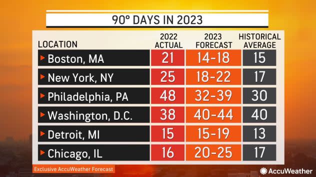
The mercury is forecast to reach 90 F more times in 2023 than in 2022 in several major cities, including Chicago, where the temperature hit the 90-degree mark 16 times in 2022, right around the historical average. AccuWeather meteorologists say there will be about 20-25 days of 90-degree heat in the Windy City this year.
New York City, Philadelphia and Boston are not expected to have temperatures in the 90s as frequently in 2023 as in 2022. Still, the number of 90-degree days will likely be near to above the historical average in each city.
 |
Prolonged stretches of dry weather during the second half of spring caused areas of moderate drought to develop from the Midwest through the mid-Atlantic. If the stormy pattern during the first portion of the summer does not wash away the drought, the hot and dry conditions predicted during the second half of the summer could cause the drought to expand and linger into the start of autumn.
The Atlantic hurricane season got underway on June 1, and it wasted no time kicking into gear with a tropical depression spinning up in the Gulf of Mexico that day. On June 2, it intensified into Tropical Storm Arlene, and although the storm did not make landfall in the U.S., it served as a reminder that the tropics are heating up.
Water temperatures in the Gulf of Mexico and in the southwestern Atlantic Ocean are warmer than historical averages. Pastelok explained the unusually warm water paired with the upcoming weather pattern in June and July could generate a "homegrown" tropical system or two near the coast of the U.S. Homegrown systems have developed as recently as last July when Tropical Storm Colin quickly developed along the coast of South Carolina on Independence Day weekend.
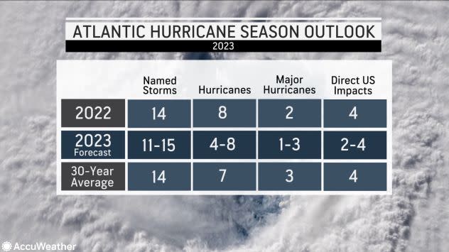
AccuWeather is predicting a hurricane season close to the 30-year historical average with 11-15 named storms, four to eight hurricanes, one to three major hurricanes and two to four systems that will directly impact the U.S.
 |
Outside of the tropical threat, the warm weather in the Gulf and Atlantic will "increase humidity levels and increase the chances of more showers and thunderstorms, especially if we see the pattern in June and July," Pastelok said.
Areas of drought developed over Florida and along small sections of the Gulf Coast during the first part of 2023, but a wet end to spring followed by the summertime storms and possible tropical impacts should wash away most of the drought concerns.
Similar to the Northeast and Midwest, Pastelok noted that areas of the Southeast could have some drier weather arrive after the calendar flips to August, but the month will still bring some rain, especially if a tropical system tracks near the region.
Severe thunderstorm activity was rampant throughout much of the United States during the start of the year, producing a record number of tornadoes through the first three months of 2023. While severe weather was not as prevalent in April and May, AccuWeather meteorologists expect more severe weather outbreaks during the summer months.
"Severe weather can be quite active across the north-central Plains, Midwest, Ohio Valley, Great Lakes and into the Northeast, especially in June and July," Pastelok explained. He added that Kansas City, St. Louis and Chicago may have more severe thunderstorms this summer, especially during the first half of the season, compared to the historical average.
There is also a moderate risk of severe weather in the mid-Atlantic this summer, including in New York City, Washington, D.C., and Pittsburgh. The risk will be slightly lower in New England, but storms can occasionally rumble over the region.
 |
Damaging winds, hail and isolated tornadoes will be possible with the most vigorous storms, but any thunderstorm can spark lightning.
Lightning kills about 20 people in the U.S. every year, and between 2006 and 2019, more than 70% of lightning-related deaths occurred in June, July or August. Anyone who is outdoors and hears thunder should seek shelter and remain indoors until the storm has passed, forecasters say.
 |
Lightning illuminates storm clouds over the Philadelphia skyline, Tuesday, Aug. 16, 2016, seen from across the Delaware River in Camden, N.J. (AP Photo/ Joseph Kaczmarek) |
The ongoing drought will limit the frequency of severe weather in portions of the central and southern Plains, including the area commonly known as Tornado Alley, similar to what unfolded last year.
In 2022, extreme drought from Texas to Nebraska hindered thunderstorm development. With the drought still prevalent and even more widespread in Nebraska, Kansas and Oklahoma compared to last year, summer storms will be limited again in the central Plains.
Pastelok said the region could have a small uptick in thunderstorm activity this summer compared to the 2022 summer, but the rain will only put a small temporary dent in the drought rather than quenching the parched region's thirst.
Sustained hot spells may slowly take hold over the western U.S. this year following a winter with historic snowfall and excessive rainfall. The lingering moisture in the ground, paired with the cool water off the immediate coast, will lead to a delayed start to summery weather in some of the region's biggest cities, such as Los Angeles, San Francisco and San Diego.
Low clouds and fog will be more frequent along the coast of California during the early part of the summer, limiting how high temperatures will rise. However, this will only delay the inevitable. "You're still gonna have your dry spots in California and parts of Nevada and Arizona that are going to heat up at times," Pastelok added. "No doubt about that."
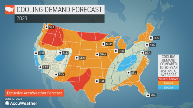
The interior Northwest and northern Rockies will have brief warmups early in the summer, but the heat will really turn up during the second half of July. As a result, the cooling demand is predicted to be much higher across the Northwest than in California, southern Nevada, Utah and Arizona, compared to historical averages.
 |
Not only will the arrival of long stretches of summer weather be delayed across the West, but so will the arrival of the annual monsoon season. While many may believe a monsoon is a heavy downpour, a monsoon is actually a large-scale change in the wind that can promote rain and thunderstorms over a region of the world spanning weeks or months.
In 2021 and 2022, the North American monsoon began around mid-June, but this year, AccuWeather meteorologists say that it may not kick into gear until July.
The monsoon will deliver some rain to the interior West, but the more significant concern will be the lightning associated with the storms. Lightning strikes can ignite wildfires that could burn for months. Storms may also disrupt outdoor plans and create flash flooding in and around some popular national parks across the western U.S.
 |
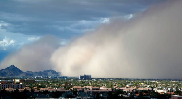
A large dust storm, or haboob, sweeps across downtown Phoenix Saturday afternoon, July 21, 2012. Dust storms are common across Arizona during the summer, and walls of dust more than a mile high can blanket an area in a matter of seconds, sometimes reducing visibility to zero. (AP Photo/Ross D. Franklin) |
Lightning from thunderstorms associated with the monsoon can spark fires across the West, serving as a natural ignition source for blazes during the upcoming wildfire season.
After three years when La Niña had a heavy hand in the storm track across North America, its reign has finally come to an end and has been swiftly replaced by its counterpart: El Niño. AccuWeather meteorologists say there are still some uncertainties surrounding El Niño and how it will influence the United States.
"How strong is it going to become? Is it rapidly going to intensify [during] the summer? The stronger the El Niño, the higher influence it will have," Pastelok explained.
El Niño is a regular climate pattern that occurs when the water near the equator of the eastern Pacific Ocean is warmer than historical averages. The warmer water can alter the jet stream in the Northern Hemisphere and the overall weather patterns thousands of miles away from the Pacific Ocean.
 |
Areas of yellow, orange and red near the equator in the Pacific Ocean and off the west coast of South America indicate where waters are warmer than historical average, indicative of a building El Nino. (NASA Worldview) |
How strong El Niño becomes will determine how exactly it will affect the weather in the U.S. this summer. Regardless of its strength, Pastelok said it would have more of an impact on the tropics than anywhere else. This is one reason why AccuWeather is not forecasting an above-normal Atlantic hurricane season.
El Niño will continue to reshape the weather patterns over North America through the remainder of 2023 and into the start of 2024.
Want next-level safety, ad-free? Unlock advanced, hyperlocal severe weather alerts when you subscribe to Premium+ on the AccuWeather app. AccuWeather Alerts™ are prompted by our expert meteorologists who monitor and analyze dangerous weather risks 24/7 to keep you and your family safer.
