UK weather: Thunderstorm and strong wind warnings as half month of rain to fall today
More than half a month’s rain could fall across the south of England on Friday as the weather takes a turn to unsettled conditions once again after last few days of sunshine.
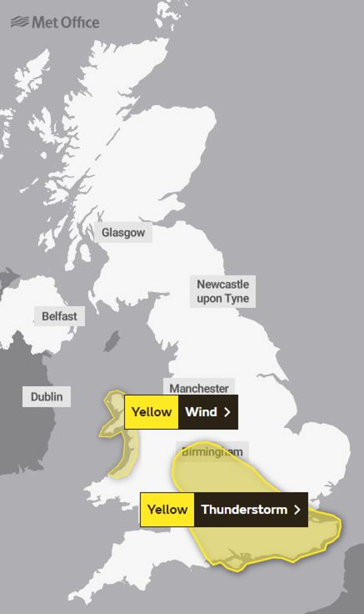
The Met Office has issued a weather warning for the south of England which could see 30mm to 40mm of rain in some spots in just six hours, much higher than the usual 63mm of rain that falls across the south-east of England over the entire month of August.
The warning covers large parts of the South and the West Midlands, including London as well as the whole of the South East and the Solent area, stretching to Birmingham at its northernmost edge, between 6am and midday on Friday.

Buildings and structures could be damaged by flooding and lightning strikes while homes could also lose power “for a short time”, the forecaster said.
There is also “a good chance” drivers in affected areas could be delayed by spray and standing water, and rail passengers could face longer journeys.
A heat health alert was issued earlier for large parts of the UK as the Met Office predicted the mercury to peak around 28C on Friday before unsettled weather returned.
The UK Health Security Agency issued a Yellow Heat Health Alert, which is specifically aimed at the health and social care sector in England.
This change in weather is due to a low-pressure system exerting its influence and bringing wind and rain for many over the weekend, the Met Office said.
After the heat, some heavy and at times thundery rain is also expected for many, as active weather fronts move from the southwest to the northeast, clearing northern Scotland on Saturday afternoon.
A yellow warning is also in place on Friday for winds in northern and western coastal areas of Wales, where wind gusts could very locally be in excess of 60mph, and more widely around 40-50mph.
“There’s an area of low-pressure to the west. This will orientate with the high pressure and will waft in some warmer air from the south in the next few days,” Met Office meteorologist Aidan McGivern said.
“Another area of low-pressure heads towards the UK at the start of Friday. The instability in the atmosphere will create a line of showers or even some thunderstorms and there could be some heavy downpours moving through central parts of the UK, though there is some uncertainty on the distribution.
“Where we do get some breaks in the cloud on Friday, it will still be a fairly warm day, though temperatures won’t be exceptional, and it will feel quite humid because of this southerly airflow.”
We've got some increasingly warm and humid nights to come over the next few days
By Friday night, many towns and cities won't see temperatures drop much below the mid to high-teens of Celsius 🌡️ pic.twitter.com/ofpGouemTO— Met Office (@metoffice) August 16, 2023
“The main event arrives during Friday evening, with the potential for intense thunderstorms to break out over parts of England, bringing a lot of rain in a short period of time, along with the risk of hail and frequent lightning.” Met Office deputy chief meteorologist Steven Keates added.
“At the same time heavy rain, initially arriving into the southwest, will fairly steadily move northeast, potentially bringing some substantial rainfall totals to parts of Northern Ireland and eastern Scotland in particular.”
Five day Met Office outlook
Friday:
Bands of heavy and thundery rain will push northeastwards throughout today. Dry, bright and feeling warm either side of this. Further heavy rain moving into the southwest later. Increasingly windy.
Friday night:
Remaining cloudy and rather windy tonight as outbreaks of heavy rain and thunderstorms push northeast. Turning drier from the southwest by dawn. Feeling very humid.
Saturday:
A rather cloudy and blustery start with outbreaks of heavy rain continuing northeastwards. Sunshine and showers continuing in the northwest, becoming drier and brighter for many though. Feeling warm.
Outlook for Sunday to Tuesday:
Less humid on Sunday with scattered showers becoming increasingly isolated to the northwest by Monday. Perhaps cloudier on Tuesday, although remaining dry for most. Feeling warm, especially in the southeast.
