UK weather – latest: Lightning and thunderstorm warning as heatwave continues
The Met Office has warned that travel disruption and flooding are likely across parts of the UK on Monday as a rare amber weather alert is issued for thunderstorms.
Thunderstorms are expected to bring heavy rainfall, lightning, strong winds, and hail, according to the Met Office, which could cause power cuts and damage to buildings in affected areas.
The amber warning applies to parts of the east and west Midlands, and the east, southeast and southwest of England.
The warning will last until 7pm on Monday.
Forecasters said: “A cluster or line of very active thunderstorms is moving towards the northwest from Bedfordshire and Buckinghamshire towards the West Midlands.
“These will bring a period of exceptionally heavy rainfall with 30-40mm falling in around 30 minutes, perhaps around 60mm in an hour for some locations.”
It comes as a yellow weather warning was issued for large parts of England including London, Oxford, Nottingham, and Manchester, with further alerts for Scotland and Northern Ireland, as thunderstorms hit the UK.
The Environment Agency also issued 14 flood alerts across the Midlands.
Key Points
Met Office issues rare weather warning as thunderstorms continue
Forecasters warn of ‘very active thunderstorms’ and ‘exceptionally heavy rainfall’ as amber alert issued for parts of UK
Lightning and thunderstorm warning as heatwave continues
‘Very warm’ weather predicted to continue as thunderstorms hit UK, Met Office says
Which areas are affected by the amber weather warning?
ICYMI: Met Office on how long heatwave will last after hottest day of year
03:40 , Martha Mchardy
Very warm weather is set to continue across the majority of the UK this week after temperatures hit highs of 32C on Sunday, the hottest day of the year so far.
Temperatures went above 30C over the weekend in parts of the UK for the first time since August 2022, the Met Office said.
However, large parts of the UK face warnings for thunderstorms with lightning strikes and torrential downpours forecast on Monday.
Warm and muggy conditions are expected to continue into Tuesday for most, according to the Met Office. However, showers and thunderstorms are expected in western Scotland and Northern Ireland.
However, Tuesday will be “a warmer feeling day in southwest England and southwest Wales compared to today,” Deakin said.
“The outlook is for more clear skies and not as many heavy thundery showers,” he said.
Martha McHardy reports:

Met Office on how long heatwave will last after hottest day of year
Worst of thunderstorms ‘has now passed,’ says Met Office meteorologist
02:40 , Martha Mchardy
The worst of thunderstorms “has now passed,” a Met Office meteorologist has said.
The Met Office has confirmed more settled weather can be expected heading into the rest of the week after parts of the UK were hit by thunderstorms.
An amber thunderstorm warning was issued on Monday as parts of UK were hit with heavy rain and strong winds, while roads were flooded around the country.
But Met Office forecaster and meteorologist Simon Partridge said the worst of the thunderstorms has now passed and drier weather is expected going into the latter parts of the week.
Very warm weather is set to continue across the majority of the UK this week after temperatures hit highs of 32C on Sunday, the hottest day of the year so far.
Warm and muggy conditions are expected on Tuesday for most, according to the Met Office. However, showers and thunderstorms are expected in western Scotland and Northern Ireland.
However, Tuesday will be “a warmer feeling day in southwest England and southwest Wales compared to today,” Deakin said.
“The outlook is for more clear skies and not as many heavy thundery showers,” he said.
Looking to the rest of the week, sunshine is expected to continue, according to the Met Office forecast.
Deakin said: “We’re going to lose some of the humidity. Temperatures just dropping down a touch, but still likely to get into the mid to high twenties, and nights becoming a little more comfortable, but only a little bit.”
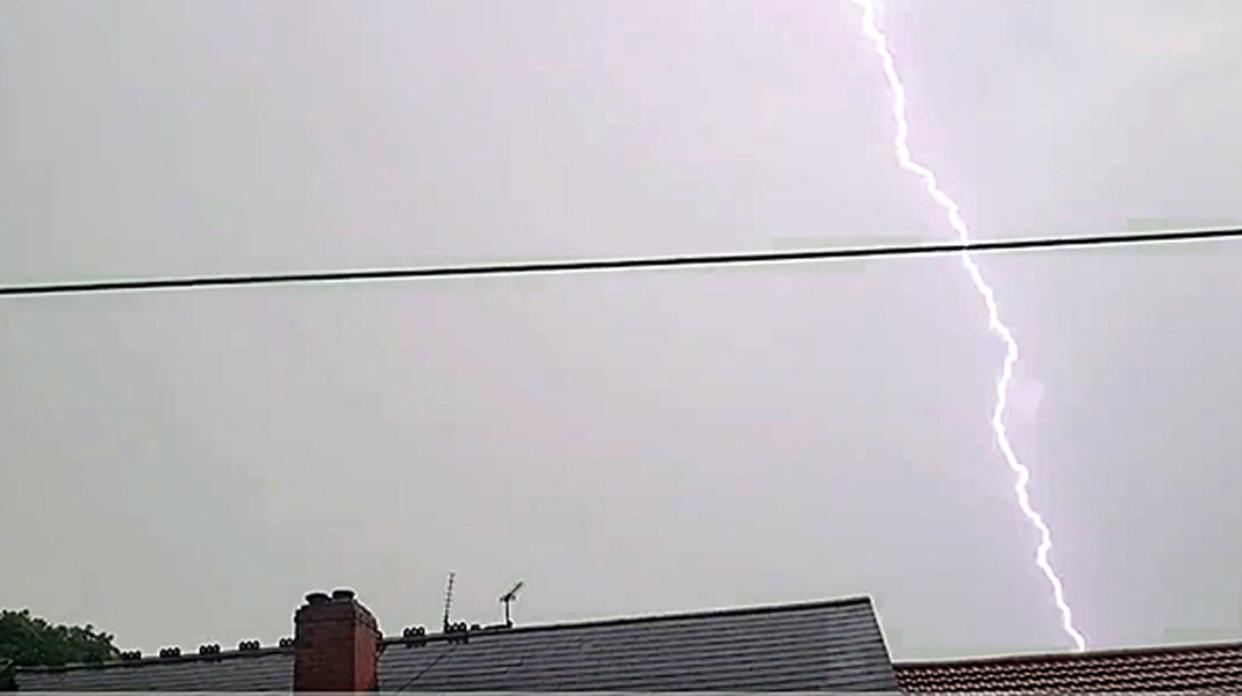
Watch: Dark thunderstorm over West Midlands captured in time-lapse footage
01:40 , Martha Mchardy
Woman trapped in car due to floods in Wales
Tuesday 13 June 2023 00:40 , Martha Mchardy
Bookshop owner Emma Corfield-Walters was briefly trapped in her car when a flash flood hit Crickhowell, Wales.
She told PA news agency: “The flooding was on the High Street in Crickhowell and happens every 2-3 years when we have a short heavy rain storm and the ground is hard and dry.
“The drains don’t cope and sadly the business at the bottom end of the High Street are flooded.
“As it’s an ongoing issue I’m at a loss to know why flood prevention measures haven’t been put in place or adapted.
“Water has entered The Britannia Pub and Grenfell and Sons which is a village store that sells everything. Both family run businesses.”
Sadiq Khan issues air pollution warning to London as heatwave continues
Monday 12 June 2023 23:40 , Martha Mchardy
The Mayor of London has also issued a high air pollution warning to those in the capital, the second of the year, caused by high temperatures and pollution being carried over from the continent.

Sadiq Khan has asked people to do their part to stop themselves contributing to the pollution levels, adding: “Pollution and heat can be a dangerous combination, which is why I’m urging Londoners to look after themselves and each other by choosing to walk, cycle or take public transport, avoid unnecessary car journeys, stop their engines idling and refrain from burning wood or garden waste, all of which contribute to high levels of pollution.
“This is particularly important in order to protect those who are most vulnerable and help us to build a safer and greener London for all.”
Yellow weather warnings issued for Tuesday
Monday 12 June 2023 22:40 , Martha Mchardy
The Met Office has issued yellow thunderstorm warnings for Tuesday to parts of western Scotland and Northern Ireland.
The warnings will be in place from 12pm to 9pm, with areas affected expected to see heavy rainfall, hail and thunderstorms.
However, Tuesday is expected to be another hot day across the UK as both London and Manchester are forecast to see highs of 28C during the day.
UK to return to dry, sunny weather after being hit by thunderstorms
Monday 12 June 2023 21:41 , Martha Mchardy
The UK saw rain, hail and thunderstorms batter regions on Monday, but the Met Office has confirmed more settled weather can be expected heading into the rest of the week.
An amber thunderstorm warning was issued on Monday as parts of UK were hit with heavy rain and strong winds, while roads were flooded around the country.
But Met Office forecaster and meteorologist Simon Partridge said the worst of the thunderstorms has now passed and drier weather is expected going into the latter parts of the week.
He said: “We’ve had some very heavy thunderstorms today. Quite widely we’ve seen around 15mm of rain fall within one hour but in one or two spots we did see close to 30mm of rain in an hour which has caused some localised flooding which was very short-lived.
“It also created some very tricky driving conditions for a spell too.
“The good news is the worst of it is now leaving, as we cool down through the evening it will give the thunderstorms less energy and it will be starting to clear into the Irish Sea.
“We do, already, have some thunderstorm warnings out for tomorrow. These are looking like they’re going to be down a notch or two compared to what we’ve seen today.
“We’ve got high pressure starting to rebuild over the course of the day and when you get high pressure that’s what gives us lots of dry, settled weather, like what we’ve had over the last couple of weeks.
“That’s becoming more established tomorrow and through the week so we will see a lot of the country tomorrow be dry with sunny spells.
“The thunderstorms have gradually been working their way westwards over the last couple of days because the area of the warmest and most humid air has drifted its way westwards, as a result, tomorrow we’re expecting to see thunderstorms across parts of western Scotland and Northern Ireland.
“A few heavy rain spells are possible and could see some heavy downpours so there is the potential to see 20mm-plus of rain over a couple of hours, so not as much as we’ve seen over the last couple of days but certainly enough that anyone travelling will have to be aware.”
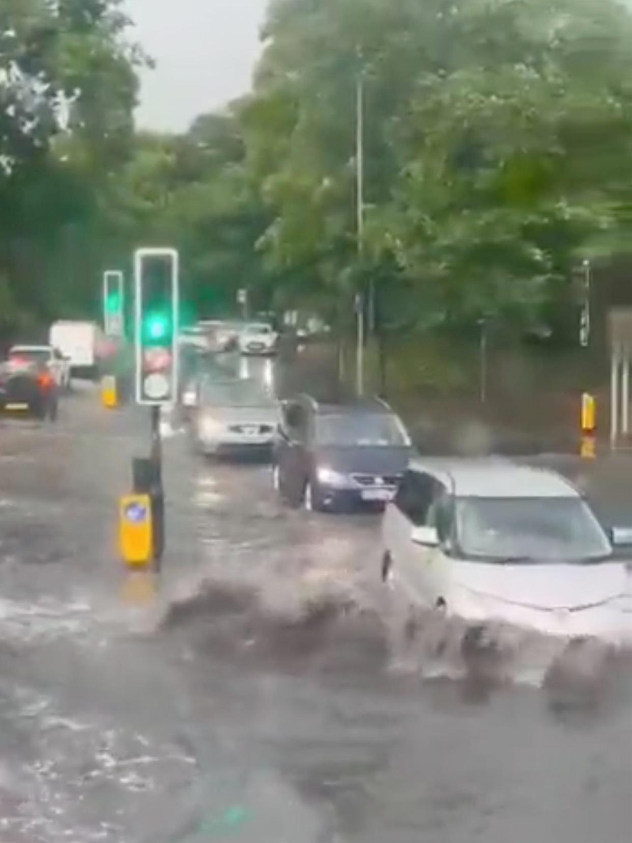
Watch: Maidenhead streets flooded as thunderstorms hit England
Monday 12 June 2023 20:40 , Martha Mchardy
ICYMI: Which areas are affected by the amber weather warning?
Monday 12 June 2023 20:20 , Martha Mchardy
The Met Office issued an amber weather warning for parts of the east and west Midlands, and the east, southeast and southwest of England, amid warnings of flooding.
Which areas are affected?
East Midlands
Derby
Derbyshire
Leicester
Leicestershire
Northamptonshire
Nottingham
Nottinghamshire
Rutland
South East England
Buckinghamshire
Oxfordshire
South West England
Gloucestershire
West Midlands
Herefordshire
Shropshire
Staffordshire
Stoke-on-Trent
Telford and Wrekin
Warwickshire
West Midlands Conurbation
Worcestershire
Watch: Dark thunderstorm over West Midlands captured in time-lapse footage
Monday 12 June 2023 20:00 , Martha Mchardy
Thunderstorm warning today as Britons face lightning strikes and torrential downpours
Monday 12 June 2023 19:30 , Martha Mchardy
Large parts of the UK face warnings for thunderstorms with lightning strikes and torrential downpours forecast on Monday.
The Met Office alerts come after scorching temperatures hit highs of 32C on Sunday, the hottest day of the year so far.
The yellow warnings cover large parts of England including London, Oxford, Nottingham, and Manchester, with further alerts for Scotland and Northern Ireland.
The warnings are in place from midday until 9pm on Monday and temperatures are again expected to be close to 30C.
“We’re expecting a fine and hot start, temperatures rising fairly quickly during the course of the morning under strong early summer sunshine and that’s likely to spark a few thundery showers,” Met Office meteorologist Dan Stroud said.
Stuti Mishra reports:

Thunderstorm warning today as Britons face lightning strikes and torrential downpours
Man City treble parade delayed due to ‘adverse weather'
Monday 12 June 2023 19:12 , Martha Mchardy
The Manchester City treble parade has been delayed amid “adverse weather” conditions in the city.
Fans of the football club have lined the streets of Manchester this evening to celebrate their Champions League win in Istanbul in this weekend.
A bus parade is scheduled to take place through Manchester city centre this evening, with players expected to arrive on stage before the event finishes.


However, fans have been warned that access to the stage has been limited due to “adverse weather conditions” this evening, as Manchester sees torrential downpours and lightning storms, the club said.
According to the Manchester City website, gates for the show stage will no longer open at 5pm with access delayed until 7pm. The show had been due to start at 5.30pm.
In a statement, they said: “Trophy Parade update: Access to stage show site delayed due to reports of adverse weather conditions and lightning storms.
“This decision has been taken in the interests of safety by Manchester City Council in conjunction with the Club and other local stakeholders, who have consulted with meteorologists and the Met Office.”
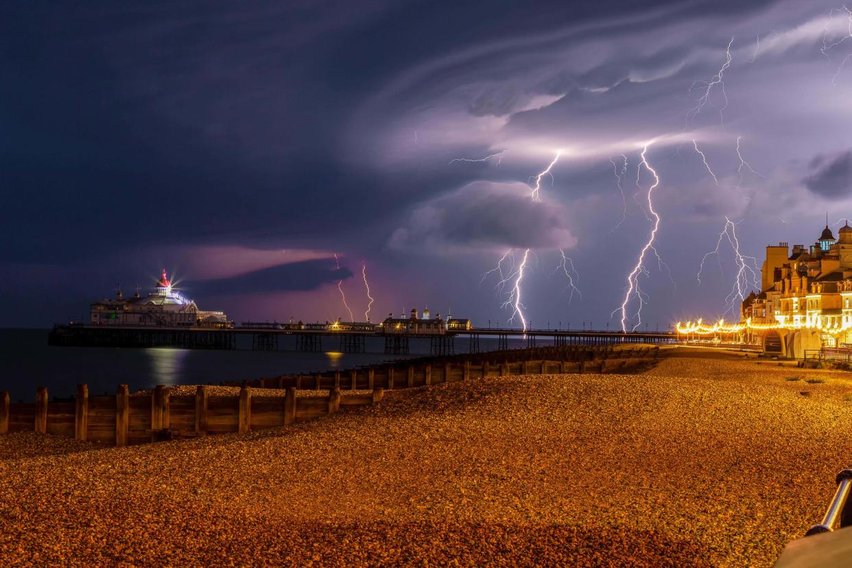
In pictures: Thunderstorms and fog hit UK as heatwave continues
Monday 12 June 2023 19:10 , Martha Mchardy

Pictures show cars driving through floods in Maidenhead
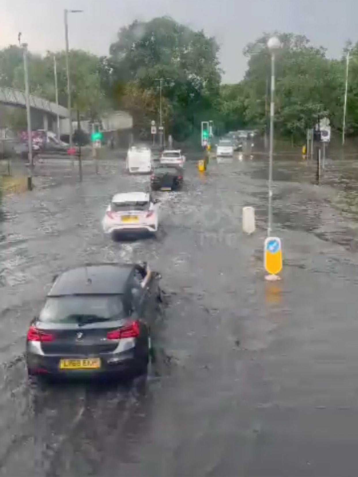
Monday 12 June 2023 19:02 , Martha Mchardy
Roads in Maidenhead, Berkshire are flooded after thunderstorms hit parts of the UK.
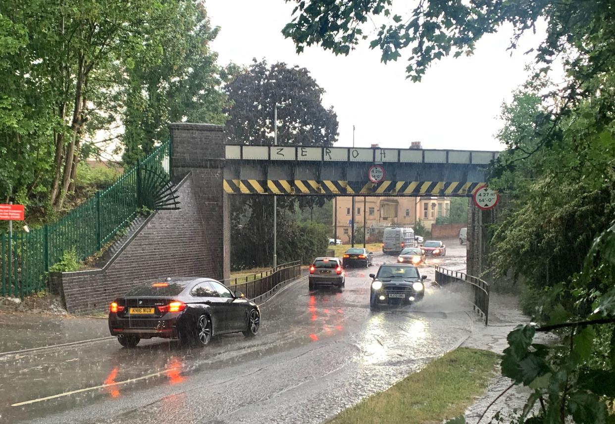
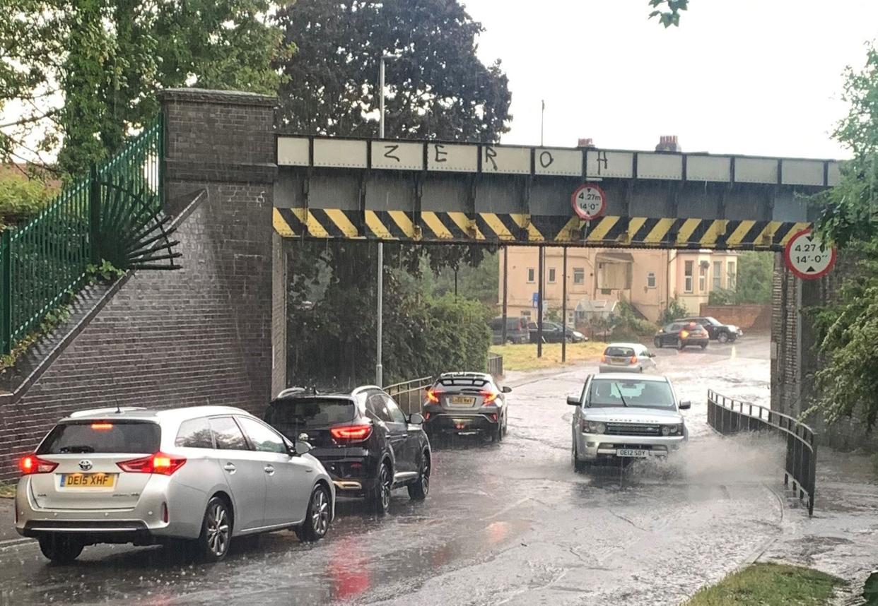
The Met Office has issued an amber weather warning as thunderstorms are expected to bring heavy rainfall, lightning, strong winds, and hail to large parts of England
Travel disruption and flooding are likely to be caused by thunderstorms in the east and west Midlands, and the east, southeast and southwest of England, the Met Office said.
UK weather forecast this week
Monday 12 June 2023 18:45 , Martha Mchardy
Higher temperatures are concentrated in the North, with Manchester, Leeds, and Keswick, Cumbria, between 30C and 31C, while south-central England remains in the high 20s, with London and Cambridge both reaching between 27C and 28C.
Further thunderstorms may be possible in the first half of the week, with fresher conditions and temperatures slightly decreasing towards Thursday and Friday.
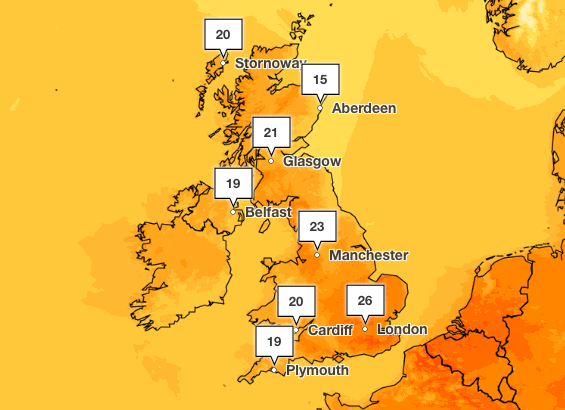
However, the sunny weather is staying with most parts of the country and forecast to remain above 24C and 25C throughout the week, and potentially reaching 29C in Bristol and Birmingham over Wednesday and Thursday.
Cooler air from the North Sea will reach parts of the UK on Thursday and Friday, particularly areas along the North Sea coast and the East of England.
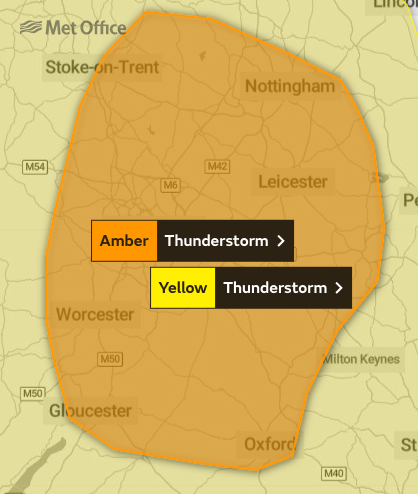
Mapped: Which areas are affected by the amber weather warning?
Monday 12 June 2023 18:25 , Martha Mchardy
The Met Office issued an amber weather warning for parts of the east and west Midlands, and the east, southeast and southwest of England, amid warnings of flooding.
A yellow weather warning was also issued for large parts of England including London, Oxford, Nottingham, and Manchester, with further alerts for Scotland and Northern Ireland, as thunderstorms hit the UK.
What is an amber weather warning?
Monday 12 June 2023 18:00 , Martha Mchardy
The Met Office has issued an amber thunderstorm warning as parts of the UK are set to be battered by heavy rain, lightning, hail and strong winds.
The warning came into force on Monday as the forecaster said power cuts and flooding of homes, businesses and roads, as well as delays and cancellations to train and bus services, are “likely”.
Driving conditions could also become difficult and some communities could be temporarily cut off if roads flood, the Met Office added.
The warning, which covers parts of Leicester, Birmingham, Worcester, Gloucester and Oxford, will be in place until 7pm on Monday.
According to the Met Office website, an amber weather warning is issued when “there is an increased likelihood of impacts from severe weather, which could potentially disrupt your plans.
“This means there is the possibility of travel delays, road and rail closures, power cuts and the potential risk to life and property,” the Met Office said.
How to track lightning in your area as thunderstorm warning issued
Monday 12 June 2023 17:40 , Martha Mchardy
Confused Brits currently sunbathing in the balmy temperatures or at the beach can now track where a thunderstorm is likely to hit and find themselves cover from the sudden weather change.
Radar Live has a thunderstorm tracker and lightning map which allows you to track storms as they move across the UK and rest of the world.
As the map below shows, areas of the country covered in colourful blobs are suffering from adverse weather such as heavy rainfall and storms.
If you click on a specific area on the map, such as London, it will give you information about the current weather and expected future forecasts and temperatures.
Joe Middleton reports:

How to track lightning in your area as thunderstorm warning issued
London Fire Brigade called to several reports of flooding across London
Monday 12 June 2023 17:16 , Martha Mchardy
The London Fire Brigade (LFB) was called to several reports of flooding across London on Monday afternoon.
It comes as the Met Office issued an amber weather warning for parts of the east and west Midlands, and the east, southeast and southwest of England, amid warnings of flooding.
The Met Office also warned flooding could cause power cuts in affected areas and warned some communities in the Midlands are likely to become temporarily cut off if roads flood.
In a message posted on Twitter, the LFB said: “Never drive through floodwater - a foot of moving water at just 6mph is enough to float a car. Always try and find an alternative route.”
We have been called to several reports of flooding across London this afternoon following thunderstorms, affecting roads and properties ⛈️
Never drive through floodwater - a foot of moving water at just 6mph is enough to float a car. Always try and find an alternative route. https://t.co/j66TZFSB8w— London Fire Brigade (@LondonFire) June 12, 2023
Pictures show flooding on road in London as UK hit by thunderstorms
Monday 12 June 2023 17:11 , Martha Mchardy
Which areas are affected by the amber weather warning?
Monday 12 June 2023 16:55 , Martha Mchardy
The Met Office issued an amber weather warning for parts of the east and west Midlands, and the east, southeast and southwest of England, amid warnings of flooding.
Which areas are affected?
East Midlands
Derby
Derbyshire
Leicester
Leicestershire
Northamptonshire
Nottingham
Nottinghamshire
Rutland
South East England
Buckinghamshire
Oxfordshire
South West England
Gloucestershire
West Midlands
Herefordshire
Shropshire
Staffordshire
Stoke-on-Trent
Telford and Wrekin
Warwickshire
West Midlands Conurbation
Worcestershire
Meteorologist urges people to ‘prepare themselves’ amid amber weather warning for thunderstorms
Monday 12 June 2023 16:51 , Martha Mchardy
Meteorologist Grahame Madge has urged people in warning areas to prepare themselves after a rare amber weather warning for thunderstorms was issued by the Met Office.
He said: “Within the area we are advising that people might want to think about how suddenly they can be subjected to flash flooding or a power cut. Are people prepared? Make sure mobile phones are charged and that sort of thing.
“Because when you get these storms they can change your circumstances quite dramatically within almost a matter of minutes.”
Mr Madge said that heat rising from freshly ploughed fields or over a city area could trigger thunderstorms even when nearby areas remain dry.
Flash flooding can occur in a few minutes.
Urban areas can be vulnerable to flash flooding as the rain hits surfaces such as pavements which cannot absorb heavy downpours, leaving it to flow into drains or roads.
Underpasses can also fill quickly and drivers could face flood water on roads.
‘Very warm’ weather predicted to continue as thunderstorms hit UK, Met Office says
Monday 12 June 2023 16:47 , Martha Mchardy
Very warm weather is set to continue across the majority of the UK this week as thunderstorms hit the UK.
It comes as temperatures went above 30C over the weekend in parts of the UK for the first time since August 2022, the Met Office said.
However, large parts of the UK face warnings for thunderstorms with lightning strikes and torrential downpours forecast on Monday.
A yellow weather warning is in place until 9pm on Monday for large parts of England including London, Oxford, Nottingham, and Manchester, with further alerts for Scotland and Northern Ireland.
Meanwhile, the Met Office issued an amber weather warning for parts of the east and west Midlands, and the east, southeast and southwest of England, amid warnings of flooding.
Met Office Meteorologist Alex Deakin said while conditions are likely to be “dry and very warm and humid for the majority,” the heat and humidity are “likely to spark some big thunderstorms” across Wales, northern England, Northern Ireland and Scotland on Monday evening.
Martha McHardy reports:
Met Office on how long heatwave will last after hottest day of year
Met Office issues rare weather warning as thunderstorms continue
Monday 12 June 2023 16:39 , Martha Mchardy
The Met Office has issued a rare amber weather warning as thunderstorms continue across parts of England.
Thunderstorms are expected to bring heavy rainfall, lightning, strong winds, and hail, according to the Met Office, with travel disruption and flooding likely.
The Met Office also warned flooding could cause power cuts in affected areas and warned some communities in the Midlands are likely to become temporarily cut off if roads flood.
Martha McHardy reports:

Met Office issues rare weather warning as thunderstorms continue
Forecasters warn of ‘very active thunderstorms’ and ‘exceptionally heavy rainfall’ as amber alert issued for parts of UK
Monday 12 June 2023 16:37 , Martha Mchardy
An amber weather warning for thunderstorms has been issued for parts of the east and west Midlands, and the east, southeast and southwest of England.
Forecasters said: “A cluster or line of very active thunderstorms is moving towards the northwest from Bedfordshire and Buckinghamshire towards the West Midlands.
“These will bring a period of exceptionally heavy rainfall with 30-40mm falling in around 30 minutes, perhaps around 60mm in an hour for some locations.
“Frequent lightning strikes, winds that may gust to 45 mph, and some large hail stones perhaps up to 4cm in diameter will also accompany the storms.
“Surface water flooding may happen very quickly, likely disrupting travel and flooding some properties (especially in urban areas).
“Lightning, strong winds and hail will all pose a significant danger to those outdoors. The ultimate northwestern extent of this area remains somewhat uncertain.”
EasyJet cancels over 100 Gatwick flights, stranding at least 15,000 passengers
Monday 12 June 2023 16:34 , Martha Mchardy
At least 15,000 passengers have had their journey plans wrecked after easyJet cancelled more than 100 flights in 24 hours to and from its main base, London Gatwick.
Britain’s biggest budget airline is blaming thunderstorms on Sunday at the Sussex airport for the cancellations.
But other carriers at Gatwick have grounded far fewer flights.
Gatwick is the busiest single-runway airport in the world, and therefore especially susceptible to weather-related disruption.
Simon Calder reports:

EasyJet cancels over 100 Gatwick flights, stranding at least 15,000 passengers
Lightning and thunderstorm warning as heatwave continues
Monday 12 June 2023 16:33 , Martha Mchardy
The Met Office has warned that travel disruption and flooding are likely across parts of the UK on Monday as a rare amber weather alert is issued for thunderstorms.
Thunderstorms are expected to bring heavy rainfall, lightning, strong winds, and hail, according to the Met Office, which could cause power cuts and damage to buildings in affected areas.
The amber warning applies to parts of the east and west Midlands, and the east, southeast and southwest of England.
The warning will last until 7pm on Monday.
Forecasters said: “A cluster or line of very active thunderstorms is moving towards the northwest from Bedfordshire and Buckinghamshire towards the West Midlands.
“These will bring a period of exceptionally heavy rainfall with 30-40mm falling in around 30 minutes, perhaps around 60mm in an hour for some locations.”
It comes as a yellow weather warning was issued for large parts of England including London, Oxford, Nottingham, and Manchester, with further alerts for Scotland and Northern Ireland, as thunderstorms hit the UK.
The Environment Agency also issued 14 flood alerts across the Midlands.
Temperatures hit highs of 32C on Sunday, the hottest day of the year so far.
Very warm weather is set to continue across the majority of the UK this week, the Met Office has predicted.
