Typhoon Mawar – latest: Updates as Philippines braces for 175mph category 5 super cyclone
Typhoon Mawar, locally known as Betty, was moving westwards across the Pacific Ocean in the direction of the Philippines on Sunday after it wreaked havoc on the US territory of Guam with harsh winds and rain.
On Sunday night, the centre of Mawar was about 360 miles from the largest and most populous island of the Philippines – Luzon – according to the Philippine meteorological agency.
The storm was moving west at 8 mph with winds reaching 120 mph, the Joint Typhoon Warning Center said. The agency is run by the US Navy.
In the US, the wind speed is comparable to that of a Category 3 hurricane.
Forecasters have said that the storm is likely to remain north of the Philippines and weaken from the beginning of next week, according to The New York Times.
But the Philippine weather agency said that northern Luzon was expected to be struck by rains, flooding, landslides, and strong winds.
Some parts of the island nation were also expected to be hit by almost four inches of rain on Tuesday morning.
Key points
The identical twin weathermen protecting an island from a deadly 140mph typhoon
Mawar to ‘remain stagnant’ east of Taiwan for ‘days'
PHOTOS: Police in Philippines help residents reinforce homes ahead of typhoon arrival
Guam: Footage Of Violent Winds Lashing Resort Area During Typhoon Mawar Onslaught
From Odette to Mawar: The most powerful typhoons to hit the Philippines
Typhoon Mawar now moving at 10kmh, PAGASA says in latest advisory
11:30 , Stuti Mishra
Typhoon Mawar, known in the Philippines as storm Betty, was last pinpointed 445km east of Calayan island at the northern part of the archipelago, the Philippine Atmospheric, Geophysical and Astronomical Services Administration (PAGASA) said in its 5pm local time update today.
The typhoon is now moving at a reduced speed of 10kmh toward northwest, with its projected path showing the cyclone will pass through the country but not make direct landfall.
It is expected that the typhoon will begin moving away from the Philippines, towards Taiwan and Southern China, in the next two days after inching closer. It is expected to stagnate in the region for a while and continue to lose its intensity by the end of the week.
Why does the Philippines change names of cyclones?
10:45 , Stuti Mishra
Typhoon Mawar, which wreaked havoc in Guam last week, is now being called "Betty" since it moved into the oceanic area monitored by the Philippines.
While the name change can be confusing for a lot of people, Mawar isn't the only cyclone to be renamed and known locally with a different name in the Philippines.
The Philippines, in fact, changes the names of all its typhoons once they enter the so-called Philippines Area of Responsibility (PAR), a large area of the Western North Pacific which includes most of the country's land territory, the main island of Palau, most of Taiwan, as well as parts of Malaysia and the Japanese prefecture of Okinawa.
From typhoon Odette, which was previously named typhoon Rai, to the Philippines' deadliest typhoon in modern history, typhoon Yolanda, which was previously called typhoon Haiyan, all these storms went through a change of name after crossing the line in the ocean.
Agencies such as the World Meteorological Organisation (WMO) name cyclones that occur in the Pacific to help in the quick identification of storms in warning messages.
However, since the PAR region is monitored by the Philippine Atmospheric, Geophysical and Astronomical Services Administration (PAGASA), it independently operates its own naming scheme for tropical cyclones that occur within the territory.

The state weather bureau assigns each Philippine typhoon name alphabetically to determine the number of typhoons that enter PAR every year. The Philippines is one of the most exposed countries in the world to tropical cyclones.
PAGASA also maintains a back-up list if all 25 names are used in a year.
Some of these names are also local Filipino names that help with quick recall of the storms that enter its monitored area.
FEMA provides update on Guam recovery efforts
10:00 , Gustaf Kilander
#Mawar Update: Our teams are on the ground assessing damages in all affected areas. We're moving pallets of food & water from our Guam distribution center to supplement territorial supplies at points of distribution & shelters housing survivors.
More: https://t.co/WJlwForIID pic.twitter.com/cHsQ8K8dAU— FEMA (@fema) May 28, 2023
In Photos: Coastal regions evacuated and aid arrives as Philippines prepares for extreme weather
09:15 , Stuti Mishra


Preemptive evacuation underway in Philippines
08:30 , Stuti Mishra
Over a hundred people have been evacuated from the coastal areas of the Philippines as typhoon Mawar raises alerts for heavy rains and gusts of winds.
The authorities in the northern Cagayan Valley yesterday moved 38 families, or 113 individuals away as a pre-emptive evacuation, reported Rappler.
It comes as the state weather agency issued alerts for landslides, heavy rains and destructive winds for the next few days sparked by typhoon Mawar.
The identical twin weathermen protecting an island from a deadly 140mph typhoon
08:00 , Audrey McAvoy
As Typhoon Mawar aimed its fury at Guam, residents facing terrifying winds and crashing waves from the strongest typhoon to hit the US Pacific territory in decades had identical twin meteorologists to keep them informed — and to provide the outside world with a glimpse of the chaos unfolding on the remote island.
The National Weather Service‘s Guam office employs Landon Aydlett as its warning coordination meteorologist. His brother Brandon Aydlett is the science and operations officer.
Together, the 41-year-olds tag-teamed Facebook Live broadcasts watched by thousands as Typhoon Mawar approached with maximum sustained winds of 140 mph (225 kph), wreaking havoc as residents lost power, internet and water service.
Their colorful descriptions of the Category 4 storm painted a picture as they both took turns describing trees snapped like toothpicks, thrashing winds, nearly 2 feet (0.6 meters) of torrential rain and “whiteout conditions” outside the office where they holed up with other colleagues for nearly 48 hours.
Read more:

The identical twin weathermen protecting an island from a 140mph typhoon
New satellite image shows Typhoon Mawar close to Philippines
07:30 , Stuti Mishra
A satellite image released by Nasa shows the typhoon inching close to the Philippines as the country braces for heavy rains and winds.
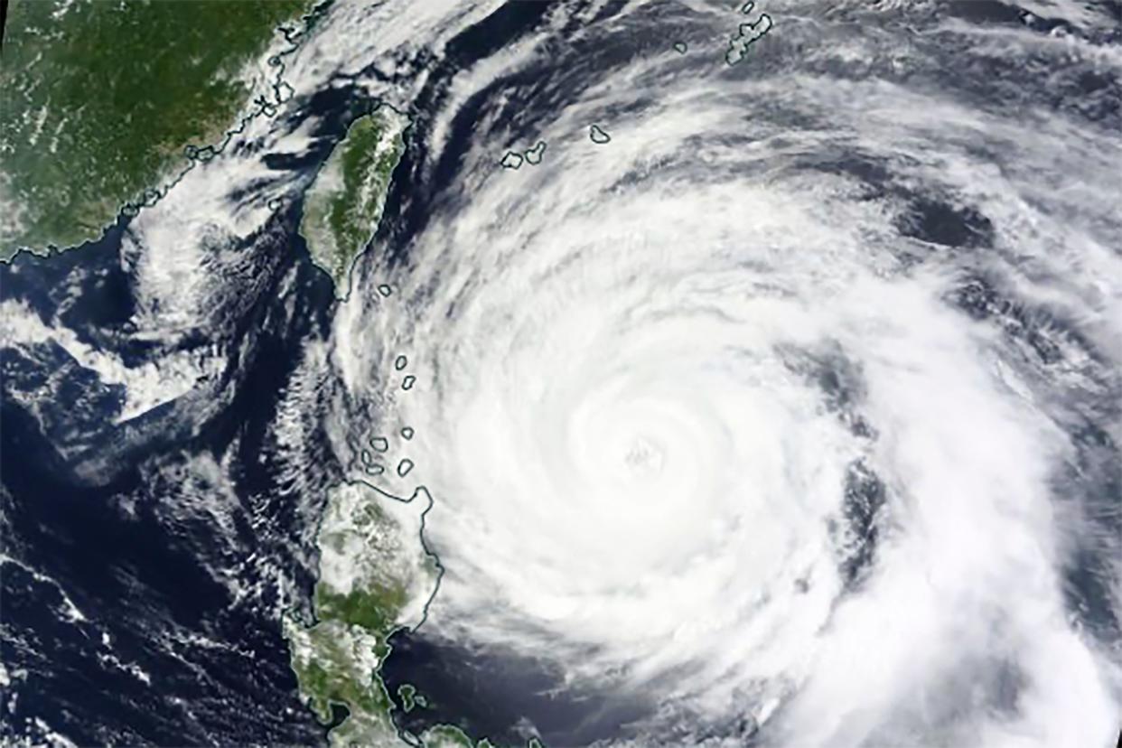
The cyclone is expected to come closer to the southeastern country in the next two days in its westward journey. After that, it is expected to more towards the north away from the Philippines and towards Taiwan and Japan
Luzon expected to be struck by rains, flooding, landslides, and strong winds
07:00 , Stuti Mishra
Typhoon Mawar, locally known as Betty, was moving northwest in the direction of the Philippines and Taiwan this morning after it wreaked havoc on the US territory of Guam last week with harsh winds and rain.
On Monday morning, typhoon Mawar was 470km east of the largest and most populous island of the Philippines – Luzon - prompting alerts for heavy rains and wind and some evacuations.
The Philippine weather agency said that northern Luzon was expected to be struck by rains, flooding, landslides, and strong winds.
Some parts of the island nation were also expected to be hit by almost four inches of rain today or tomorrow morning.
“Under these conditions, flooding and rain-induced landslides are likely,” the Philippine Atmospheric, Geophysical and Astronomical Services Administration (PAGASA) said in its 11am local time update today.
The cyclone currently has maximum sustained winds of 155 kmh near the centre and gusts of up to 190 kmh, considerably down from its intensity last week.
Mawar is set to move north and subsequently northeast, with the effects in Taiwan, China, and South Korea likely to be reduced to some heavy rainfall.

Mawar to 'steadily weaken' over next five days
06:25 , Stuti Mishra
Typhoon Mawar, now known as Betty locally, is forecast to "steadily weaken over the next five days", according to the latest update from Philippine Atmospheric, Geophysical and Astronomical Services Administration (PAGASA) today.
The storm, which maintained its intensity as a "super typhoon" for over 60 hours last week leaving scientists calling it a "beast", has now gradually started to weaken as it inches close to the Philippines.
A super typhoon is equivalent to a category 5 hurricane, while the current speed of the cyclone puts it in category 4.
The weather agency expects the cyclone to go further down in intensity as it encounters cooler waters northwards towards the sea of Japan.
TROPICAL CYCLONE BULLETIN NO. 10
Typhoon #BettyPH (MAWAR)
Issued at 11:00 AM, 29 May 2023
Valid for broadcast until the next bulletin at 5:00 PM today.
TYPHOON #BettyPH SLIGHTLY DECELERATES WHILE MOVING NORTHWESTWARD OVER THE WATERS EAST OF CAGAYAN.https://t.co/iqWDkvVJK6 pic.twitter.com/A6tW9TDS0j— PAGASA-DOST (@dost_pagasa) May 29, 2023
Betty may be downgraded into a severe tropical storm late on Thursday or early Friday and into a tropical storm by the end of the week, the agency says.
Typhoon Ompong (Mangkhut) 2018
06:00 , Stuti Mishra
Super typhoon Mangkhut caused extensive damages in Guam, the Philippines, and South China in September 2018.
It was also the strongest typhoon to affect Hong Kong since Ellen in 1983.
With highest winds of 285kmh, the typhoon made landfall in northern Cagayan valley, leaving a trail of destruction in its wake.
The torrential rainfall triggered landslides and destroyed buildings. Almost all buildings in Tuguegarao, Cagayan‘s provincial capital experienced some sort of damage due to the typhoon.
The storm caused a total of $3.77bn (£3.05bn) in damage across multiple nations, along with at least 134 fatalities reported: 127 in the Philippines, six in mainland China, and one in Taiwan.
Typhoon Glenda (Rammasun) 2014
05:00 , Stuti Mishra
The typhoon left 225 people dead and unleashed destructive impacts across the Philippines, South China, and Vietnam in July 2014.
It reached the Philippines after passing directly over Guam with a wind speed of 260kmh and a rainfall volume of 200mm.
This typhoon caused damage amounting to over $771m (£625m). It also left almost 90 per cent of Manila residents without power for days.
Typhoon Pablo (Bopha) 2012
04:00 , Stuti Mishra
Another typhoon that caused heavy devastation in the Philippines region was the 2012’s Bopha, or locally named Pablo. It was considered the strongest tropical cyclone to ever hit Mindanao island.
Recording over 280kph of winds, the typhoon made landfall in three separate locations: Northern Mindanao, Central Visayas, and Palawan.
It affected over five million people and left at least 1,900 people dead.
The damages from the cyclone stood at $1.16m (£939m), the third costliest for the southeastern nation.
Typhoon Odette (Rai) 2021
03:00 , Stuti Mishra
Typhoon Rai, known in the Philippines as super typhoon Odette, was the second costliest typhoon in Philippine history behind Typhoon Yolanda.
It swept through 11 of the country’s 17 regions in December 2021, leaving behind a trail of flattened homes, damaged farms, and other food sources, severely affecting people’s lives and livelihoods.
It killed 410 people and cost about $1.02bn (£972m).
Typhoon Yolanda (Haiyan) 2013
02:00 , Stuti Mishra
The deadliest to strike the Philippines in recent years was typhoon Yolanda, which left over 6,300 people dead in November 2013.
With winds of 315kmh, it was also the world’s strongest tropical cyclone of 2013, and devastated the central part of the country, particularly Tacloban City.
The storm surge, reaching up to 25 feet in some areas, resulted in widespread destruction with many buildings destroyed. It cost damages of about $2.98bn (£2.41bn), the costliest in Philippines history.
From Odette to Mawar: The most powerful typhoons to hit the Philippines
01:00 , Stuti Mishra
As typhoon Mawar barrelled its way towards the Philippines as a “super typhoon”, the nation braced itself for a weekend of heavy rains and winds.
After rapidly intensifying to become the most powerful storm of 2023 after battering Guam, typhoon Mawar posed a significant threat with peak winds reaching 215kph and gusts nearing 265kph.
The Philippines is considered the most exposed country in the world to tropical storms as approximately 20 cyclones enter the Philippine Area of Responsibility (PAR), the area of the ocean the country monitors, yearly.
As the country once again prepares for the onslaught of this powerful cyclone, here are some of the strongest storms that have battered the country in recent times.
Read more:

From Odette to Mawar: The most powerful typhoons to hit the Philippines
‘We are one Guam. We are one Marianas. Stay sheltered and stay safe'
Monday 29 May 2023 00:00 , Audrey McAvoy
The weather service office issues forecasts for Guam as well as several islands to the north — Saipan, Tinian and Rota — that are part of the Commonwealth of the Northern Mariana Islands, another U.S. territory. The Guam office also forecasts weather for the nearby independent Pacific island nations of the Marshall Islands, Micronesia and Palau.
On Thursday, in their final live update as the storm began to subside, they kept passing the informational baton back and forth. It would be their last update from Guam, Landon Aydlett said, after nearly 48 hours together in the forecasting office.
“I don’t know what my house is looking like right now,” he said. “I’ll find out very soon, but we will ride it out together. We are one Guam. We are one Marianas. Stay sheltered and stay safe.”
From North Carolina to Guam
Sunday 28 May 2023 23:00 , Audrey McAvoy
The brothers are from Elizabeth City, North Carolina, a small farming town in the Outer Banks about an hour south of Norfolk, Virginia. Brandon Aydlett came to Guam first, more than 13 years ago, and his brother arrived a half-year later.
The brothers like to go hiking and paddleboarding. Brandon Aydlett enjoys running. Landon Aydlett — who at Thursday’s final briefing sported a necklace of small white shells gifted to him after a 2018 typhoon — prefers to lift weights. Last year they broke two Guinness world records by building the world’s largest and tallest toy timber tower as part of a Habitat for Humanity fundraiser. The “Tower for Humanity” raised $20,000 for the Guam chapter of the charity.
Landon Aydlett said he’s heard about spouses working together in National Weather Service offices, but never about other twins.
Guam is an island of about 150,000 people about 3,900 miles (6,275 kilometers) west of Hawaii and 1,600 miles (2,600 kilometers) east of Manila, the capital of the Philippines.
‘Reassure your children. It’s going to be a little bit scary as we go later into the night'
Sunday 28 May 2023 22:00 , Audrey McAvoy
“Reassure your children. It’s going to be a little bit scary as we go later into the night,” Brandon Aydlett said in a Facebook Live update as Guam was in the throes of the typhoon on Wednesday. “You can hear the sounds: The winds are howling, things are breaking. Just be together, talk to each other and things will slow down toward midnight and continuing into Thursday morning.”
Earlier, his brother explained to viewers of another live update that the weather was about to get worse.
“We’re starting to hear the low rumbles in the building here at the National Weather Service,” Landon Aydlett said. “Our doors are rattling. We hear little whistles through the windows, little cracks in the doors. We’re getting those effects here as we’re nearing typhoon force conditions.”
He told The Associated Press in a brief telephone interview Thursday morning local time that working with his brother is like working with his best friend. They never planned to work together, he said.
“But the jobs fell in our laps, and we followed our heart and our passion for the work,” Aydlett said. “And somehow we both ended up in Guam.”
The identical twin weathermen protecting an island from a deadly 140mph typhoon
Sunday 28 May 2023 21:00 , Audrey McAvoy
As Typhoon Mawar aimed its fury at Guam, residents facing terrifying winds and crashing waves from the strongest typhoon to hit the US Pacific territory in decades had identical twin meteorologists to keep them informed — and to provide the outside world with a glimpse of the chaos unfolding on the remote island.
The National Weather Service‘s Guam office employs Landon Aydlett as its warning coordination meteorologist. His brother Brandon Aydlett is the science and operations officer.
Together, the 41-year-olds tag-teamed Facebook Live broadcasts watched by thousands as Typhoon Mawar approached with maximum sustained winds of 140 mph (225 kph), wreaking havoc as residents lost power, internet and water service.
Their colorful descriptions of the Category 4 storm painted a picture as they both took turns describing trees snapped like toothpicks, thrashing winds, nearly 2 feet (0.6 meters) of torrential rain and “whiteout conditions” outside the office where they holed up with other colleagues for nearly 48 hours.
Read more:
The identical twin weathermen protecting an island from a 140mph typhoon
Mawar to ‘remain stagnant’ east of Taiwan for ‘days'
Sunday 28 May 2023 20:00 , Gustaf Kilander
Mawar is approaching a turning point in its path. Most importantly, Mawar will remain stagnant east of Taiwan for several days, Fujian, Guangdong will be hit by continuous heat waves. Zhangzhou forecasts 35C for 6 days, with a maximum of 40C, which has never been seen before! pic.twitter.com/u03Dv53cwG
— Jim yang (@yangyubin1998) May 27, 2023
PHOTOS: Police in Philippines help residents reinforce homes ahead of typhoon arrival
Sunday 28 May 2023 19:00 , Gustaf Kilander


Guam: Footage Of Violent Winds Lashing Resort Area During Typhoon Mawar Onslaught
Sunday 28 May 2023 18:00 , The Independent
Luzon expected to be struck by rains, flooding, landslides, and strong winds on Sunday or Monday
Sunday 28 May 2023 17:00 , Gustaf Kilander
Typhoon Mawar, locally known as Betty, was moving westwards across the Pacific Ocean in the direction of the Philippines on Sunday after it wreaked havoc on the US territory of Guam with harsh winds and rain.
On Sunday morning, the centre of Mawar was about 390 miles from the largest and most populous island of the Philippines – Luzon – according to the Philippine meteorological agency.
The storm was moving west at 14 mph with winds reaching 140 mph, the Joint Typhoon Warning Center said. The agency is run by the US Navy.
In the US, the wind speed is comparable to that of a Category 4 hurricane.
Forecasters have said that the storm is likely to remain north of the Philippines and weaken from the beginning of next week, according to The New York Times.
But the Philippine weather agency said that northern Luzon is expected to be struck by rains, flooding, landslides, and strong winds on Sunday or Monday.
Some parts of the island nation are also expected to be hit by almost four inches of rain on Tuesday morning.
Mawar is set to move north and subsequently northeast, with the effects in Taiwan, China, and South Korea set to possibly be small.
The storm could move west towards Taiwan or northwest in the direction of Japan, depending on other weather systems in the area. This wouldn’t take place until late next week and following weekend, and large atmospheric changes may occur in the meantime, The Times notes.
As the storm moves towards the north, it may or may not approach Japan, but it’s expected to lose strength as it enters cooler waters.
Betty possibly reaching Luzon in the Philippines tonight
Sunday 28 May 2023 16:00 , Gustaf Kilander
Trough of Typhoon #BettyPH possibly now reaching Luzon tonight.
Satellite imagery via @Windycom pic.twitter.com/YLv8xqcmzt— Ralph Abainza (@AbainzaRalph) May 28, 2023
Before and after images show extent of damage in Guam
Sunday 28 May 2023 15:00 , Gustaf Kilander
These before and after images from Guam show the extent of destruction left by Typhoon Mawar, one of the strongest storms to hit the island in decades. pic.twitter.com/qAf8m4t5o4
— DW News (@dwnews) May 28, 2023
Photos show devastation after typhoon strikes Guam
Sunday 28 May 2023 14:00 , Gustaf Kilander


Typhoon Ompong (Mangkhut) 2018
Sunday 28 May 2023 13:00 , Stuti Mishra
Super typhoon Mangkhut caused extensive damages in Guam, the Philippines, and South China in September 2018.
It was also the strongest typhoon to affect Hong Kong since Ellen in 1983.
With highest winds of 285kmh, the typhoon made landfall in northern Cagayan valley, leaving a trail of destruction in its wake.
The torrential rainfall triggered landslides and destroyed buildings. Almost all buildings in Tuguegarao, Cagayan‘s provincial capital experienced some sort of damage due to the typhoon.
The storm caused a total of $3.77bn (£3.05bn) in damage across multiple nations, along with at least 134 fatalities reported: 127 in the Philippines, six in mainland China, and one in Taiwan.
Typhoon Glenda (Rammasun) 2014
Sunday 28 May 2023 12:00 , Stuti Mishra
The typhoon left 225 people dead and unleashed destructive impacts across the Philippines, South China, and Vietnam in July 2014.
It reached the Philippines after passing directly over Guam with a wind speed of 260kmh and a rainfall volume of 200mm.
This typhoon caused damage amounting to over $771m (£625m). It also left almost 90 per cent of Manila residents without power for days.
Typhoon Pablo (Bopha) 2012
Sunday 28 May 2023 11:00 , Stuti Mishra
Another typhoon that caused heavy devastation in the Philippines region was the 2012’s Bopha, or locally named Pablo. It was considered the strongest tropical cyclone to ever hit Mindanao island.
Recording over 280kph of winds, the typhoon made landfall in three separate locations: Northern Mindanao, Central Visayas, and Palawan.
It affected over five million people and left at least 1,900 people dead.
The damages from the cyclone stood at $1.16m (£939m), the third costliest for the southeastern nation.
The identical twin weathermen protecting an island from a deadly 140mph typhoon
Sunday 28 May 2023 10:00 , Audrey McAvoy
As Typhoon Mawar aimed its fury at Guam, residents facing terrifying winds and crashing waves from the strongest typhoon to hit the US Pacific territory in decades had identical twin meteorologists to keep them informed — and to provide the outside world with a glimpse of the chaos unfolding on the remote island.
The National Weather Service‘s Guam office employs Landon Aydlett as its warning coordination meteorologist. His brother Brandon Aydlett is the science and operations officer.
Together, the 41-year-olds tag-teamed Facebook Live broadcasts watched by thousands as Typhoon Mawar approached with maximum sustained winds of 140 mph (225 kph), wreaking havoc as residents lost power, internet and water service.
Their colorful descriptions of the Category 4 storm painted a picture as they both took turns describing trees snapped like toothpicks, thrashing winds, nearly 2 feet (0.6 meters) of torrential rain and “whiteout conditions” outside the office where they holed up with other colleagues for nearly 48 hours.
Read more:
The identical twin weathermen protecting an island from a 140mph typhoon
Typhoon Odette (Rai) 2021
Sunday 28 May 2023 09:00 , Stuti Mishra
Typhoon Rai, known in the Philippines as super typhoon Odette, was the second costliest typhoon in Philippine history behind Typhoon Yolanda.
It swept through 11 of the country’s 17 regions in December 2021, leaving behind a trail of flattened homes, damaged farms, and other food sources, severely affecting people’s lives and livelihoods.
It killed 410 people and cost about $1.02bn (£972m).
Typhoon Yolanda (Haiyan) 2013
Sunday 28 May 2023 08:00 , Stuti Mishra
The deadliest to strike the Philippines in recent years was typhoon Yolanda, which left over 6,300 people dead in November 2013.
With winds of 315kmh, it was also the world’s strongest tropical cyclone of 2013, and devastated the central part of the country, particularly Tacloban City.
The storm surge, reaching up to 25 feet in some areas, resulted in widespread destruction with many buildings destroyed. It cost damages of about $2.98bn (£2.41bn), the costliest in Philippines history.
From Odette to Mawar: The most powerful typhoons to hit the Philippines
Sunday 28 May 2023 07:00 , Stuti Mishra
As typhoon Mawar barrelled its way towards the Philippines as a “super typhoon”, the nation braced itself for a weekend of heavy rains and winds.
After rapidly intensifying to become the most powerful storm of 2023 after battering Guam, typhoon Mawar posed a significant threat with peak winds reaching 215kph and gusts nearing 265kph.
The Philippines is considered the most exposed country in the world to tropical storms as approximately 20 cyclones enter the Philippine Area of Responsibility (PAR), the area of the ocean the country monitors, yearly.
As the country once again prepares for the onslaught of this powerful cyclone, here are some of the strongest storms that have battered the country in recent times.
Read more:
From Odette to Mawar: The most powerful typhoons to hit the Philippines
‘It’s not our first rodeo'
Sunday 28 May 2023 06:00 , Grace Garces Bordallo, Jennifer Sinco Kelleher
Leah del Mundo spent the night with her family in their concrete home in Chalan Pago, in central Guam. She said they tried to sleep but were awakened “by violent shaking of the typhoon shutters and the whistling strong winds.”
“It’s not our first rodeo,” she said via text message. “We’ve been through worse. But we brace ourselves for the cleanup, repairs, restoration afterwards.”
Carlo Quinonez, who lives near Tamuning, said he rode out the storm in a hotel and felt “very lucky” that the building was largely unscathed. A nearby abandoned building lost many of its windows and part of a wall on the fifth story, Quinonez said.
Typhoon sends solar panels flying and crumbles hotel’s wall
Sunday 28 May 2023 05:00 , Grace Garces Bordallo, Jennifer Sinco Kelleher
Mawar regained its status as a super typhoon on Thursday, with winds reaching 241 kph. By early Friday, they had strengthened to 282 kph, according to the weather service. Mawar, which means “rose” in Malay, was forecast to maintain that general course and speed through Saturday.
On Friday morning, Mawar was centred 555 kilometres west-northwest of Guam and 579 kilometres west of Rota, Guam’s neighbour to the north, moving west-northwest at 14 mph (23 kph).
Officials also declared all-clear on Rota, Saipan and Tinian on Thursday. Power was knocked out for all of Rota, the Commonwealth Utilities Corp. said Thursday night. The island has about 2,500 residents.
As the typhoon crept slowly over Guam, it sent solar panels flying and crumbled part of a hotel’s exterior wall to the ground, according to videos posted on social media. At what felt like its peak intensity, the winds screeched and howled like jets, and water swamped some homes.
Mawar could threaten Taiwan next week
Sunday 28 May 2023 04:00 , Grace Garces Bordallo, Jennifer Sinco Kelleher
Guam’s governor Lou Leon Guerrero gave the “all clear” Thursday evening, returning the island to its typical condition of readiness as the National Weather Service lifted its typhoon watch.
“We have weathered the storm,” Leon Guerrero said. “The worst has gone by.”
The storm was expected to move northwest for days over a large, empty expanse of ocean and enter the Philippine “area of responsibility” late Friday or early Saturday.
Philippine president Ferdinand Marcos Jr said on Facebook that officials were preparing and the storm could bring heavy rainfall and flooding.
Mawar could threaten Taiwan next week.
'The cleanup is the struggle but we all pitch in and help each other’
Sunday 28 May 2023 03:00 , Grace Garces Bordallo, Jennifer Sinco Kelleher
In the southeastern village of Yona, the floodwaters reached above the waist at the home where Alexander Ken M Aflague’s mother-in-law and sister-in-law live, he said. Two trucks and an SUV were completely submerged.
Aflague said the mood on the island was like after every storm, as people assess the damage and move toward rebuilding their lives back to normal. His major worry was shortages, saying supplies were at levels similar to what they were like in the early days of the Covid-19 pandemic.
“The cleanup is the struggle but we all pitch in and help each other,” he said via text message.
Clean up after Mawar could take weeks, officials say
Sunday 28 May 2023 02:00 , Grace Garces Bordallo, Jennifer Sinco Kelleher
Officials said it could take weeks to clean up the mess after Mawar briefly made landfall as a Category 4 storm on Wednesday on the northern tip of the US Pacific territory of roughly 150,000 people, flipping cars, tearing off roofs and leaving trees bare.
Some villages had little or no water Friday, Tapao said. About 51,000 customers were without electricity, according to the Federal Emergency Management Agency. And nearly 1,000 people were still in shelters as of Thursday, Guam officials said.
The central and northern parts of the island received more than 2 feet of rain as the eyewall passed. The island’s international airport flooded, and the swirling typhoon churned up a storm surge and waves that crashed through coastal reefs and swamped houses.
Guam breathes sigh of relief as island weathers super Typhoon Mawar without single death
Sunday 28 May 2023 01:15 , Grace Garces Bordallo, Jennifer Sinco Kelleher
Chainsaws buzzed on Friday as neighbours helped each other clear toppled trees and began cleaning the wreckage of Typhoon Mawar, which walloped Guam as the strongest typhoon to hit the island in over two decades but appeared to have passed without leaving death or massive destruction in its wake.
While it was still early going in the recovery effort, police Sgt Paul Tapao said there did not seem to be any major damage, main arteries were passable and “Guam has been very blessed to have no storm-related deaths or any serious injuries.”
To Tapao, the roar of the mechanical saws was a reminder of the resilience of the storm-prone US Pacific territory and its people.
“Everyone helps out with the cleaning,” he said. “That’s the Guamanian way — that’s embedded in the blood.”
He added that there’s a saying in Chamorro — the indigenous language of the Mariana Islands — “inafa maolek,” that means cooperation, a concept of restoring harmony or order.
Read more:

Guam breathes sigh of relief as Typhoon Mawar leaves without single death
Before and after: Images show extent of typhoon damage
Sunday 28 May 2023 00:30 , Gustaf Kilander


Flights set to be affected as storm moves towards Philipines and Taiwan
Saturday 27 May 2023 23:45 , Gustaf Kilander
Super Typhoon Mawar still churning toward the Philippines and Taiwan. There is minimal impact to flights at this time, but that will change as the storm moves further west. https://t.co/p8q9iOjumk pic.twitter.com/Fim7yHYVtb
— Flightradar24 (@flightradar24) May 27, 2023
Forecasters expecting a ‘near-to-above normal' hurricane season for waters around Hawaii
Saturday 27 May 2023 23:00 , AP
The University of Arizona looks at the same two clashing forces and sees a different outcome, predicting a higher-than-normal nine hurricanes, 19 named storms and five major hurricanes because it expects “the Atlantic side to be dominant, leading to a very active season,” said University of Arizona atmospheric sciences professor Xubin Zeng.
Forecasters ran out of names during a record 30 Atlantic named storms in 2020 and with 21 storms in 2021. Last year was normal. Earth had a La Nina for the past three years, which generally increase Atlantic hurricane activity. Hurricane season runs June 1 to November 30.
McNoldy said this summer may be quieter in the Caribbean where El Nino’s shear can have more sway, but busier in Bermuda and U.S. East Coast north of the Caribbean, where El Nino isn’t as potent.
Random chance plays a big role, Kossin said: “It’s a bit like rolling dice but with the addition (warm ocean) and subtraction (El Nino) of weights to the dice.”
The warmer Pacific has forecasters expecting a “near-to-above normal” hurricane season for waters around Hawaii, said Chris Brenchley, the director of the Central Pacific Hurricane Center. That amounts to four to seven tropical cyclones in the region, but fewer could actually come ashore in the islands.
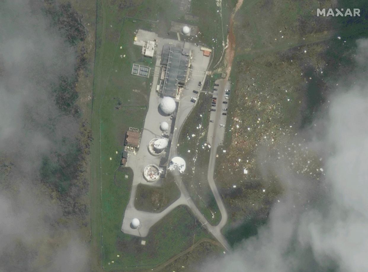
Images show extent of typhoon damage
Saturday 27 May 2023 22:15 , Gustaf Kilander
The U.S. territory of Guam escaped the worst of Super Typhoon #Mawar’s fury. No doubt about it. However, I personally find it very hard to speak of “luck” when I look at some of the damage it left behind. My thoughts are with everyone affected.
Credit: @Maxar pic.twitter.com/OG7K6v29CY— Nahel Belgherze (@WxNB_) May 27, 2023
‘There is still a higher than normal chance for a high impacting hurricane’
Saturday 27 May 2023 21:30 , AP
Scientists don’t even have past years that look the same to help figure out what will happen, Klotzbach and McNoldy said.
So which is going to win between El Nino and the hot oceans?
“I know it’s not a satisfying answer to say ‘we just don’t know,’ but we don’t,” said University of Albany atmospheric sciences professor Kristen Corbosiero.
The pioneer in the field, Colorado State, is predicting a slightly below normal 13 named storms, six hurricanes with two of them becoming major. All but a handful of nearly two dozen private, university and government forecast teams and models call for a near normal Atlantic hurricane season with between six and eight hurricanes.
But they hedge their bets too.
“AccuWeather is expecting a near normal to slightly below normal season due to the onset of an El Nino,” said AccuWeather senior hurricane forecaster Dan Kottlowski, who then added that the warm Atlantic complicates everything. “Due to extensive warm water, there is still a higher than normal chance for a high impacting hurricane to affect the U.S. this season.”
‘The anomalously warm ocean temperatures unquestionably have a human fingerprint on them'
Saturday 27 May 2023 20:45 , AP
Decades of observation show that generally, the Atlantic is quieter with fewer storms during El Nino years. El Nino’s warmer waters make warmer air over the Pacific reach higher up in the atmosphere, influencing winds and creating strong upper-level winds that can decapitate storms, killing them, Colorado State University hurricane researcher Phil Klotzbach said. It’s called wind shear.
El Nino’s effects are not direct and “it’s not as in-your-face as a very warm ocean,” said University of Miami hurricane researcher Brian McNoldy. El Nino and its variations are the single biggest yearly factor in NOAA’s forecast, accounting for up to 38% of its prediction, Rosencrans said.
The Atlantic, especially hugging the African coast to the far east where storms form, is about 1.8 to 3.6 degrees Fahrenheit (1 to 2 degrees Celsius) warmer than the average of the last 30 years and is the warmest it has been for this time of year, Klotzbach said. Warm Atlantic waters not only make storms stronger and more able to withstand El Nino’s shear but they create an opposite direction upper-level wind that could counterbalance El Nino.
“It’s starting to outpace 2010 by a decent margin, which is sobering because 2010 was stinking hot,” Klotzbach said.
“The anomalously warm ocean temperatures unquestionably have a human fingerprint on them,” said former NOAA hurricane scientist Jim Kossin, now of the risk firm The Climate Service.
‘There’s a lot of uncertainty this year'
Saturday 27 May 2023 20:00 , AP
NOAA lead hurricane seasonal forecaster Matthew Rosencrans said at a Thursday news conference: “It’s definitely kind of a rare setup for this year. That’s why our probabilities are not 60% or 70%. There’s a lot of uncertainty this year.”
No matter how many storms brew, forecasters and Federal Emergency Management Agency Director Deanne Criswell reminded U.S. coastal residents from Texas to New England and people in the Caribbean and Central America that it only takes one hurricane to be a catastrophe if it hits you.
“That’s really what it boils down to is: Which is going to win or do they just cancel each other out and you end up with a near-normal season?” said Colorado State University hurricane researcher Phil Klotzbach. “I respect them both.”
The two forces couldn’t be more opposite.
El Nino is a natural temporary warming of the Pacific that happens every few years and changes weather worldwide. Climate models predict as the world warms, El Ninos get stronger.
How busy will Atlantic hurricane season be? Depends on who wins unusual battle of climatic titans
Saturday 27 May 2023 19:15 , AP
Two clashing climatic behemoths, one natural and one with human fingerprints, will square off this summer to determine how quiet or chaotic the Atlantic hurricane season will be.
An El Nino is brewing and the natural weather event dramatically dampens hurricane activity. But at the same time record ocean heat is bubbling up in the Atlantic, partly stoked by human-caused climate change from the burning of coal, oil and gas, and it provides boosts of fuel for storms.
Many forecasters aren’t sure which weather titan will prevail because the scenario hasn’t happened before on this scale. Most of them are expecting a near-draw — something about average. And that includes the National Oceanic and Atmospheric Administration, saying there’s a 40% chance of a near-normal season, 30% chance of an above-average season (more storms than usual) and a 30% chance of a below-normal season.
The federal agency Thursday announced its forecast of 12 to 17 named storms, five to nine becoming hurricanes and one to four powering into major hurricanes with winds greater than 110 mph. Normal is 14 named storms, with seven becoming hurricanes and three of them major hurricanes.
Storm is ‘slightly weakened and is now moving westward'
Saturday 27 May 2023 18:30 , Stuti Mishra and Gustaf Kilander
The Tropical Cyclone now called “Betty” has “slightly weakened and is now moving westward”, The Philippine Atmospheric, Geophysical and Astronomical Services Administration (PAGASA) said in its 5pm local time advisory.
Alerts have been sent out for heavy rainfall in various areas. The forecasted accumulated rainfall ranges from 50-200mm in different regions. Monsoon rains are also likely in the western sections of Mimaropa, Visayas, and Mindanao.
Flooding and rain-induced landslides are possible, particularly in highly susceptible areas and those that have already experienced significant rainfall.
“Betty” is forecasted to track westward in the next 12 hours, then turn west north-westward and eventually become almost stationary near Batanes between late Tuesday and early Wednesday, PAGASA said.
Betty is expected to remain a super typhoon over the weekend, but its strength may weaken due to potentially unfavourable conditions.
“Although it will likely maintain its strength for the next 36-48 hours, short-term intensification is not ruled out, especially in the next 12 to 24 hours,” PAGASA added.
VIDEO: Motorcycle riders struggle through flooded road amid monsoon rain in the Philippines
Saturday 27 May 2023 17:45 , Gustaf Kilander
‘It was the peak that had us questioning our safety'
Saturday 27 May 2023 17:00 , AP
In Yona, winds peeled back the roof of Enrique Baza’s mother’s house, allowing water to damage everything inside. His mother rode out the storm with him at his concrete residence, he said, but “my mom’s house didn’t escape.”
He drove around in a pickup after the storm passed looking for supplies to repair her roof, but most stores were without power and accepting only cash. Many wooden or tin homes were badly damaged or had collapsed outright.
“It’s kind of a shock,” Baza said.
On Friday, President Joe Biden declared that a major disaster exists for Guam and ordered federal aid to supplement recovery efforts.
There were long lines at ATMs and some stores and gas stations on Friday.
Officials said they anticipated being able to resume operations at the flooded A.B. Won Pat International Airport next Tuesday.
Guam Gov. Lou Leon Guerrero gave the all-clear Thursday evening, returning the island to its typical condition of readiness as the National Weather Service lifted its typhoon watch.
“We have weathered the storm,” Leon Guerrero said.
The storm is forecast to continue moving northwest before turning sharply north Tuesday or Wednesday, according to Taiwan’s Central Weather Bureau. That track would keep the typhoon at sea for days as it gradually weakens.
Mawar had regained its status as a super typhoon on Thursday, with winds reaching 150 mph (241 kph). By early Friday, they had strengthened to 175 mph (282 kph), according to the weather service.
On Friday morning, Mawar was centered 345 miles (555 kilometers) west-northwest of Guam and 360 miles (579 kilometers) west of Rota, Guam’s neighbor to the north, moving west-northwest at 14 mph (23 kph).
Carlo Quinonez, who lives near Tamuning, said he rode out the storm in a hotel and felt “very lucky” that the building was largely unscathed. A nearby abandoned building lost many of its windows and part of a wall on the fifth story, Quinonez said.
“It was the peak that had us questioning our safety. Floors rattling and walls creaking. Tossing debris, and roots, and fruit everywhere,” he wrote in an email.
The Navy has ordered the USS Nimitz aircraft carrier strike group to head to the island to assist in the recovery effort, according to a U.S. official. The Nimitz, along with the USS Bunker Hill, a cruiser, and the USS Wayne E. Meyer, a destroyer, were south of Japan and expected to arrive in Guam in three or four days, said the official, who spoke on condition of anonymity to discuss ship movements not yet made public.
