Two tropical weather systems could develop. What forecast says on those and hurricanes
As if to say, “Look at me, hurricane season isn’t over until Nov. 30,” two new disturbances formed Thursday in the Atlantic to join Tropical Depression Lisa.
According to Colorado State University meteorologist Philip Klotzbach, Wednesday’s activity from Martin and Lisa was the first time since 1932 in which the Atlantic had two hurricanes with maximum sustained winds of 85 or more mph in November simultaneously.
For the first time since 1932, the Atlantic has two #hurricanes with max winds of >=85 mph in November simultaneously. #Lisa and #Martin currently both have max winds of 85 mph. pic.twitter.com/NBNf9YFapw
— Philip Klotzbach (@philklotzbach) November 2, 2022
Here’s what we know:
Northwestern Atlantic
A weak, non-tropical area of low pressure several hundred miles east-southeast of Bermuda (the yellow X on the map) was shedding disorganized showers and thunderstorms over open waters, according to the National Hurricane Center’s Friday morning advisory.
Any subtropical or tropical development of the disturbance should be slow over the next couple of days as it moves little through Friday and then turns west over the weekend.
By the end of the weekend, the disturbance is expected to merge with a larger system developing to its southwest (the yellow blob on the map), and that should stymie further development. Formation chances at two and five days are low at 10%.
Hurricane #Martin Advisory 9: Large and Powerful Martin Forecast to Become Post-Tropical Over The Central North Atlantic Within the Next Few Hours. https://t.co/tW4KeFW0gB
— National Hurricane Center (@NHC_Atlantic) November 3, 2022
Southwestern Atlantic
The larger system that could merge with the northwestern Atlantic non-tropical area is a large non-tropical low pressure system that hurricane center forecasters expect to develop this weekend over the northeastern Caribbean Sea and southwestern Atlantic.
The system is expected to start out very broad and disorganized, but environmental conditions could support gradual subtropical or tropical development beginning early next week while it moves northwest or west.
Formation chance over the weekend is at zero but over five days there could be a 30% chance for development.
According to WPLG meteorologist Michael Lowry, this “big sloppy weather system” could “pinwheel toward Florida’s peninsula” next week.
“The system may try to acquire tropical characteristics gradually but given the large, gyre-like circulation and nearby upper-level low, this process would take some time. Regardless, the contrast of high pressure to the north and such a large area of low pressure to the south will mean breezy weather, high surf, and the potential for rain squalls across South Florida beginning early next week,” Lowry wrote on his Eye on the Tropics blog.
A November to remember in the tropics: Lisa's destructive storm surge, the messy system shaping up for next week, and the highest-latitude November hurricane on record in the Atlantic.https://t.co/bfBiS5hCIP
— Michael Lowry (@MichaelRLowry) November 3, 2022
Tropical Depression Lisa
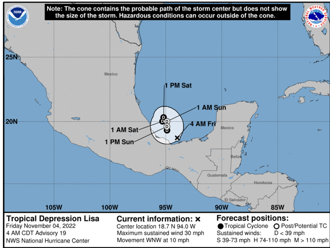
The former hurricane was emerging over the Bay of Campeche Friday morning and was about 145 miles west of Ciudad Del Carmen, Mexico, according to the hurricane center’s 5 a.m. advisory. Maximum sustained winds remain near 30 mph with higher gusts.
While Tropical Depression Lisa could still bring an additional one to two inches of rain early Friday across portions of southeastern Mexico, its rain is beginning to diminish, forecasters said.
On the forecast track, Lisa could see some slight strengthening during the next 24 hours as it moves west-northwest near 10 mph before weakening and degenerating into a remnant low pressure area by Sunday, according to the hurricane center.
Miami Herald staff writer Michelle Marchante contributed to this report.
