Will the tropical wave that Florida is watching develop? What the forecast shows
The Atlantic basin remains crowded Thursday morning, with forecasters monitoring five systems:
▪ A disturbance Florida is closely watching in the Caribbean Sea that has a high chance of turning into a tropical depression in the next couple of days.
▪ Two systems are in the eastern Atlantic, one of which could be a tropical depression this weekend.
▪ And there’s Hurricane Fiona and Tropical Storm Gaston, neither of which is a threat to Florida or the rest of the United States.
Here’s a forecast breakdown:
Disturbance in the Caribbean
The tropical wave off the coast of Venezuela that models suggest could blow up into a hurricane in the Caribbean later this week was struggling to form a defined center on Thursday. Radar images showed the beginnings of a swirl, but mostly a disorganized system.
It was battling leftover wind shear from Category 4 Hurricane Fiona, which ripped through Puerto Rico and the Dominican Republic this week, and was so close to Venezuela Thursday afternoon that it was half on land — slowing down development.
At this point, the National Hurricane Center expects those impediments to fade away in the next few days, allowing the wave to develop into a tropical depression or storm someplace in the western Caribbean.
“The upper-level wind environment over the low is expected to become more conducive for development, and a tropical depression is expected to form during the next day or two while moving west-northwestward at 10 to 15 mph across the central Caribbean Sea,” the hurricane center said in its advisory at 8 p.m.
The hurricane center Thursday afternoon upped the system’s formation chances from 70% to 90% through the next 48 hours and a 90% chance within the week.
In its advisory, the hurricane center notes: “Locally heavy rainfall and gusty winds are likely to affect northwestern Venezuela, the ABC island chain, and northeastern Colombia through Friday. Interests in Jamaica and the Cayman Islands should closely monitor the progress of this system.”
“That’s as far as we go at this point,” acting director of the hurricane center, Jamie Rhome, said in a Thursday morning broadcast. “There’s been a lot of speculation about what this storm might do if it were to get into the Gulf of Mexico. It’s too soon to speculate out that far in time.”
The latest rounds of computer models continue to show possible paths for the future storm that stretch from the Yucatan Peninsula to Florida’s Panhandle, although they are far less confident than the predictions for what the potential storm could do in the short term.
READ MORE: What those hurricane spaghetti models all over social media actually mean
The GFS American model, for example, takes the system into the west-central Gulf of Mexico next week, which would be good for South Florida, NBC6 Meteorologist Adam Berg said on Twitter. Berg said that the European model, on the other hand, brings the system closer to Florida, which would bring more rain and breezes to the region.
“Until the models agree, our confidence is low when it comes to South Florida Impacts,” Berg tweeted.
The GFS (American) model takes our new tropical system into the west-central #GulfofMexico next week. This would be good for South Florida. Until the models agree, our confidence is low when it comes to South Florida Impacts. Stay with @nbc6https://t.co/PKdbgxwLAa pic.twitter.com/ast8m572ak
— Adam Berg (@AdamBergNBC6) September 22, 2022
Meanwhile, the European global model brings #Invest98L (our next tropical system) on a closer path to #Florida. This track would bring more rain and breeze to our area. Too early to make call. Keep it tuned to @nbc6 and https://t.co/gWIYfbYt58 pic.twitter.com/Hw4qc8ejFs
— Adam Berg (@AdamBergNBC6) September 22, 2022
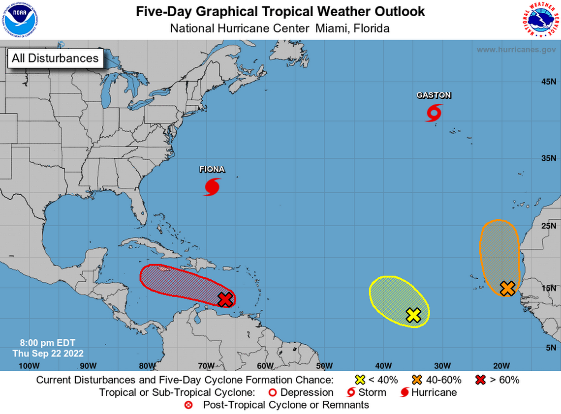
What about the disturbances in the eastern Atlantic?
The hurricane center is monitoring two disturbances in the eastern Atlantic. One system has emerged from Africa’s west coast into the Atlantic’s warm waters. And another is several hundred miles west-southwest of the Cabo Verde Islands.
Forecasters say the disturbance near the African coast could turn into a tropical depression this weekend as it slowly moves north, between west Africa and the Cabo Verde Islands. The hurricane center says it has a 60% chance of formation in the next two to five days.
The other system could see some development as it moves northwest or north over the Atlantic and has a 20% chance of formation in the next 48 hours and a 30% chance of formation through the next five days.
Hurricane Fiona
Hurricane Fiona, a large Category 4 storm, was quickly moving north-northeast over the Atlantic on Thursday night with maximum sustained winds near 130 mph and higher gusts. Its hurricane-force winds extended up to 115 miles and tropical-storm-force winds extended up to 275 miles — a huge jump from the afternoon.
As of the hurricane center’s 11 p.m. Thursday advisory, Fiona was about 195 miles west of Bermuda and roughly 910 miles south-southwest of Halifax, Nova Scotia.
Tropical storm conditions have already begun in Bermuda; the island expects to see hurricane conditions overnight.
The forecast shows Fiona making its closest approach just to the west of Bermuda overnight into early Friday morning. The island is under a hurricane warning.
Fiona weakening sometime Thursday night or Friday into a Category 3 hurricane with maximum sustained winds of 125 mph, according to the forecast.
Forecasters expect the storm will still “be a large and powerful post-tropical cyclone with hurricane-force winds when it moves over Nova Scotia Friday night and Saturday.”
Hurricane and tropical storm watches were issued for much of Atlantic Canada on Thursday. Parts of Canada may start feeling Fiona’s hurricane and tropical storm-force winds by late Friday.
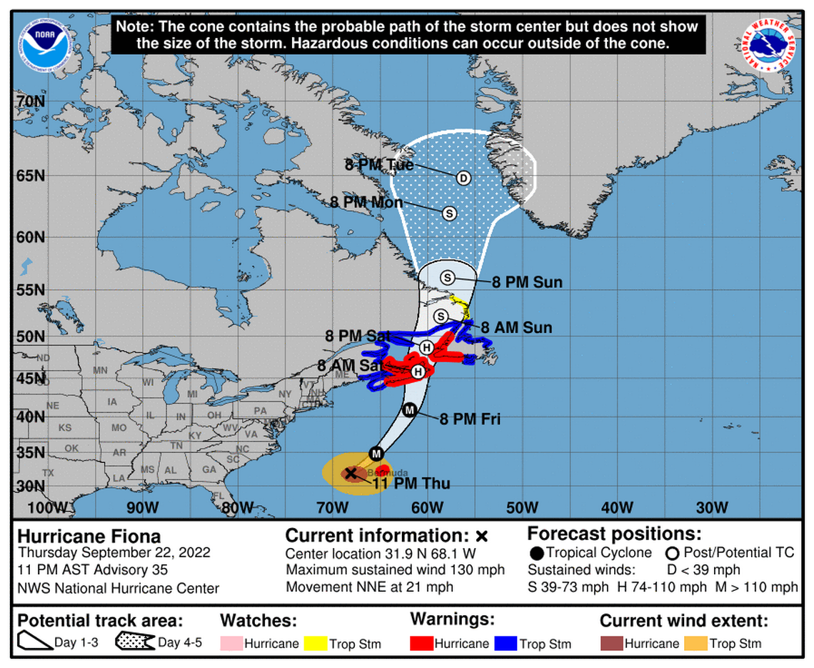
The hurricane center says Bermuda will see two to four inches of rain, with storm surge expected along part of its coast starting Thursday night. Fiona’s swells are also continuing to affect the Turks and Caicos Islands, the Bahamas, the southeastern United States coast, and have now reached Bermuda.
“These swells will continue to spread northwestward across the western Atlantic toward the mid-Atlantic and northeast coasts of the United States and Atlantic Canada tonight and on Friday. These swells are likely to cause life-threatening surf and rip current conditions,” the hurricane center said.
READ NEXT: How much damage did Hurricane Fiona do to Puerto Rico? Videos, photos show destruction
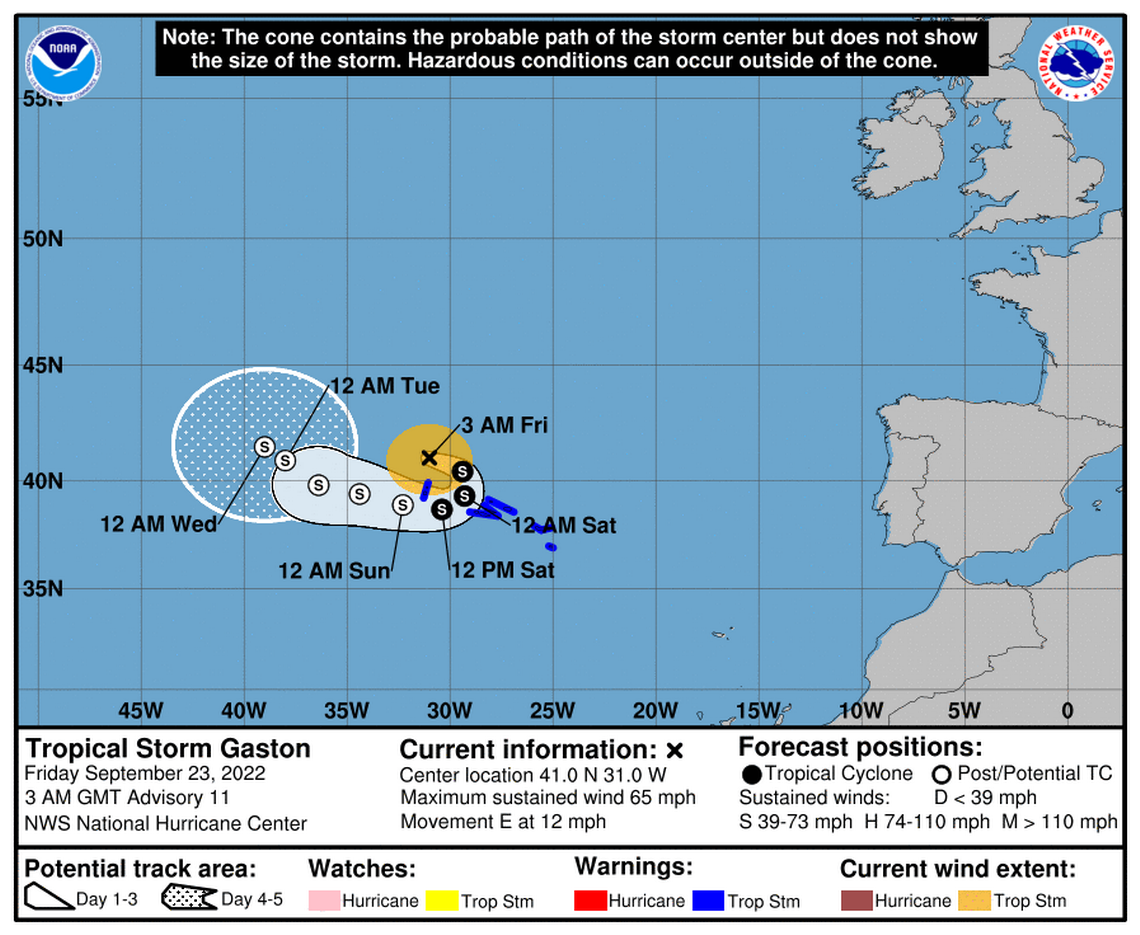
Tropical Storm Gaston
Tropical Storm Gaston was approaching the western Azores with maximum sustained winds of 65 mph and higher gusts Thursday night, according to the hurricane center’s advisory at 11 p.m.
Gaston has slowed down to 12 mph and is forecast to make a turn to the east. Gaston’s center is expected to move near or over portions of the Azores Thursday night through Saturday.
Parts of the Azores are under a tropical storm warning.
The hurricane center expects Gaston to weaken in the next few days and then make a “clockwise loop along the southern side of a blocking mid-level ridge.”
Forecasters expect it will turn into a post-tropical system in the next few days as it remains in an environment of dry air and is influenced by “strong westerly shear.”
What are the next storm names?
Hermine and Ian are the next storm names on the list for the 2022 Atlantic hurricane season.
