Forecast for Ian upgraded to a tropical storm warning in the Midlands
Hurricane Ian regained strength Thursday afternoon, returning to hurricane status after being downgraded to a tropical storm earlier in the day,, and it’s forecast to bring severe weather to the Columbia area, according to the National Weather Service.
A previously issued tropical storm watch was upgraded to a tropical storm warning for the Midlands, as powerful winds from 39 to 57 mph are possible, and gusts could exceed 60 mph, the National Weather Service said.
A tropical storm warning means tropical storm-force winds are expected in the area within the next 36 hours, opposed to a watch, which indicates severe weather is a possibility, but not currently happening.
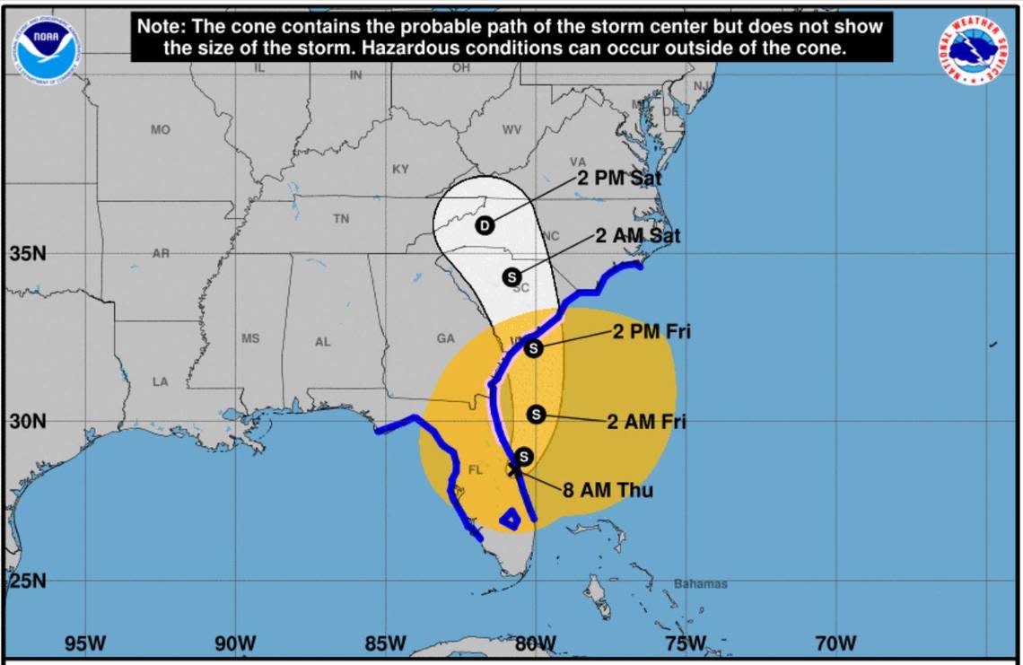
There is still some uncertainty on the final track and strength once Ian reaches the Midlands, but it will cross some part of the area, the National Weather Service said. As of 11 a.m. Thursday, Ian was forecast to be a tropical storm when it tracks near Columbia in the Hartsville area at about 8 p.m. Friday, according to the National Hurricane Center.
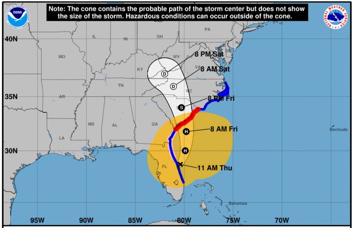
Forecasters believe Ian will make landfall somewhere near Charleston as a Category 1 hurricane, according to the South Carolina Emergency Management Division.
“If you haven’t yet made plans for every contingency, this afternoon is the time to do so,” S.C. Gov. Henry McMaster said Thursday in a news release.
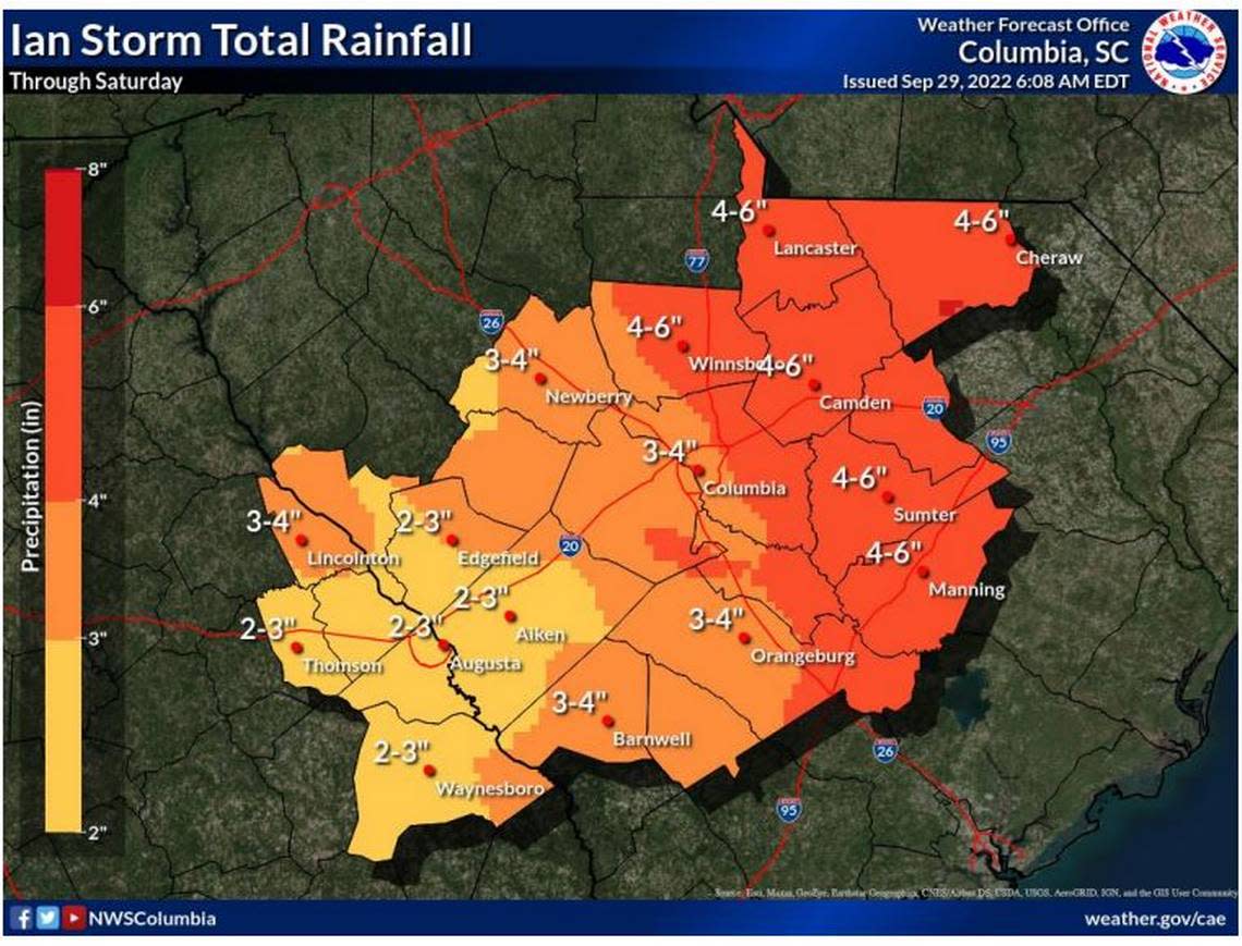
The greatest threat Ian poses to the Columbia area is heavy rain and flash flooding, National Weather Service meteorologists said in a Thursday morning briefing. Up to 6 inches of rain could fall across the Midlands, and the amounts of rain could be heavier locally, according to the National Weather Service.
Although the potential for tornadoes is low, the threat of some forming has not been ruled out by the National Weather Service.
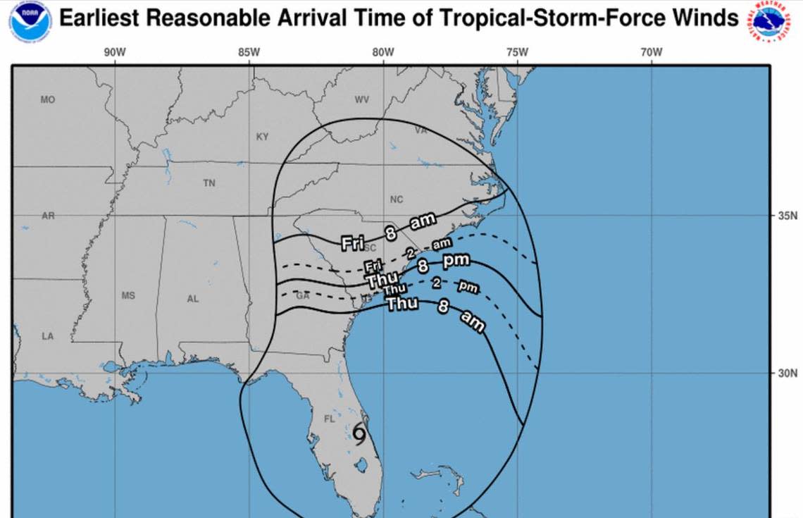
After causing extensive damage in Florida, Ian has moved east of the Florida coast and is slowly heading northwest toward the Midlands, according to the briefing. The greatest impacts to the Columbia area are expected Friday through Saturday morning, meteorologists said.
Tropical storm force winds are most likely to hit the Midlands Friday, and the heaviest rain will fall that same time and on Friday night, according to the briefing. Windy conditions are already affecting the Columbia area and rain could start Thursday night, the National Weather Service said.
Powerful winds and tornadoes could cause considerable damage to trees and branches, in addition to mobile homes, roofs and outbuildings. Vehicles would also be under siege in the case of a tornado.
Damage to trees and branches creates the possibility of downed power lines and outages.
Forecasters with the National Hurricane Center believe Ian will be near hurricane strength when it approaches South Carolina and then weaken Friday night into Saturday as it moves across the state, according to the state’s Emergency Management Division.
McMaster has declared a state of emergency in South Carolina, but is not ordering evacuations or demanding that government buildings or schools close. Most Columbia-area school districts decided to close buildings and hold classes online Friday.
The South Carolina Emergency Operations Center moved to Operational Condition Level Two, meaning disaster or emergency is likely to affect the state, and emergency operations plans are implemented.
“While we will not see the full force of Hurricane Ian the way Florida did, we could see high winds, rain, flash flooding and even tornadoes,” S.C. Emergency Management Director Kim Stenson said Thursday in a release. “Flooding due to storm surge and rain could be a major concern. Over the next day, it will be vital for everyone to be prepared to act if told to do so by your local public safety officials.”
This will be the first named storm to hit the Columbia area since the remnants of Tropical Storm Fred washed through in August 2021, according to National Weather Service meteorologist Pierce Larkin.
Ian is the fourth Atlantic hurricane of the season, and the first to make landfall in the continental U.S.
There’s an 90% chance of rain on Friday, dropping significantly on Saturday, according to the forecast. More rain is possible on Sunday and Monday, but it’s even less likely, the forecast shows.
As of 5 a.m. Thursday, Ian was about 400 miles south of Columbia, the National Weather Service said. By 11 a.m., Ian was moving northeast at 9 mph, and had maximum sustained winds of 70 mph, according to the National Hurricane Center.
Tropical-storm-force winds extend outward up to 415 miles from the center of Ian, the National Hurricane Center said.
“Ian is forecast to produce life-threatening flooding, storm surge, and gusty winds across portions of Florida, Georgia and the Carolinas,” the National Hurricane Center said.