Tropical storm warning, hurricane watch issued for Florida’s east coast ahead of Nicole
Much of Florida’s east coast could see high winds, rain and coastal flooding this week as Subtropical Storm Nicole approaches the state for a midweek landfall.
Forecasters at the National Hurricane Center said Nicole could still become better organized before it strikes the coastline, possibly as a tropical storm or even a Category 1 hurricane. But either way, the potential for power outages, beach erosion and flooding worsened by king tides remains the same.
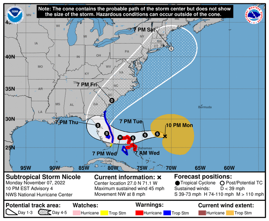
A tropical storm warning was issued from Hallandale Beach in Broward County to Altamaha Sound, Georgia, the hurricane center said Monday in its 10 p.m. advisory. Lake Okeechobee is also under a tropical storm warning.
The hurricane center also upgraded the storm surge watch to a storm surge warning from North Palm Beach north to Altamaha Sound, including the mouth of the St. Johns River in Jacksonville to Georgetown.
A hurricane watch is in effect for Florida’s east coast from the Volusia-Brevard county line to Hallandale Beach, and Lake Okeechobee. And the area from Hallandale Beach to north of Ocean Reef — including Miami-Dade County — is under a tropical storm watch.
Forecasters said Nicole was expected to make landfall overnight Wednesday, but high winds, flooding and storm surge could pick up earlier in the day.
East coast counties like Broward and Miami-Dade opened up sandbag distribution on Monday, and some warned that evacuations might be necessary. Some athletic fields and parks planned closures for the storm, and a growing list of events have been canceled or rescheduled, but officials don’t expect any disruption to Election Day plans on Tuesday.
On Monday afternoon Gov. Ron DeSantis declared a state of emergency in 34 Florida counties, many in South Florida, and warned residents and visitors to keep a close eye on the forecast.
“While this storm does not, at this time, appear that it will become much stronger, I urge all Floridians to be prepared and to listen to announcements from local emergency management officials,” DeSantis said in a statement.
Jamie Rhome, acting director of the National Hurricane Center, said in a Monday morning broadcast that Floridians should be prepared for a low-end hurricane to a high-end tropical storm. Preparations should be done by sundown Tuesday for east coast residents, he said.
“Not an Ian situation, but still a potentially impactful situation,” Rhome said. “Florida residents need to be paying attention.”
Rain and flooding in the forecast
As of 10 p.m. Monday, Nicole had sustained winds of 45 mph, and was moving northwest at 8 mph, a slowdown from the morning. The storm was about 415 miles east-northeast of the northwestern Bahamas. Nicole is currently a subtropical storm but is expected to transition into a tropical storm, a distinction that is largely academic, although subtropical storms usually have a larger wind field and form over cooler waters.
Nicole was expected to make a sharp left turn toward the Bahamas and Florida in about three days, and it could batter Florida’s east coast with tropical-storm-strength winds, heavy rain and damaging storm surge. Forecasters said the broad wind field, mostly packed to the north of the storm, could consolidate as Nicole creeps closer, delivering a stronger storm.
Florida is under a hurricane and storm surge watch. What should you be doing right now?
The tropical storm watch for the northwestern Bahamas, including Andros Island, New Providence, Eleuthera, Abacos Islands, Berry Islands, Grand Bahama Island and Bimini, was upgraded to a hurricane warning Monday afternoon. The Bahamas could see up to six inches of rain and three to five feet of storm surge from Nicole, the hurricane center said.
At a press conference on a breezy Monday afternoon outside County Hall, Miami-Dade Mayor Daniella Levine Cava said she does not intend to alter Election Day plans Tuesday ahead of Nicole. All precincts plan to remain open until the planned closing time at 7 p.m. Though some gusty showers are predicted Tuesday evening, Levine Cava said no forecast suggests anything serious enough to change elections logistics. “We’re used to rain,” she said.
Should Miami-Dade receive tropical-storm winds, they would likely arrive Wednesday morning, according to the 4 p.m. forecast from the National Hurricane Center.
Under the current forecast, Levine Cava said the county’s transit system didn’t expect the suspension of service required when sustained winds cross the tropical-storm threshold at 39 mph.
That could change as the storm approaches. Miami-Dade transit administrators didn’t think winds would be strong enough during Hurricane Ian to affect service, then announced suspension of bus, Metrorail and Metromover operations in the middle of the night on Sept. 28 when conditions changed.
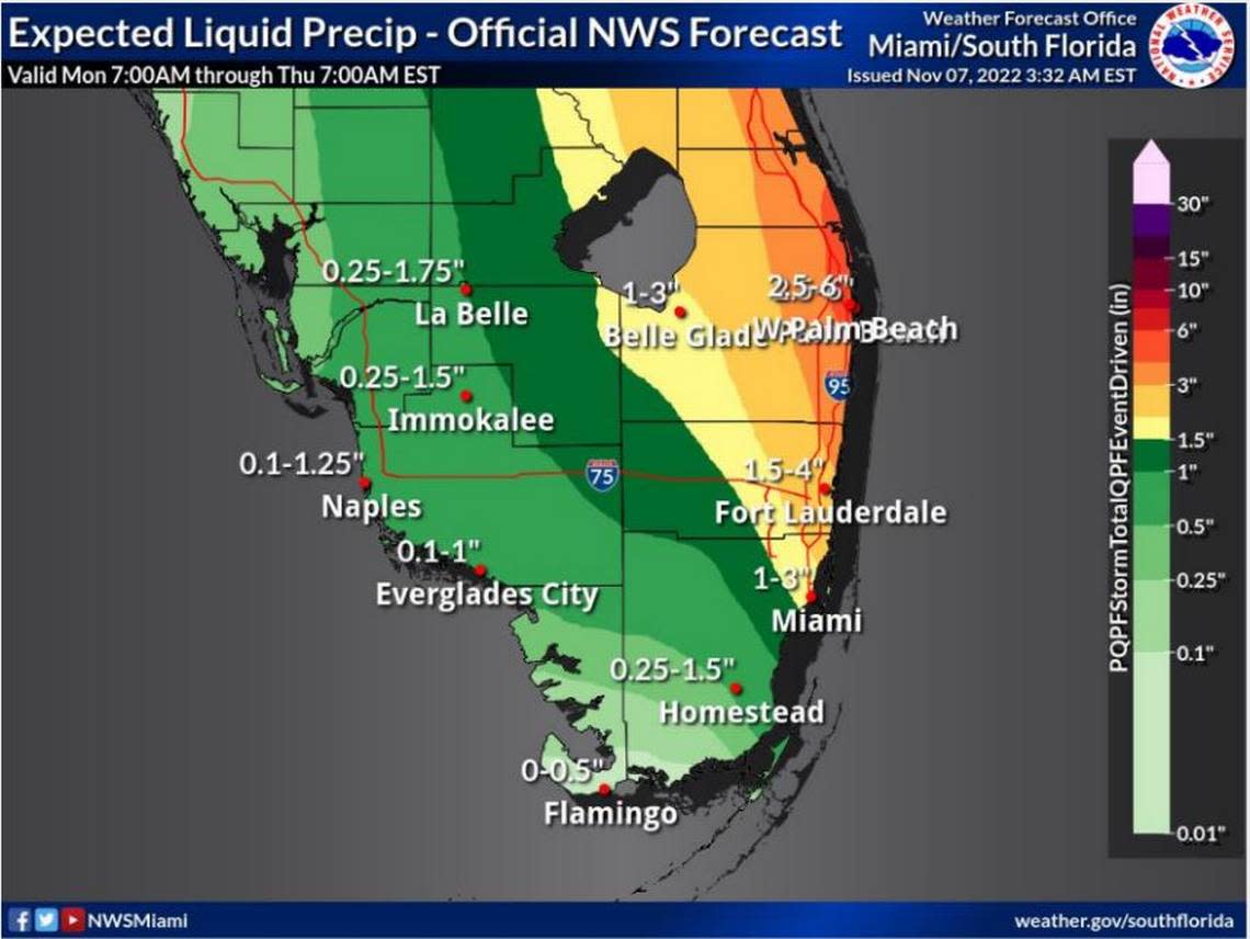
As of noon Monday, the Miami office of the National Weather Service said South Florida could see up to four to six inches of rain through Friday, mostly in coastal Palm Beach County and Broward. Fort Lauderdale could see up to four inches, and Miami could see up to three inches.
Tuesday is also the peak of the latest king tide, the highest annual tide of the year. The combination of higher-than-average tides and winds pushing onshore could lead to extensive flooding in South Florida.
The hurricane center issued a storm surge warning for much of Florida’s east coast, with up to three to five feet expected from North Palm Beach to Altamaha Sound. Hallandale Beach to North Palm Beach could see two to four feet, and Biscayne Bay could see one to two feet of storm surge.
Levine Cava said forecasts so far are manageable for Miami-Dade.
“We’re expecting, right now, perhaps a one- or two-foot surge,” she said. “Which of course is a concern, but not a great concern. We think we can manage it appropriately.”
When will Miami and the rest of Florida feel Subtropical Storm Nicole’s rain and wind?
Rhome, the hurricane center director, said he was particularly worried about the threat to northeast Florida in areas that saw intense dune erosion from Hurricane Ian a few months ago. Sand dunes and beach sand are the front line of defense against storm surge.
“The dunes have been severely eroded. The potential for coastal flooding, possible, possible life-threatening flooding, certainly exists,” he said.
READ MORE: Could Owen join Subtropical Storm Nicole in the Atlantic? What the forecast shows
What the spaghetti models show
Computer models are largely in agreement that Nicole will hook left, cross the northern Bahamas and make landfall on Florida’s east coast sometime this week. Exactly where isn’t a done deal yet, but it’s less important for a subtropical storm like Nicole, since the area of high winds surrounding the storm is much broader than tropical storms usually are.
As of the 11 p.m. forecast, Nicole’s center is expected to make landfall near Port St. Lucie, with the majority of strong winds and flooding risk to the north.
From there, Nicole’s zigzag path across Florida is somewhat uncertain.
Fresh Monday afternoon spaghetti models on Nicole. The cluster is tightening up. Hurricane is expected as NHC has Hurricane Watches up for parts of Florida and the Bahamas. Pressures showing in the 970's to 990's range around landfall. https://t.co/Hk3pbO84Yf pic.twitter.com/AQ4HvIgihk
— Mike's Weather Page (@tropicalupdate) November 7, 2022
The hurricane center predicts the storm will tack northwest, before abruptly turning north in the area of Citrus County and crossing south of Gainesville. It’s expected to then pass north of Jacksonville before heading toward Georgia.
Spaghetti models, those clustered lines on a map showing where weather supercomputers predict the storm will head, are packed tightly together, suggesting high confidence in the prediction.
What those hurricane spaghetti models all over social media actually mean
They differ slightly on where exactly Nicole will come ashore in Florida, and some show the storm curving north without exiting into the Gulf Coast at all. Others suggest the storm could curve out into the Gulf a little farther before heading back toward the north end of Florida.
Miami Herald editor Jeff Kleinman and Miami Herald staff writers Charles Rabin, Douglas Hanks and Omar Rodríguez Ortiz contributed to this article.
