Tropical Storm Tammy likely to develop over the Atlantic


AccuWeather hurricane experts continue to monitor a cluster of showers and thunderstorms in the central Atlantic, which could soon become the next named tropical system in the Atlantic basin.
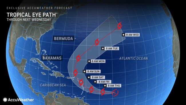
The tropical wave, designated as Invest 94L by the National Hurricane Center (NHC), will continue to shift westward across the central Atlantic and is expected to become more organized throughout the week. AccuWeather experts are giving this wave a high chance of developing into a tropical storm at any time over the next couple of days and have dubbed the system a tropical rainstorm to raise public awareness of the risk to lives and property.
Should this wave strengthen into a tropical storm, it would be named Tammy, becoming the 19th named storm of the season. Only two names will remain on the seasonal list after that, then an alternate list of names selected by the World Meteorological Organization (WMO) will be used to name organized systems.
 |
Steering flow in the Atlantic is expected to remain steady through midweek, guiding the system to the west like the track that former Tropical Storm Sean followed last week. By late week into the weekend, an area of high pressure located over the northern Atlantic will be the main factor behind steering flow across the basin. Depending on the exact location of high pressure, the storm could either stay to the south moving toward the Lesser Antilles or make a northerly turn and remain over the ocean.
However, the system is already farther south than Sean was, and that may lead to impacts from drenching showers and gusty thunderstorms in the eastern Caribbean, which Sean failed to do.
 |
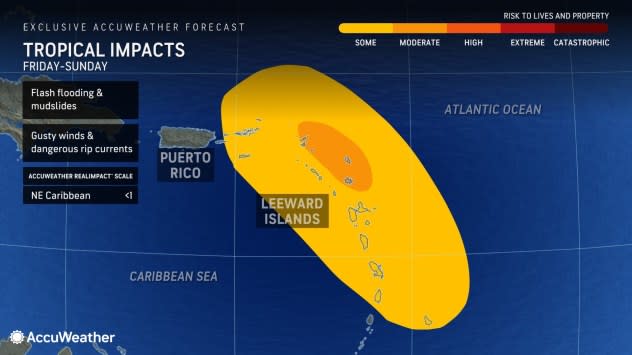
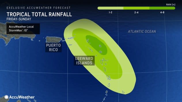
AccuWeather meteorologists have rated the system as "less than one" on the AccuWeather RealImpact™ Scale for Hurricanes, which is a six-point scale ranging from "less than one" and 1 to 5. There is the likelihood of heavy rain, which could lead to incidents of flash flooding, mudslides and washouts in the Lesser Antilles, especially across the Leeward Islands of the northeastern Caribbean from Friday to Sunday.
Wind gusts of 40-60 mph are likely in the Leeward Islands. Sporadic power outages and downed trees are possible with winds of that magnitude. The AccuWeather Local StormMax™ wind gust in the Leeward Islands is predicted to be 75 mph, which is just above the minimum threshold of a hurricane.
 |
The 2023 Atlantic hurricane season has been busy so far with 18 named storms in the books. About a month and a half remains for the official season, which ends on Nov. 30. This season has been above the historical average in terms of named storms. During an average hurricane season, only 14 named storms form across the basin.
Six of the named storms so far in 2023 became hurricanes, and three strengthened into major hurricanes, which are at least Category 3 storms with sustained winds of 111 mph or higher.
The strongest hurricane so far this season was Hurricane Lee, which reached Category 5 strength with winds of 165 mph over the central Atlantic. Lee made landfall on Sept. 16 as a tropical wind and rainstorm in western Nova Scotia, bringing heavy rain and damaging winds to parts of New England and Atlantic Canada.
 |
AccuWeather Enhanced RealVue™ Satellite view of Invest 94L captured on Wednesday, Oct. 18, 2023. |
The Atlantic has been outpacing the East Pacific regarding tropical development, which is rather unusual for an El Niño year. As of Tuesday evening, the Atlantic has had two more storms, including named and unnamed systems and subtropical storms, than the Pacific. An El Niño phenomenon occurs when water temperatures in the central and eastern Pacific near the equator climb above historical averages for months at a time.
The pattern typically favors more tropical activity in the eastern Pacific due to warm ocean water, which acts as fuel for tropical systems, and it can also suppress tropical development at times over the Atlantic due to an increase in the frequency of disruptive wind patterns over the basin.
From 1971 to 2020, there were 16 hurricane seasons in an El Niño pattern, and of those, only three generated more storms in the Atlantic than in the East Pacific: 1972, 1976 and 1977. It has been 46 years since that occurred, according to AccuWeather Senior Meteorologist and Manager of Forecasting Technology Michael Doll.
Want next-level safety, ad-free? Unlock advanced, hyperlocal severe weather alerts when you subscribe to Premium+ on the AccuWeather app. AccuWeather Alerts™ are prompted by our expert meteorologists who monitor and analyze dangerous weather risks 24/7 to keep you and your family safer.
