Tropical Storm Earl brings floods to Puerto Rico. Hurricane Danielle strengthens
The United States’ mainland East Coast has little to worry about from the hurricane, the tropical storm or, for now, the third system that’s in the Atlantic Ocean, according to the National Hurricane Center.
But people in the American territories of Puerto Rico and the U.S. Virgin Islands experienced downpours, strong wind gusts and flooding on Sunday.
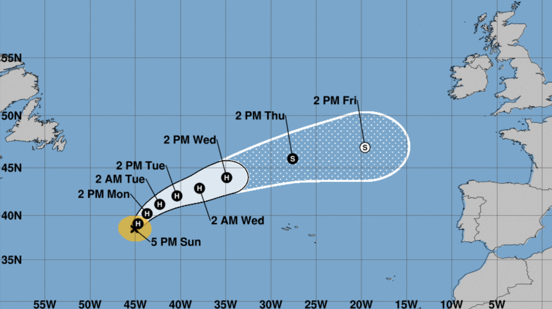
Hurricane Danielle
Hurricane Danielle is in the northern mid-Atlantic gradually strengthening and turning northward, according to a 5 p.m. NHC advisory.
Danielle has caused no hurricane watches or warnings and theadvisory lists no threats to land. Maximum sustained winds were at 85 mph, extending 25 miles from the center with tropical storm force winds as far as 105 miles.
The Category 1 hurricane was 980 miles west of the Azores, slowly moving north at 2 mph.
Over the next few days, Danielle is projected to head northeast, maxing out Monday with 90 mph winds before gradually weakening over the next few days.
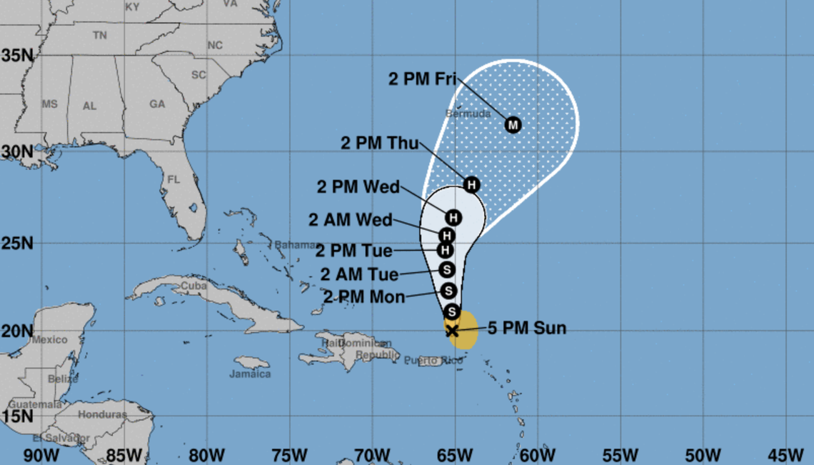
Tropical Storm Earl
The National Weather Service in San Juan warned Puerto Ricans on Sunday afternoon about heavy rains, mudslides and life-threatening flash flooding of streams, highways and streets — urging the public to avoid traveling on flooded roads.
U.S. Coast Guard crews rescued a spear fisherman clinging to rocks in U.S. Virgin Islands waters on Sunday amid Tropical Storm Earl’s six-foot waves, helicopter footage showed. A man and a woman riding a jetski Sunday near the Puerto Rican southern town of Salinas died after being struck by lightning, the local newspaper Primera Hora reported in the afternoon.
READ MORE: Watch crews rescue fisherman from Tropical Storm Earl’s waves off U.S. Virgin Islands
At 6:40 p.m., showers and thunder storms had diminished in land areas, but some river gages were indicating that water levels were still high with some urban and small stream flooding being reported, the NWS said on Twitter.
Earl was about 110 miles north of St. Thomas, one of two main islands of the U.S. Virgin Islands, moving slowly northwest with 50 mph winds, according to the 5 p.m NHC advisory. Tropical storm force winds were extending 105 miles from Earl’s center.
“Slow strengthening is forecast over the next several days, and Earl could become a hurricane later this week,” the advisory said.
Earl is expected to turn north-northwest Monday and north-northeastward later this week, turning into a Category 2 hurricane with 105 mph winds in five days.
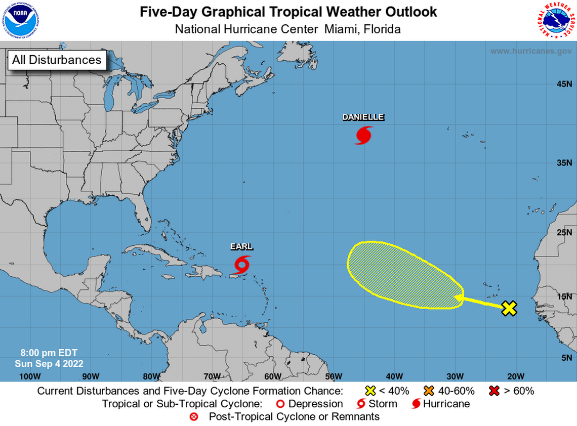
Tropical wave off Africa’s coast
A tropical wave between the west coast of Africa and the Cabo Verde Islands is producing some disorganized shower and thunderstorms, the NHC said Sunday in an 8 p.m advisory. An area of low pressure could form, and gradual development is possible as it moves generally west-northwestward over the eastern and central tropical Atlantic during the next several days.
It had nearly 0% chance of formation in the 48 hours, the NHC said, and a low 20% through the next five days.