Tropical Atlantic may soon stir from its weeks-long slumber


 |
This image was taken on Wednesday morning, Aug. 10, 2022, and shows tropical waves (dashed lines). A robust tropical wave was located over the middle of the Atlantic (right of center). |
After spawning three early season storms, the Atlantic hurricane season screeched to a halt six weeks ago, but AccuWeather forecasters say there are signs of life as they monitor a couple of areas in the basin for potential tropical development.
A batch of thunderstorms moving westward over the tropical Atlantic will continue to be monitored for organization and strengthening through the rest of this week, and an anticipated broad zone of unsettled conditions along the Southeast coast of the United States could be another potential trouble spot next week.
AccuWeather meteorologists have been monitoring a tropical disturbance, known as a tropical wave, since it moved across Africa last week and then over the Atlantic this past weekend. Early this week, the National Hurricane Center (NHC) dubbed the system Invest 97L to assist with tracking the feature's progress.
The tropical wave was moving west-northwestward at about 17 mph as of Thursday, and there has been no organization to the showers and thunderstorms which would indicate that a circulation has developed.
Steering breezes will tend to guide the system on a westerly course this week with a slight turn toward the northwest this weekend due to the clockwise circulation around a large area of high pressure over the middle of the Atlantic that meteorologists refer to as the Bermuda High.
As of Thursday, the 97L remained in a small pocket of moisture that was surrounded by dry air -- a factor that could favor possible development. Dry air and dust, on the other hand, tend to inhibit tropical development.
 |
This water vapor image of the tropical Atlantic from Wednesday, Aug. 10, 2022, shows dry air in shades of orange and red and moist air in shades of gray, blue and green. |
Another weather element that supports formation of an organized tropical system was falling into place. The tropical wave was in a zone of relatively low wind shear. Strong wind shear can prevent tropical storm formation and can sometimes cause an established tropical storm to weaken.
Due to these two favorable conditions in the system's environment among other factors, AccuWeather meteorologists believe there is a low chance the tropical wave will strengthen into a tropical depression or storm. However, in the coming days, the system will encounter a harsher atmosphere for tropical development.
If it doesn't become better organized into a tropical depression or storm by late in the week or the weekend, then it may miss its window to develop, AccuWeather forecasters say.
 |
"If 97L does not develop a core through Thursday, it will have to fight off increasing shear and dry air without a solid circulation feature," AccuWeather Hurricane Expert Dan Kottlowski said. "This kind of situation tends to kill off a fledgling system entirely."
Impacts are anticipated whether the system is named or not. Gusty showers and thunderstorms associated with the disturbance are likely to swing through the Leeward Islands in the northwestern part of the Caribbean beginning on Sunday. Puerto Rico and the Virgin Islands will be next to feel its impacts by Monday, then the Bahamas will endure stormy conditions spanning Tuesday and Wednesday.
If the storm manages to beat the odds and battle shear and dry air, then the system could become stronger and more compact. In that case, it may turn northwestward sooner, potentially avoiding the Leeward Islands.
The chance of tropical development with this feature is very low this weekend and next week, but it cannot be written off entirely.
"Should the system manage to survive the wind shear zone, or if wind shear was to ease, there could still be development somewhere near the Bahamas and the Florida Keys toward the middle of next week," AccuWeather Long-Range Meteorologist Paul Pastelok said.
The zone along the southeastern Atlantic and Gulf coasts of the United States may be a general ultra-low-risk area for tropical development next week.
 |
"A stalled front along the Southeast coast can lead to flare-ups of thunderstorm activity from the Gulf of Mexico to the Southwest Atlantic next week," Pastelok said. "A weak disturbance bred from thunderstorms would have to get far enough away from the front and wind shear zone for any type of tropical development to take place, but it is something to watch."
Despite those concerns, conditions are likely to remain less than ideal for rapid tropical storm formation and strengthening over the next week or so. While waters continue to warm all summer, vast areas of wind shear, dry air and dust often inhibit tropical activity during the middle of the season.
AccuWeather meteorologists are examining the potential that these same inhibiting factors may linger into the late summer and autumn.
"While La Niña conditions (cool water) over the tropical Pacific generally lead to above-average numbers of tropical storms and hurricanes in the Atlantic, the global pattern-changing effects from La Niña, now in its third year, may be diminishing," Kottlowski said.
 |
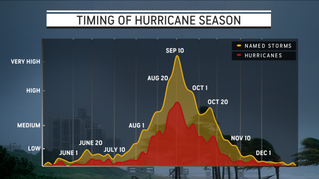
Even though there may be hurdles for burgeoning tropical systems, AccuWeather forecasters warn that the bulk of the Atlantic hurricane season looms and direct impacts on the U.S. are still anticipated.
Thus far, there have been three tropical storms this season. Of the three, Alex and Colin directly impacted the U.S. Bonnie tracked into Central America and moved on into the Pacific, where it became a major hurricane. The next names on the list for the 2022 Atlantic hurricane season are Danielle, Earl and Fiona.
Want next-level safety, ad-free? Unlock advanced, hyperlocal severe weather alerts when you subscribe to Premium+ on the AccuWeather app. AccuWeather Alerts™ are prompted by our expert meteorologists who monitor and analyze dangerous weather risks 24/7 to keep you and your family safer.
