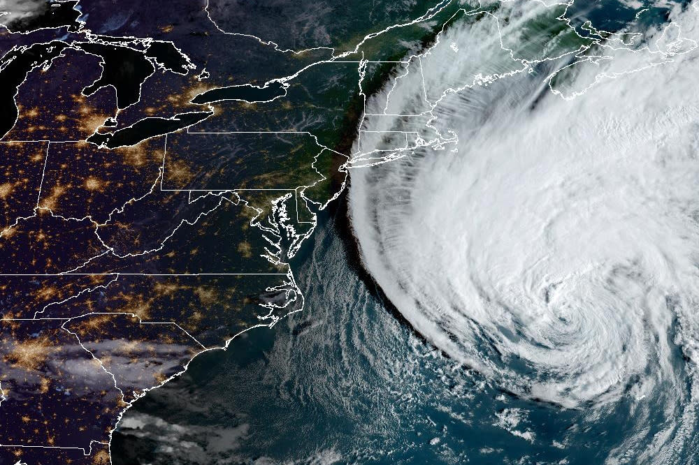
Tracking Hurricane Lee: Storm expected to be ‘large and dangerous’ as it approaches coastal New England and Canada
Tropical storm conditions and coastal flooding are expected to start in southern New England Friday evening and will extend northward along the New England coast and over parts of Canada through Saturday. These hazardous conditions could lead to downed trees and potential power outages.
Parts of New Brunswick and much of Nova Scotia are expected to see hurricane conditions on Saturday for areas within the hurricane watch area.
Timing: Lee, a Category 1 storm with maximum sustained winds of 80 mph, is moving north at 20 mph. On Friday evening the center of the storm was forecast to move farther away from Bermuda and approach coastal New England and Canada.
Read more on Yahoo News: How the wide wind field of Hurricane Lee will cause problems beyond its direct path, from Accuweather
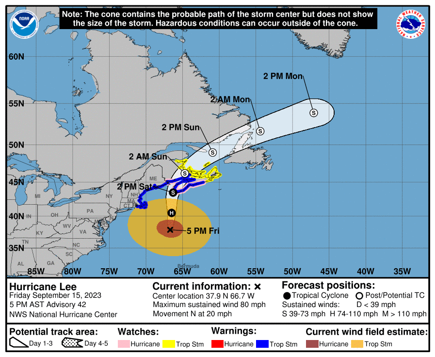
Hurricane watches in effect:
New Brunswick from the U.S./Canada border to Point Lepreau, including Grand Manan Island
Nova Scotia from Digby to Ecum Secum
This means that hurricane conditions are possible within the watch area. Watches are typically issued 48 hours before the first expected occurrence of tropical storm-force winds.
Tropical storm warnings in effect:
Westport, Mass., northward to the U.S./Canada border
Martha’s Vineyard
Nantucket
New Brunswick from the U.S./Canada border to Fort Lawrence, including Grand Manan Island
New Brunswick from Shediac to Tidnish
Nova Scotia from Fort Lawrence to Point Tupper
This means that tropical storm conditions are expected somewhere within the warning area within 36 hours.
Tropical storm watches in effect:
Prince Edward Island
Magdalen Islands
New Brunswick from Belledune to Shediac
Nova Scotia from Tidnish to Aulds Cove
Nova Scotia from Aulds Cove to Meat Cove to Point Tupper
This means that tropical storm conditions are expected there within 48 hours.
Storm surge: Forecasters are warning that if peak storm surge happens during high tide, the water could surge between 1–3 feet in the following areas:
East of Montauk Point, N.Y., to U.S./Canada border
Cape Cod
Martha's Vineyard and Nantucket
Boston Harbor
Rockaway Inlet, N.Y. to Montauk Point, N.Y.
Long Island Sound
Read more on Yahoo News: Flights canceled, cruises changed ahead of Hurricane Lee, from CBS News
Lee’s strength and impact: Lee is expected to remain large and dangerous when it reaches coastal New England and Canada. As of Friday evening, hurricane-force winds extended out 115 miles from Lee’s center, while tropical-storm-force winds extended out to 345 miles.
What kind of damage could a Category 1 storm cause? While the lowest ranking on the hurricane scale, category 1 storms pack winds measuring between 74 mph and 95 mph, strong enough to cause substantial damage to trees and property. According to the National Weather Service: “Well-constructed frame homes could have damage to roof, shingles, vinyl siding and gutters. Large branches of trees will snap and shallowly rooted trees may be toppled. Extensive damage to power lines and poles likely will result in power outages that could last a few to several days.”
