Storm surveys find EF2 tornado damage in Alabama


More than two dozen tornadoes touched down amid a severe weather outbreak that unfolded across a large part of the southern United States from Tuesday through Thursday, capping a week of severe weather worries that included a rare high-risk outlook.
The National Weather Service Storm Prediction Center (SPC) isn't quick to issue a high-risk severe weather outlook, the highest level in a five-tier alert system, as the prediction is reserved for days when there is high confidence in a particularly dangerous severe weather setup.
Wednesday marked the first day the SPC delivered the daunting threat level since May 2019, and the first time in March since 2012. Thanks to days of preparation and some fortunate weather conditions that AccuWeather forecasters credit with limiting the intensity and overall number of tornadoes, injury totals were kept to a minimum and no fatalities were reported on both Wednesday and Thursday.
While millions of Americans dealt with the threatening weather on Wednesday, only two injuries were reported, and both were reported in Clarke County, Alabama. Farther north, preliminary storm survey findings from the NWS Birmingham office indicated EF-2 tornado damage was dealt to parts of Chilton County. That twister had peak winds of 130 mph.
 |
An EF-2 tornado in Chilton County, Alabama, dealt extensive damage to many buildings in the area. (Twitter/@NWSBirmingham) |
Survey findings also revealed EF-1 tornado damage in Moundville, Alabama, from Wednesday, where 110-mph winds dealt heavy damage to many buildings and ripped numerous roofs off.
On Thursday, no injuries were reported despite another 50 severe weather reports.
"THANK YOU Central AL for preparing beforehand & for heeding the warnings yesterday!! We are very thankful & happy to report there were NO fatalities," NWS Birmingham shared on Twitter Thursday night. "However, many people are picking up whatever is left of their belongings. Please keep them in your thoughts & prayers."
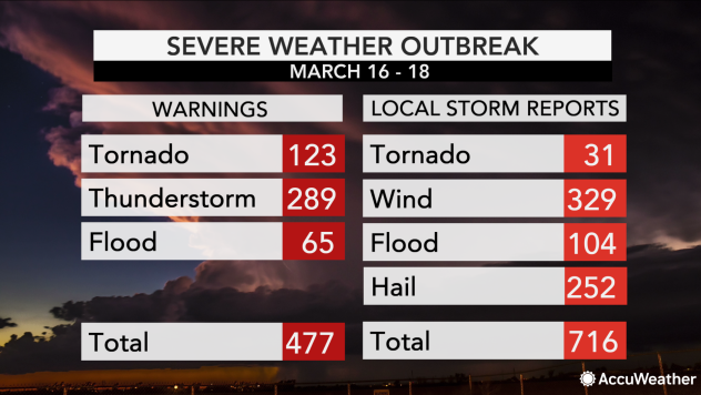
The number of warnings issued as well as storm reports that were counted also tell the story of just how active a stretch it was. In total, there were more than 470 warnings and more than 716 storm reports over the three-day span.
 |
Severe weather outbreak stats from March 16-18, 2020. |
On Thursday, an EF-0 tornado touched down in the southern Georgia town of Bristol in Pierce County at 1:38 p.m. and left tree damage in its wake. By 2:46 p.m., another EF-0 tornado touched down in Florida and moved through portions of Gilchrist County and Alachua County, damaging multiple vehicles and ripping one roof off a building.
Elsewhere in Georgia, the state dealt with flash flooding as well on Thursday, as heavy rain inundated streets in Atlanta and trapped cars in water levels that reached vehicle windows.
As the severe conditions advanced, another EF-0 tornado was reported in Virginia in Isle of Wight County. That event littered roads with tree limbs, downed power lines and inflicted storm damage on Colosse Baptist Church, where pillars of the church were missing and the roof was left damaged, according to WAVY.
The severe weather also left some of its gustiest impacts in central North Carolina on Thursday, as heavy straight-line winds snapped a basketball pole in half and sent a trampoline flying across town in the Cedar Grove neighborhood, according to ABC11. Three tornadoes, two rated EF-1 and one rated EF-0 were also confirmed to have touched down in the state that day according to the NWS.
 |
Wednesday's destruction largely focused on Alabama, where 19 of the day's 27 tornadoes were spotted, according to preliminary reports from the SPC. Three of those were in Clarke County, including the aforementioned tornado that caused two injuries around 4:30 p.m. local time.
According to WPMI, injuries were sustained by a woman and her toddler when their home was destroyed by a tornado that went on to destroy three other homes in the northern portion of the county.
AccuWeather National Reporter Bill Wadell was in Fairview, Alabama, on Wednesday evening to survey tornado damage.
Chilton County Sheriff John Sharon told Wadell that everyone was safe and accounted for after the tornado touched down. "Seeing the amount of damage that you have, I mean homes just totally destroyed, it's a miracle that everybody is OK here," Shearon told Wadell.
In Tuscaloosa, multiple shelters were opened for community members on Wednesday, and University of Alabama students sought shelter in place for hours. Classes were suspended for the day after 11 a.m., and buildings throughout campus were closed as large crowds of students were ushered into seven storm shelters on campus.
The scene in John England until a few minutes ago. Warning in place until 4:15 but people are flooding out. pic.twitter.com/UUtU0XgxTj
— keelykbrewer (@keelykbrewer) March 17, 2021
A pair of tornadoes touched down in the college town, damaging multiple homes and roaring past the John England Jr. Hall on campus, where many students crowded together to take cover.
Heavy rain and strong winds also thrashed the Southern states on Wednesday, as 85 reports of strong wind gusts were reported along with 43 instances of hail. Most of the wind events came from Texas and Mississippi, where a plethora of downed tree limbs fell on power lines leaving many thousands of residents in the dark.
While southern Alabama dealt with the majority of tornado worries, it was the northern portion of the state that had to deal with extensive flooding. In Colbert County, evacuations required first responders to use boats to reach homes, as the Colbert County Emergency Management Agency said floodwaters were as deep as about 5 feet.
 |
As of Thursday evening. |
A large reason the injury total wasn't higher and there were no fatalities was due to favorably cool conditions that diminished the quantity and severity of twisters.
"It is all tied in to limiting daytime heating," AccuWeather Senior Meteorologist Alex Sosnowski explained. "When you have cloud cover, the sun can't get through as much and warm the ground at a quick pace. When the ground is wet, more of the sun's energy goes toward evaporating the moisture from the ground, rather than heating the ground."
In order to thrive and grow, more severe thunderstorms tend to need warm air originating from a heated ground, Sosnowski went on to say.
These warm air updrafts help thunderstorms to form and become more vigorous. Take away the heating, such as most cases during the overnight hours, and storms tend to weaken in all but the most dynamic situations, he said.
Although forecasters credit weather conditions for reducing the intensity and overall number of tornadoes that developed, ingredients still came together for numerous twisters to form -- and reporters and storm chasers were spread across the region to capture nature's ferocity.
Near Silas, Alabama, drone footage captured a tornado triggering multiple power flashes and ripping up trees. In the shocking video from Brian Emfinger of Live Storms Media (LSM), bright blue bolts of electricity from power lines being snapped can be seen lighting up the surrounding foliage as intense winds spew debris high into the air. According to reports from the SPC, a tornado in that area damaged four homes and downed many trees around 4 p.m. local time.
 |
Drone footage shot by Brian Emfinger captured bursts of blue light emanating from electrical power bursts as lines were being snapped during a tornado. (LSM/Brian Emfinger) |
Equally startling drone video was captured in Demopolis, Alabama, showing a massive tornado leaping over the Black Warrior River on Wednesday. Shot by Brandon Clement of LSM, the video also showcases the exact moment the huge twister touches down for a second time on the opposite river bank, giving the appearance of the storm taking a galloping stride.
An ominous funnel cloud in Brookhaven, Mississippi, was spotted by Clancie Daley shortly before 1 p.m. on Wednesday. Daley filmed the cloud looming overhead as lightning bursts flashed around the sky. Officials from the local emergency management agency reported a tornado in the area around that same time as the suspected twister damaged trees and ripped off a roof.
On Friday, the Mississippi Emergency Management Agency reported the NWS has surveyed and confirmed a total of six tornadoes across the state with at least 37 homes and four businesses affected by the storms. About 15 counties and a group of the Choctaw Nation in the state have submitted damage reports to the agency. These numbers are preliminary and may change.
 |
Drone footage from Brandon Clement captures the moment a tornado leaps over the Black Warrior River in Demopolis, Alabama, and makes landfall on the opposite bank. (LSM / Brandon Clement) |
Outside of Alabama, tornadoes were also reported in Arkansas, Missouri, Louisiana and Mississippi. The twisters downed trees in Missouri and damaged multiple buildings in Mississippi on Wednesday. The damage in Mississippi occurred in Wayne County, where an afternoon twister damaged two homes and destroyed three chicken houses, according to WLBT.
On Twitter, Alabama Gov. Kay Ivey thanked the meteorologists, first responders and emergency managers for their quick actions and preparation.
"After an exhausting day & night of intense weather, the storm system has finally moved out of AL," Ivey posted on Twitter Thursday morning. She later added, "Overall, we have a lot to be grateful for as it could have been much worse. I'm praying for all those that have been severely impacted & stand ready to assist in the recovery efforts."
Keep checking back on AccuWeather.com and stay tuned to the AccuWeather Network on DirecTV, Frontier, Spectrum, FuboTV, Philo, and Verizon Fios.
