Will South Florida catch a break after tornado rips through parts of Palm Beach County?
There was a full Sunday sermon of weather warnings for South Florida, but forecasters say that the work week will be an entirely different story.
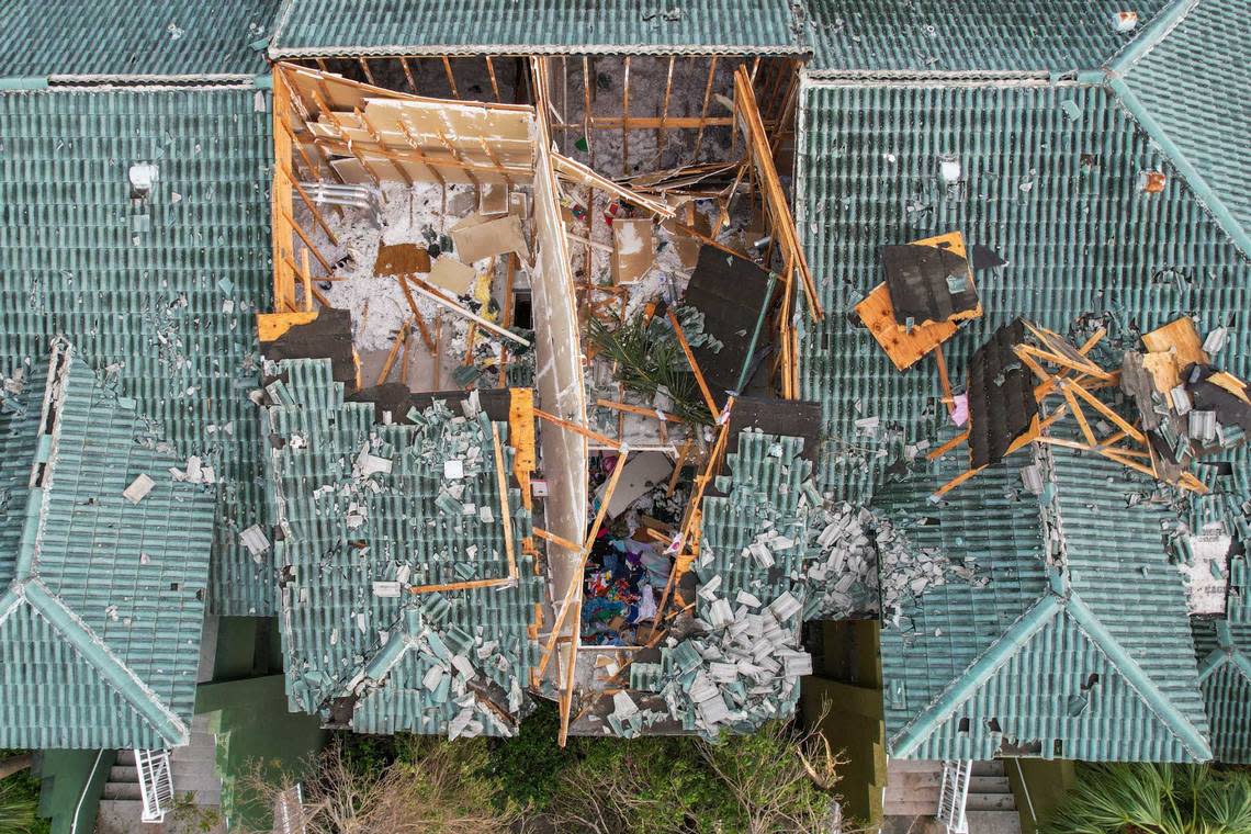
A tornado with wind speeds of around 130 mph overturned cars, ripped roofs, snapped trees and took down power poles Saturday afternoon in parts of Palm Beach County. The destructive vortex with violently rotating winds caused havoc in the city of Palm Beach Gardens, prompting authorities to shut down key roadways as workers removed debris and examined the wreckage. Despite the extensive damage caused by the tornado nearly a month before the start of the Atlantic hurricane season, no deaths or injuries had been reported as of Sunday.
The EF-2 tornado — a category reserved for tornadoes with 111-135 mph winds — started at 5:10 p.m. east of Interstate 95, just south of the Palm Beach Gardens Medical Center, the National Weather Service in Miami said Sunday afternoon. It then tracked northeast for more than two and a half miles, passing where PGA Boulevard and U.S. 1. meet, and dissipated at 5:21 p.m. before reaching Juno Beach. On Saturday, the weather service had preliminarily categorized the tornado as a weaker EF-1.
READ MORE: See photos, videos of tornado flipping cars and destroying homes in Palm Beach County
Most of the Florida Peninsula — including Miami and Fort Lauderdale — was under a tornado watch Sunday afternoon until around 12:30 p.m. but no additional tornadoes were reported. A wind advisory was set to expire Sunday night while the risk of rip currents will be high Monday and Tuesday in parts of South Florida.
NWS Miami can confirm an EF-2 tornado occurred yesterday April 29, 2023 in Palm Beach Gardens. Multiple reports of damage to trees, homes, buildings, power poles and cars. For more information visit the latest Public information Statement: https://t.co/Y5tBQ8SZWz pic.twitter.com/i94is2rnFL
— NWS Miami (@NWSMiami) April 30, 2023
Will the bad weather carry on? Here’s what the forecast says.
Will the severe weather threat continue?
The cold front that was impacting the Florida Peninsula shifted offshore and the severe weather threat has ended, the National Weather Service in Miami tweeted Sunday afternoon.
“For even better news, rain chances will remain about 0 through mid-week, giving South Florida a well-deserved break!” the weather service said.
Good news!
The front has shifted offshore, and the severe weather threat has ended. Clouds will begin to clear from W-E this afternoon as drier air filters in.
For even better news, rain chances will remain about 0 through mid-week, giving SFL a well-deserved break!#FLwx pic.twitter.com/xwcH3d74CJ— NWS Miami (@NWSMiami) April 30, 2023
With the threat ending, much drier air approached South Florida, tweeted NBC 6 meteorologist Ryan Phillips
“We have a few beautiful days ahead, too!” he wrote.
With the severe weather threat ending, sharply drier air will sweep into area for the remainder of the day.
A sunset stroll should feel a lot less humid vs. an afternoon walk.
We have a few beautiful days ahead, too! pic.twitter.com/xyhZCv4IyJ— Ryan Phillips - NBC6 (@RyanNBC6) April 30, 2023
What’s South Florida’s forecast?
Miami-Dade, Broward and Palm Beach counties are expecting a sunny Monday with temperature highs in the mid 80s and lows in the 60s, according to the weather service.
Temperatures are forecast to slightly increase Tuesday with highs in the upper 80s followed by a cloudy night with lows in the 60s.
On Wednesday, temperatures could increase even further in some areas — including in Miami and Fort Lauderdale — with highs from the mid 80s to the low 90s followed by lows in the mid to upper 60s.
By Thursday and Friday, forecast will be mostly clear with highs in the mid to upper 80s and lows between the upper 60s and around 70 degrees.
READ MORE: U.S. Coast Guard crew saves three men from sunken boat off Dry Tortugas National Park
Is it safe to go to the beach?
South Floridians know that a sunny day does not always equal to a safe day at the beach.
On Monday and Tuesday, there will be a high risk of rip currents in the coasts of Palm Beach County. This means that there is a significant risk of life threatening rip currents and swimming is not recommended.
The risk of rip currents will be low to moderate in Broward and Miami-Dade counties during the same time period but rip currents may still occur.
Expect a calmer coastline Wednesday and Thursday in Miami-Dade and Broward counties with a low risk of rip currents while Palm Beach County experiences a moderate risk.
