Tallahassee area on tornado watch: Forecasters warn of flooding, hail, gusts up to 75 mph
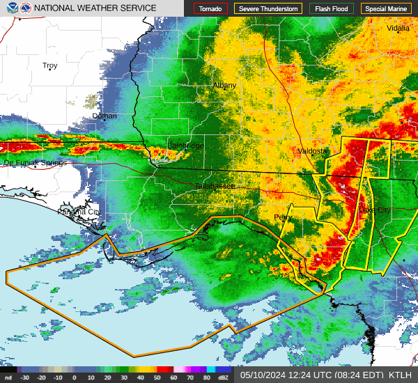
➤ Track storms with live radar
A potent storm system could bring dangerous winds, large hail and flash flooding to the area overnight and into Thursday morning.
Parts of Alabama, Georgia and Florida, including Tallahassee, are under a tornado watch until 9 p.m. Wednesday. A wind advisory and flood watch has also been issued until Thursday at 2 p.m.
Already the system has been associated with 70 mph wind gusts, a few tornadoes across Louisiana and a "flash flood emergency" in New Orleans.
"This one definitely is one of the stronger ones we've seen this year," said National Weather Service - Tallahassee meteorologist Joe Worster of the storm system. "There are some pretty potent dynamics."
Some portion of the region is likely to get very heavy rain and possible flash flooding. If you encounter flooding, remember, turn around don't drown. #FLwx#ALwx#GAwxpic.twitter.com/CuJhVeMcfO
— NWS Tallahassee (@NWSTallahassee) April 10, 2024
Forecasters warn that the system could spawn a "couple strong tornadoes" and generate an isolated barrage of "ping-pong ball sized hail." They say the region could see scattered gusts of up to 75 mph winds.
"Severe storms are pushing east ... and will be knocking on our door within the next couple hours," forecasters wrote on X. "There’s a history of strong winds, rotation, and heavy rain with this activity."
Forecasters expect the brunt of the bad weather to hit the Tallahassee area overnight between 3 a.m. and 8 a.m. Thursday.
"Have multiple different ways to receive warnings," Worster said. "Make sure your phone volume is turned up and have a place to go in most interior room of your house or anywhere with no windows."
Ahead of the storms' arrival, Jefferson County Schools District announced it made the decision to close its schools Thursday "with the safety and well-being of our students and staff in mind." Wakulla County later followed suit and closed its schools on Thursday. Leon County Schools opted to delay its school day by an hour.
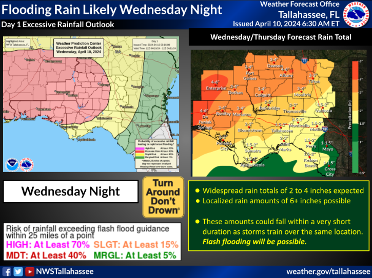
The Tallahassee area could be pelted with up to 2 inches of rain with points further west like Marianna seeing up to 4 inches of rain.
"This system could certainly overperform," Worster warned.
A tornado watch has been issued for parts of Alabama, Florida and Georgia until 9 PM EDT pic.twitter.com/CvKgJJjlSZ
— NWS Tallahassee (@NWSTallahassee) April 10, 2024
Flood watch issued until Thursday
A flood watch is in effect from Wednesday evening through Thursday afternoon. Excessive rainfall, likely to produce flash and river flooding.
EARLIER STORY
A warm front is expected to move into Florida's Panhandle Wednesday afternoon and evening, followed by a strong cold front, according to the Florida Division of Emergency Management.
Expect scattered showers and thunderstorms in the afternoon and widespread showers and thunderstorms this evening and overnight.
The Storm Prediction Center is predicting an enhanced risk for severe weather — 3 out of 5 — especially wet of the U.S. 231 corridor. A slight risk for severe weather — 2 out of 5 — extends into Tallahassee.
The strong to severe thunderstorms could bring multiple hazards, including tornadoes, damaging wind gusts and hail.
There's a possibility some tornadoes in the western Panhandle could be strong, EF-2 or greater, the Division of Emergency Management said. An EF-2 tornado has wind speeds of 111-135 mph.
Damaging wind gusts of 50 to 70 mph within severe thunderstorms are also a threat, along with the potential for hail from dime to quarter size.
The threat for severe thunderstorms will primarily be overnight Wednesday and into early Thursday morning.
Weather watches and warnings issued across the U.S.
Weather alerts issued in Florida
Power outages for Tallahassee
Weather radar and forecast for Pensacola

Follow National Weather Service Mobile on X, formerly known as Twitter
Weather radar and forecast for Tallahassee
Follow the National Weather Service Tallahassee on X, formerly known as Twitter
This article originally appeared on Treasure Coast Newspapers: Flooding, tornado watch forecast for North Florida, Tallahassee
