I can’t get to my home on Pine Island. But I can see the damage from Ian. Here’s how
If you live in one of the hurricane-ravaged areas of Southwest Florida like I do, and haven’t been able to get to your property to survey the damage because of high water, washed-out roads or gaps in bridges, there is help.
The National Oceanic and Atmospheric Administration’s National Geodetic Survey, whose mission is to survey the coastline and create nautical charts, is providing satellite images of hard-hit Southwest Florida coastal areas after Hurricane Ian swept through.
Go to ngs.noaa.gov, click on storm images and then click on Hurricane Ian (2022) to view an area that stretches from Marco Island on the south to Venice in the north. The images include views of storm-damaged areas in the Naples area, Fort Myers, Fort Myers Beach, Punta Gorda, Port Charlotte, and the barrier islands.
To view the NOAA images, click here
The island images for Sanibel, Captiva, and Pine Island to the north are especially interesting because these islands remain largely inaccessible to vehicles due to bridge and road damage.
Zero in on your home
Once you arrive at the website, zero in on your neighborhood and keep enlarging until you find your home, business or lot. Although the images start to blur the more you enlarge them, you will be able to see if your house or business is still standing, whether it still has a roof and other details.
At my house on Pine Island, for example, I can see that part of the garage roof is missing, the roof of the shed has been peeled back, the gazebo is missing, the kayak dock has slammed into the boatlift and something has fallen on the orange truck in the driveway.
What you won’t be able to determine from the satellite pictures is whether water or wind got inside your property. I’ve been told my back lanai, which is nearest the canal, is swimming in mud, but you won’t be able to see that degree of detail.
In St. James City on the southern tip of Pine Island, you can see debris fields where structures have been swept away, submerged boats in the canals, and boats broken free of their moorings sitting sideways in canals. The satellite images will allow you to see if your boat is still on its lift or anchored at your dock
Damage to roofs appears as brown areas or in some cases you can see bare rafters. For the most part, it looks like metal roofs stood up to the storm.
READ MORE: Recovery plans using ferry, barges start to take shape for isolated Pine Island
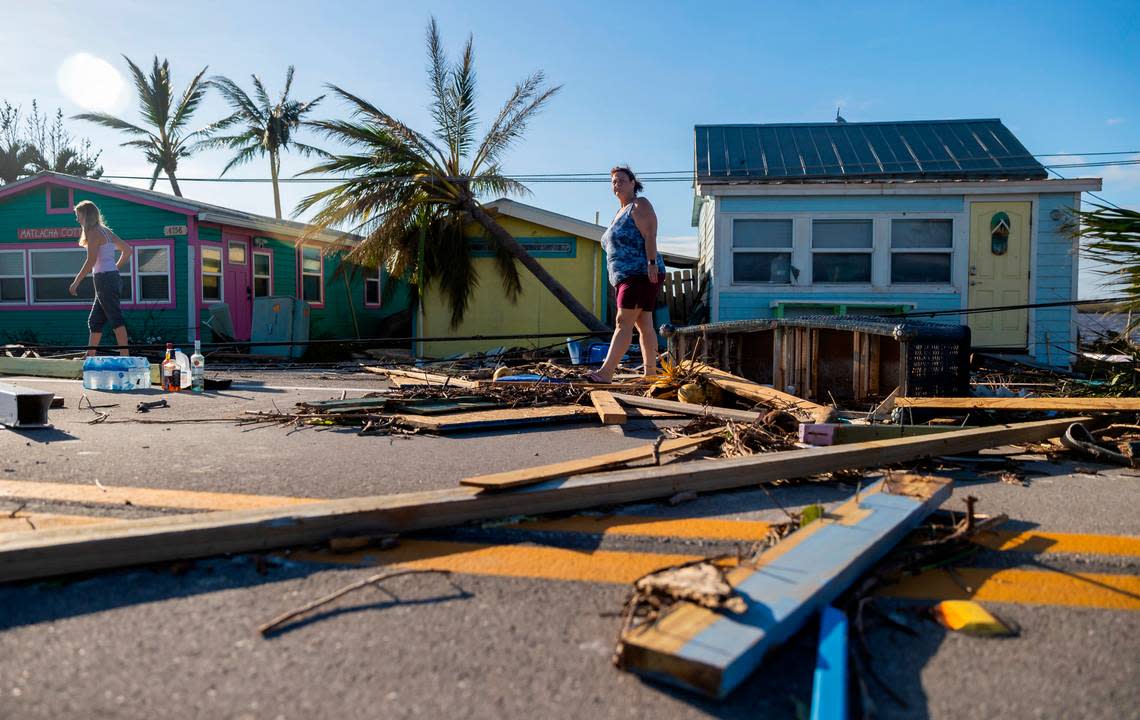
See the damage to Matlacha
In Matlacha, an eclectic enclave of colorful cottages, art galleries, fish houses, restaurants, and shops on the road to Pine Island, you can see the washed-out road before the draw bridge, empty spaces where some buildings were destroyed and a huge debris field.
READ MORE: Ian leaves destruction, and death, in Matlacha. Colorful village flattened, isolated
The National Geodetic Survey was established in 1807 by President Thomas Jefferson as the Survey of the Coast. Its mission was the same as it is now: to survey the coast to ensure safer maritime activity.
The first geodetic satellite was launched in 1962. Geodesy is the science that measures and determines positions of points on the earth’s surface to understand the planet’s geometric shape, position in space and gravity.
During a 1970 reorganization, the geodetic survey became part of NOAA.
Mimi Whitefield, a former foreign correspondent for the Miami Herald, lives on Pine Island. She evacuated before the storm hit. Reach her at miamimimiw@gmail.com
