Typhoon Mawar slams Guam with ferocious winds

Powerful Typhoon Mawar barreled over Guam on Wednesday with fierce winds and a devastating storm surge. AccuWeather meteorologists say the cyclone was likely the strongest in decades to impact the islands as it unleashed life-threatening flooding and damaging winds into midweek.
A typhoon warning remained in effect late Wednesday local time for Guam and the island of Rota as Mawar passed by, unleashing destructive winds in the process.
Mawar is just about 15 miles to the northwest of Guam and 40 miles to the southwest of Rota. The storm will remain on a north-northwest track through Wednesday, local time, with some additional strengthening possible. Mawar is projected to reach Category 5 strength on the Saffir-Simpson Hurricane Wind Scale after passing the island over the open Pacific.
The typhoon roared through Guam and the Mariana Islands early Wednesday (Eastern Time) as a Category 3 storm, according to AccuWeather meteorologists.
"The north-northwest track is expected to continue over the next day or two with additional strengthening likely," explained AccuWeather Lead International Forecaster Jason Nicholls.
The Federal Emergency Management Agency (FEMA) announced Tuesday that President Joe Biden approved federal disaster assistance for the territory of Guam to "supplement territorial and local response efforts due to emergency conditions resulting from Typhoon Mawar."
"The President's action authorizes FEMA to coordinate all federal disaster relief efforts to alleviate the hardship and suffering caused by the emergency on the local population and to provide appropriate assistance to save lives, to protect property, public health and safety and to lessen or avert the threat of a catastrophe territory wide," FEMA officials said in a press release.
Rainfall will increase in intensity with strengthening winds as Mawar continues to impact Guam with the worst conditions expected to last into Wednesday evening, local time. Heavy rain will continue in Guam and the Mariana Islands through Wednesday night, local time, with rainfall amounts of 8-15 inches (200-380 mm) expected with the AccuWeather Local StormMax™ of 24 inches (610 mm). Rainfall of this magnitude can result in flash flooding and mudslides, blocking roads and delaying travel.
The strengthening storm is expected to produce wind gusts to 180 mph (290 km/h) with the AccuWeather Local StormMax™ of 200 mph (320 km/h) across portions of Guam and the Northern Marina Islands Wednesday, local time, which can result in damage and power outages. Rough surf and coastal flooding are also expected across the archipelago.
Because of the wind and rain, Mawar is a 4 on AccuWeather's RealImpact™ Scale for Tropical Cyclones. The six-point scale ranges from "less than one" and 1 to 5, considering several factors such as rainfall, wind speed and potential damage.
 |
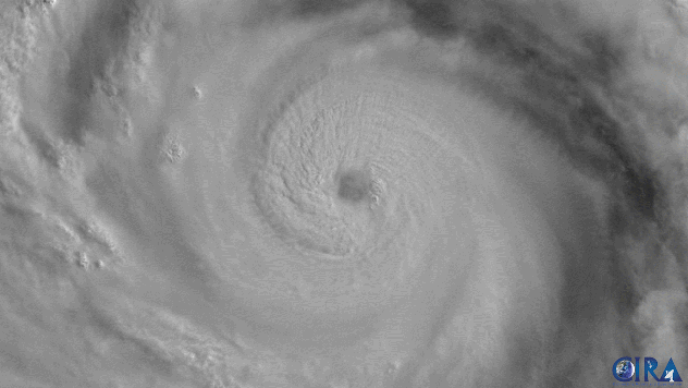
Visible satellite loop of Mawar on Tuesday morning local time. |
Typhoons have impacted Guam and the Mariana Islands many times in the past. Since 2000, a total of 23 typhoons have tracked within 200 miles of Guam.
In 2002, in particular, Typhoon Pongsona caused extensive damage to Guam, destroying 1,300 homes and resulting in $1 billion in damage (2023 USD). Pongsona passed to the east of the island with wind speeds of 150 mph -- equivalent to a Category 4 storm. Typhoon Pongsona is the strongest storm to pass within 50 miles of the island since 2002.
In more recent years, Guam was also impacted by Typhoon Mangkhut in 2018 and Typhoon Wutip in 2019, which resulted in $4.3 million and $1.3 million in damage, respectively.
 |
Beyond the middle of the week, Mawar may take a more west-northwest track and approach Taiwan or the southern Ryukyu Islands of Japan early next week. An eventual turn to the northeast is expected early next week, but there are some model differences on the timing of this turn.
There is a chance for rain and wind over the southern Ryukyu Islands early next week, but if the turn to the northeast is slower then rain could reach as far west as Taiwan. Impacts on southern Japan cannot be ruled out late next week, depending on the exact track of the storm.
Want next-level safety, ad-free? Unlock advanced, hyperlocal severe weather alerts when you subscribe to Premium+ on the AccuWeather app. AccuWeather Alerts™ are prompted by our expert meteorologists who monitor and analyze dangerous weather risks 24/7 to keep you and your family safer.
