Strong storms, tornadoes possible in Midlands. Here’s when severe weather is forecast
Powerful and dangerous storms are moving across the Southeast and are forecast to affect the Columbia area on Friday.
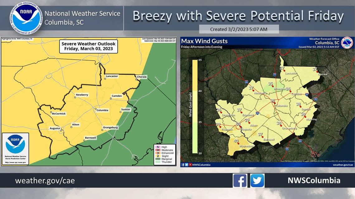
Showers and strong storms are expected to develop ahead of a cold front that will move through the Midlands on Friday night, according to the National Weather Service. The storms could produce damaging wind gusts and include the risk of tornadoes, the National Weather Service said.
It remains uncertain as to exactly when the strongest storms might hit the area, but breezy and powerful winds are forecast to begin early Friday, according to the National Weather Service. Those winds could produce gusts between 35 to 40 mph, according to a hazardous weather outlook.
The current forecast shows that the winds will weaken after midnight in Richland and Lexington counties.
Any tornadoes would be most likely to form in the northwest portion of the Midlands, the National Weather Service said.
Across the Midlands, powerful winds and tornadoes could cause considerable damage to trees and branches, in addition to mobile homes, roofs and outbuildings. Vehicles would also be under siege in the case of a tornado.
Damage to trees and branches creates the possibility of downed power lines and outages.
No warnings or watches have been issued, but that is subject to change as the storms get closer. A lake wind advisory will go into effect at noon Friday and run through 7 a.m. Saturday, according to the National Weather Service.
“Boaters should use extra caution on lakes because the rough waves can cause small crafts to overturn,” the National Weather Service said.
Rain is expected later in the day Friday, and most likely at night, the National Weather Service said.
Less than half an inch of rain is expected in the Columbia area on Friday, the forecast shows. Localized amounts in other areas of the Midlands could be higher.
Once the storms move through the area, the forecast for the rest of the weekend and into Monday calls for clear, sunny conditions with high temperatures in the 70s, according to the forecast.
More rain is possible next Wednesday, the forecast shows.
March 1 was the first day of meteorological spring, which means the severe weather season is beginning, according to the National Weather Service.
There have already been powerful storms that affected the Midlands in 2023.
In the first week of January, five tornadoes were confirmed in the Midlands.
During those Jan. 4 storms, wind bursts as powerful as 90 mph were recorded as tornadoes were confirmed in Lexington, Orangeburg, Aiken and Calhoun counties, the National Weather Service said.
A week later, another tornado was confirmed just across the state line in Georgia, before the storms marched through the Midlands, according to the National Weather Service.
Another round of storms rumbled through the region in the last week of January. Severe weather wasn’t as much of a threat in February, but record-high temperatures were recorded across the Midlands.
