Storms bring threat of tornadoes, grapefruit-sized hail to 33 counties, Lubbock included
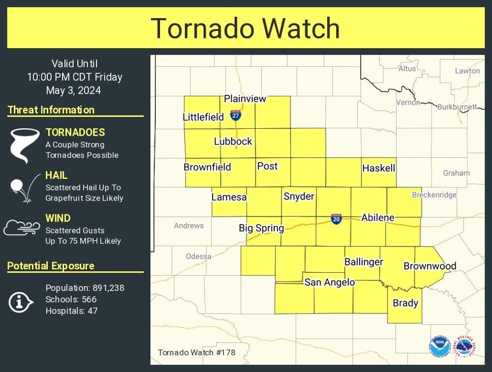
Much of the South Plains, including Lubbock County, and the Big Country are under a tornado watch until 10 p.m. Friday, with a line of severe storms already developing and moving east across West Texas.
Lubbock is one of 33 Texas counties under the watch could see severe weather today, including tornadoes and grapefruit-sized hail. As the storms roll in, here's what we know:
UPDATED 5:40 p.m. A severe thunderstorm warning was issued until 6:15 p.m. for northwestern Garza County and Crosby County.
At 5:30 p.m., a severe thunderstorm was located five miles south of Caprock, or 12 miles east of Slaton, moving north at 35 mph. The storm had the potential for 60 mph wind gusts and half-dollar-size hail.
UPDATED 5:35 p.m.
A tornado warning for portions of Hale County near Plainview and a severe thunderstorm warning for Briscoe, Floyd, Hale and Swisher counties was cancelled at 5:24 p.m. as the storm weakened below severe limits and no longer poses an immediate threat to life and property.
The storms are part of a line moving east from the South Plains into the Rolling Plains and Big Country Friday evening.
UPDATED 4:50 p.m.: A tornado was confirmed between Hale County and Plainview after 4:30 p.m. Friday - part of a line of severe thunderstorms moving through the South Plains Friday afternoon. A tornado warning was issued for Hale County, including Plainview and Hale Center, until 5 p.m.
At 4:35 p.m., a tornado confirmed by weather spotters was located four miles north of Hale Center, moving east at 25 mph, according to the National Weather Service. The tornado was expected to approach Plainview.
"Flying debris will be dangerous to those caught without shelter," reads a statement from the weather service. "Mobile homes will be damaged or destroyed. Damage to roofs, windows, and vehicles will occur. Tree damage is likely."
Related: 373 tornadoes hit the US in April — nearly double the average. Here's how many hit Texas
Live updates on May 3 storm in Lubbock, surrounding area:
2:26 p.m.: Tornado Watch issued for multiple counties between 3-10 p.m.
2:11 p.m.: NWS Lubbock reported that strong to severe storms were expected to develop within the next two hours.
What will the weather be like in Lubbock this weekend? Rainy.
The National Weather Service reported more rain is possible this weekend. The forecast, as of 3:11 p.m. Friday, includes:
Saturday: The high temperature will be near 72, with south-southwest wind around 10-15 mph shifting to north-northeast in the morning. The chance for precipitation is 70%, with rainfall amounts between a tenth and a quarter of an inch, though higher amounts are possible during thunderstorms. The low will be around 57, and the night's precipitation chances will increase to 80%. Showers and potentially severe thunderstorms are likely to occur after 4 p.m., and could continue through 4 a.m. Sunday.
Sunday: The high will be around 77 degrees and the low will be around 63. Showers and thunderstorms are likely to happen before 7 a.m., and precipitation chances are 60%. Precipitation chances will lessen to 20% for the night, with showers and storms happening after 1 a.m.
This article originally appeared on Lubbock Avalanche-Journal: Live updates as storms bring tornado, hail threat to West Texas
