New storms to bring more hail, tornado threat, to Dallas-Fort Worth region. Here’s when
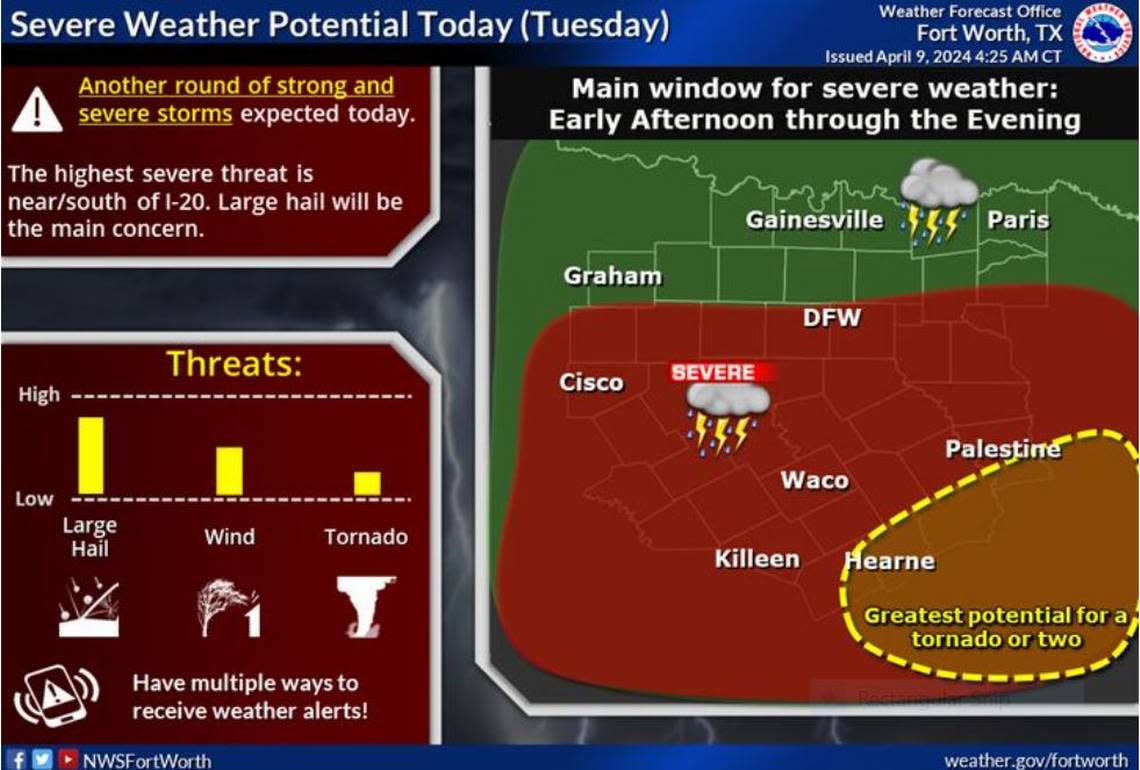
Expect another string of storms to hit Dallas-Fort Worth later today bringing large hail and damaging winds — possibly even tornadoes — to the area, according to a National Weather Service Fort Worth office report early Tuesday morning.
Cyclonic air high in the atmosphere — or an upper level low — is slowly headed for North Texas and will surely suck the warm unstable air roiling in our area upward to spawn thunderstorms and heavy rain across an already soaked region. Some areas may see up to 4 inches of rain south of I-20 and east of I-35.
““Some of this activity is expected to be severe mainly south of I-20/30 corridors with large hail as the primary threat,” Fort Worth meteorologist Patricia Sanchez wrote on the NWS website. “There is still a threat for damaging winds and tornadoes, especially across the far southern zones where both wind profiles and thermodynamics may support it.”
⚡ More trending stories:
→ There’s no ‘better place’ to see April 8 total solar eclipse than in this tiny Texas town.
→In Texas, set your thermostat at 80 when it's 100 degrees, expert says.
→Groceries at this national chain are the cheapest, study finds.
This line of storms will finally move east by Tuesday evening and into Wednesday, Sanchez wrote.
Be aware that this storm can arrive as early as later this morning, and it will linger through most of the day, increasing the threat for flooding across the region, according to the NWS.
“Additional rounds of heavy rainfall will continue flooding concerns today through Wednesday morning,” the NWS forecast states. “A Flood Watch remains in effect for portions of East/Southeast Texas through 7 a.m. Wednesday.”
Much of Texas dodged curse of cloud cover during eclipse
The weather service alerted the region of impending storms they said could arrive mere hours after totality of the solar eclipse Monday. Fears of what the inclement weather could do even forced an eclipse festival in Burnet to shut down hours before the celestial show could unfold.
The turn in the weather did not arrive in time to ruin stargazers’ plans of watching the rare heavenly event. Many Texas towns on the enviable spine of totality, including Hillsboro, hosted thousands of global tourists as they ooohed and aaahed as the moon slowly eased across the face of a sun that in some places was obscured by fleeting clouds.
