Hurricane Lee now ‘extremely dangerous’ Category 5 storm as it churns towards Caribbean: Live
Hurricane Lee rapidly intensified to a Category 5 storm on Thursday night as it churned towards Caribbean islands with “life-threatening” conditions expected to develop in the coming days.
The National Hurricane Center said in its 11pm advisory that the storm could go through “further strengthening” overnight, which could make it one of the rarest hurricanes in the Atlantic.
Lee was located about 705 miles (1,135km) east of the northern Leeward Islands and packing maximum sustained winds of 160mph (260kph).
Forecasters say Lee could become a “monster 180 mph” storm by Friday morning.
The storm is expected to pass well to the north of the northern Leeward Islands, the Virgin Islands, and Puerto Rico over the weekend and into early next week, the forecaster said.
The NHC has warned that dangerous beach conditions were expected to develop around the Western Atlantic through early next week.
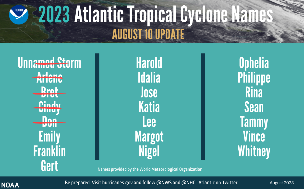
Lee is the 12th named storm of the Atlantic hurricane season, which runs from 1 June 1 to 30 November.
Key Points
Hurricane Lee rapidly intensifies to ‘extremely dangerous’ Category 5 storm
Hurricane Lee could intensify more and become a 'monster' storm
Path of Tropical storm Lee: Where is the storm currently and where will it head?
Hurricane Lee spaghetti models show path storm could take
Will Tropical storm Lee make landfall in the Caribbean or the US?
‘Above normal’
10:15 , Stuti Mishra
The National Ocean and Atmospheric Administration warned in August that this year’s season would produce an above-normal number of storms. Between 14 to 21 named storms are forecast. Of those, six to 11 could become hurricanes, with two to five of them possibly becoming major hurricanes, the agency said.
Meanwhile, AccuWeather updated its forecast, predicting there would be three to five hurricanes Category 3 or stronger this season, compared with one to three in its previous analysis.
AP
How strong will Hurricane Lee become?
09:30 , Stuti Mishra
Hurricane Lee is expected to continue intensifying into Friday and it could attain wind speeds of 180mph or more in the next 12 hours, making it one of the strongest storms in the Atlantic.
Hotter ocean waters this year are contributing to rapid intensification of storms this year, experts have said. Water temperatures in this part of the Atlantic Ocean were record warm in August driven by man-made climate crisis.
Hurricane Jova continues to churn in Pacific as Category 4 storm
08:45 , Stuti Mishra
In the Pacific, Hurricane Jova churned through open waters far from Mexico's southwest coast as a Category 4 storm. It posed no threat to land.
It was located about 600miles (965km) southwest of the southern tip of Baja, California, and was moving west-northwest at 17mph (28kph) with winds up to 145mph (230kph). The storm was expected to start to weaken starting late on Thursday or early Friday.
Lightning strikes can be seen around Hurricane Jova's eye as it achieved category 5 status for a brief time last night. pic.twitter.com/vIKM6jDpgl
— CIRA (@CIRA_CSU) September 7, 2023
Another tropical storm, Margot, forms in the Atlantic
08:03 , Stuti Mishra
While all eyes are on rapidly intensifying Hurricane Lee, another tropical storm has formed in the Atlantic, the National Hurricane Center reported.
Tropical Storm Margot is expected to become a hurricane over the weekend, the NHC said,
The storm was spotted about 355 miles west of The Cabo Verde Islands with maximum sustained winds of 40 mph. It was moving west-northwest at 16 mph.
Tropical Storm #Margot Advisory 3: Margot Moving West-Northwestward Across the Tropical Eastern Atlantic. https://t.co/tW4KeGe9uJ
— National Hurricane Center (@NHC_Atlantic) September 8, 2023
How rare is Category 5 tropical storm?
07:30 , Stuti Mishra
Hurricane Lee is currently packing sustained winds of 160mph, making it a Category 5 tropical storm, which is set to intensify further to 180mph.
Lee is the first storm since Hurricane Ian last year to attain the Category 5 status and only 38 other Atlantic hurricanes have reached Category 5 intensity over the past 100 years.
Here's how quickly Hurricane Lee intensified
07:00 , Stuti Mishra
Hurricane Lee is being termed "one of the fastest" if not the fastest-developing storm ever recorded in the Atlantic, as it went from Category 1 on Thursday morning to Category 5 by the day's end.
The storm is expected to intensify further to reach wind speeds of 180mph by Friday morning.
Here's how Lee's rapid intensification played out:
Lee was a Category 1 storm with 80 mph winds at 5am ET on Thursday. Within 12 hours, its maximum sustained winds had increased to 130 mph, making it a Category 4 storm on the Saffir-Simpson intensity scale.
By 11pm ET, the storm's maximum sustained winds were 160 mph, making it now a Category 5 hurricane.
The storm's maximum sustained winds increased by just over 80 mph in 24 hours, according to the NHC. The escalation greatly exceeds the 35 mph increase needed to fit the definition of rapid intensification.
Watch: 12-hour time-lapse from sky shows how Hurricane Lee intensified from Category 1 to Category 4
06:30 , Stuti Mishra
Hurricane Lee has gone through a rapid intensification in the Atlantic’s warm waters over the day on Thursday and is now a Category 5 storm with fears that it could grow even stronger.
This time-lapse from Cooperative Institute for Research in Atmosphere (CIRA) shows the 12 hour process, from sunrise to sunset, of Lee becoming Category 4 from Category 1.
Over the course of a 12-hour time-span, Hurricane Lee rapidly-intensified from a category 1 to a category 4 storm.
This sunrise-to-sunset imagery shows Lee's evolution today and the development of its impressive eye. It is expected to become a category 5 in the next day. pic.twitter.com/YPWTPsIfCU— CIRA (@CIRA_CSU) September 7, 2023
Hurricane Lee could intensify more and become a 'monster' storm
06:02 , Stuti Mishra
Lee's rapid strengthening into a Category 5 hurricane on Thursday has made it one of the "fastest intensifying Atlantic hurricanes ever observed", experts said, as the National Hurricane Center warned the storm could intensify further by Friday morning.
"Hurricane #Lee has explosively intensified into a Category 5 storm and is expected to peak as a monster 180mph Cat 5," Colin McCarthy, who tracks tropical storms, wrote on X, formerly known as Twitter.
Hurricane #Lee has explosively intensified into a Category 5 storm and is expected to peak as a monster 180 mph Cat 5.
One of the fastest intensifying Atlantic hurricanes ever observed. pic.twitter.com/38efxc07Bj— Colin McCarthy (@US_Stormwatch) September 8, 2023
Experts have warned that if Lee intensifies further and reaches 180mph speed, it would only be the ninth storm in the Atlantic to reach that level.
"If that happens, it would put Lee in an elite club, with 8 other storms reaching 180mph. 5 Atlantic hurricanes on record have had stronger winds," meteorologist Jeff Berardelli wrote.
#HurricaneLee is forecast to peak Friday morning with maximum sustained winds of 180 mph. If that happens, it would put Lee in an elite club, with 8 other storms reaching 180 mph. 5 Atlantic hurricanes on record have had stronger winds. The max: Allen in 1980 had 190 mph winds. pic.twitter.com/gxw1IpNKi0
— Jeff Berardelli (@WeatherProf) September 8, 2023
Hurricane Lee rapidly intensifies to ‘extremely dangerous’ Category 5 storm
05:02 , Stuti Mishra
Hurricane Lee rapidly intensified to a Category 5 storm on Thursday night as it churned towards Caribbean islands with “life-threatening” conditions expected to develop in the coming days.
The National Hurricane Center said in its 11pm advisory that the storm could go through “further strengthening” overnight, which could make it one of the rarest hurricanes in the Atlantic.
Lee was located about 705 miles (1,135km) east of the northern Leeward Islands and packing maximum sustained winds of 160mph (260kph).
Hurricane #Lee Advisory 11: Lee Becomes a Category 5 Hurricane. Dangerous Beach Conditions Expected to Develop Around the Western Atlantic Through Early Next Week. https://t.co/tW4KeGe9uJ
— National Hurricane Center (@NHC_Atlantic) September 8, 2023
What is El Nino and why is it intensifying this year’s hurricanes?
04:00 , Graig Graziosi
The UN’s World Meteorological Organisation (WMO) has announced the return of the weather cycle El Nino, which could lead to record global temperatures this year.
After three years of the cooler La Nina pattern, which often lowers global temperatures slightly, the WMO announced on Tuesday that El Nino conditions were present and are expected to gradually strengthen into the winter.
The last significant El Nino event occurred in 2016, which has gone down as the warmest year the world has seen since records began.
Its recurrence in 2023, when global heating driven by man-made carbon emissions has only accelerated, threatens a “double whammy”, according to the WMO, which has warned there is a 90 per cent probability of it lasting to the year’s end.
That means the likelihood of extreme weather events that could prove life-threatening has also increased, prompting the organisation’s officials to caution world governments that they must be prepared.
READ MORE:

What is El Nino and what impact might it have?
‘Above normal’
03:00 , Graig Graziosi
The National Ocean and Atmospheric Administration warned in August that this year’s season would produce an above-normal number of storms. Between 14 to 21 named storms are forecast. Of those, six to 11 could become hurricanes, with two to five of them possibly becoming major hurricanes, the agency said.
Meanwhile, AccuWeather updated its forecast, predicting there would be three to five hurricanes Category 3 or stronger this season, compared with one to three in its previous analysis.
AP
Watch: Hurricane Lee to keep intensifying in the days to come
02:00 , Graig Graziosi
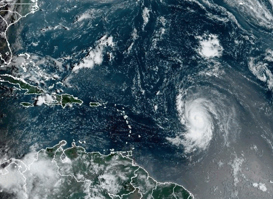
Pictured: Hurricane Lee from space
01:00 , Graig Graziosi
Hurricane Lee was captured by the National Oceanic and Atmospheric Administration (NOAA) satellite on Thursday as it spins towards the Leeward Islands.
Watch: Hurricane Lee expected to be 'extremely dangerous'
Friday 8 September 2023 00:00 , Graig Graziosi
Hurricanes are getting stronger. Here’s why
Thursday 7 September 2023 23:20 , Louise Boyle
As the global average temperature increases, largely due to the carbon emissions from burning fossil fuels, the ocean is taking a major hit.
The ocean has absorbed 90 per cent of warming in recent decades and all that extra heat is driving historically high water temperatures.
Warmer waters supercharge tropical cyclones with more heavy rainfall and storm surge as they come ashore.While the frequency of hurricanes of tropical storms is not increasing, the chance that they become stronger, more destructive systems has increased by about 8 per cent per decade in the past 40 years, according to climate scientists.
The proportion of Category 4 and 5 tropical cyclones is projected to increase around the world in the coming decades due to human-caused warming, according to the latest report from the UN’s Intergovernmental Panel on Climate Change (IPCC).
The Atlantic hurricane season, which runs from 1 June to 30 November, is forecast to be above average this year.
‘Well above normal’
Thursday 7 September 2023 23:00 , Graig Graziosi
Record hot ocean temperatures and a tardy El Nino are doubling the chances of a nasty Atlantic hurricane season this summer and fall, the National Oceanic and Atmospheric Administration said last month.
With the Atlantic hurricane season already well above normal so far, NOAA increased how many storms to expect and how busy the season can get.
The agency says there’s a 60 per cent chance for an above normal hurricane season, twice the agency’s May forecast which said it was 30 per cent.
The earlier forecast leaned more toward a near normal season with a 40%, but the chance for normal has now shrunk to 25 per cent.
AP
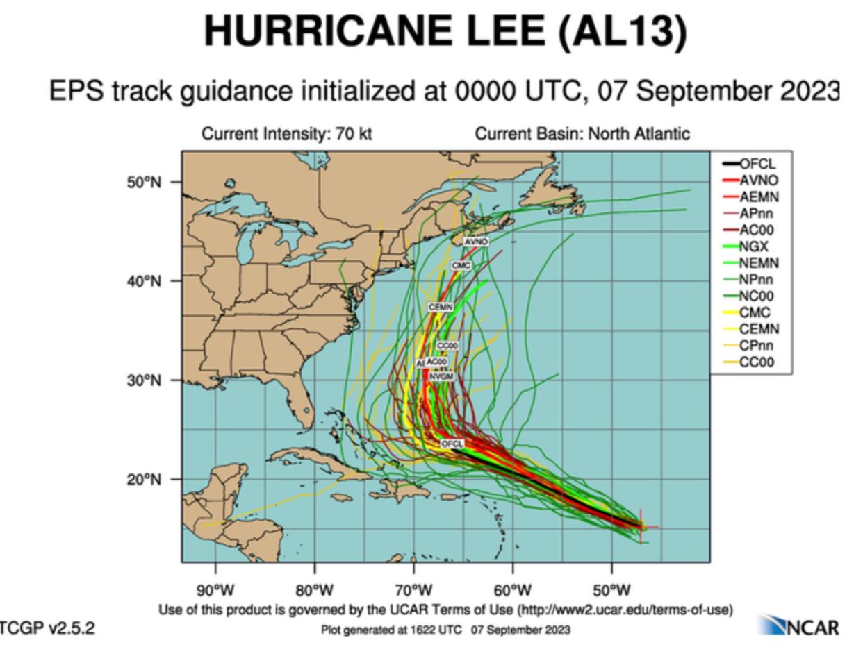
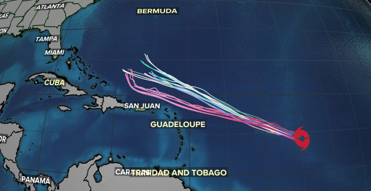
Spaghetti models show Hurricane Lee’s potential paths
Thursday 7 September 2023 22:44 , Graig Graziosi
The latest spaghetti models for Hurricane Lee show it taking a northward turn — and in some cases, a turn that takes it close to the US and Canadian East Coasts — as it travels through the Atlantic Ocean.
Hurricane Lee became a Category 4 storm on Thursday afternoon, and is forecast to become a Category 5 before it begins to slow.
Hurricane Lee intensifies from Category 2 to Category 4 in just six hours
Thursday 7 September 2023 22:19 , Graig Graziosi
Hurricane Lee, now a Category 4 storm, is now considered a major hurricane by the National Hurricane Centre.
The storm underwent rapid intensification, strengthening from a Category 2 to a Category 4 storm in just under six hours.
Forecasters believe Hurricane Lee will become a Category 5 hurricane — one of only two in recent history to form during September in an El Nino climate pattern in the Atlantic — in the coming days.
The hurricane is not forecasted to make landfall, but it may bring significant winds and storm surges to the northeast of North America as well as Puerto Rico, Hispaniola, and the Lesser Antilles.
Earth experienced hottest summer on record in 2023
Thursday 7 September 2023 22:00 , Graig Graziosi
The sweltering summer of 2023 has been officially confirmed as the “hottest summer on record” for the northern hemisphere by the United Nations.
This August was found to be about 1.5 degrees Celsius (2.7 degrees Fahrenheit) hotter than pre-industrial times, scientists from the World Meteorological Organisation (WMO) and the European climate service, Copernicus, announced on Wednesday.
The hottest August ever is also the second hottest month ever after this July, WMO said.
August marked the end of a brutal summer in the northern hemisphere with land and ocean heat records shattered across continents; extreme heatwaves and deadly wildfires.
“The dog days of summer are not just barking, they are biting,” United Nations Secretary General Antonio Guterres said in a statement. “Climate breakdown has begun.”
READ MORE:

Earth experienced ‘hottest summer on record’ in 2023, UN says
Meteorologist says eastern Canada, New Englanders are watching Hurricane Lee’s trajectory and hoping for an northeast swing
Thursday 7 September 2023 21:26 , Graig Graziosi
John Morales, NBC6’s hurricane expert, said residents of Canada’s easternmost provinces and New England in the US are likely watching Hurricane Lee’s expected trajectory as it intensifies, possibly to a Category 5 storm.
While Hurricane Lee is expected to miss landfall in the Caribbean and Florida, it may take a northward turn, which could bring its effects — like significant storm surges and high winds — to the northeastern portion of North America.
“...Residents of Canada’s easternmost provinces, and even New Englanders in the U.S., are aware of Lee and hoping that a northbound track will be followed by another turn to the northeast, sparing them,” Mr Morales said in his analysis.
What is El Nino and why is it intensifying this year’s hurricanes?
Thursday 7 September 2023 21:00 , Graig Graziosi
The UN’s World Meteorological Organisation (WMO) has announced the return of the weather cycle El Nino, which could lead to record global temperatures this year.
After three years of the cooler La Nina pattern, which often lowers global temperatures slightly, the WMO announced on Tuesday that El Nino conditions were present and are expected to gradually strengthen into the winter.
The last significant El Nino event occurred in 2016, which has gone down as the warmest year the world has seen since records began.
Its recurrence in 2023, when global heating driven by man-made carbon emissions has only accelerated, threatens a “double whammy”, according to the WMO, which has warned there is a 90 per cent probability of it lasting to the year’s end.
That means the likelihood of extreme weather events that could prove life-threatening has also increased, prompting the organisation’s officials to caution world governments that they must be prepared.
READ MORE:
What is El Nino and what impact might it have?
Hurricane Lee expected to reach Category 4 storm by this evening
Thursday 7 September 2023 20:39 , Graig Graziosi
After a day of rapid intensification, Hurricane Lee is being forecast to reach Category 4 by this evening.
The Atlantic’s warm waters — thanks to the El Nino climate pattern — are feeding Hurricane Lee, which is expected to become a Category 5 hurricane later this week.
The National Hurricane Centre reports that Hurricane Lee’s winds reached 120mph (193km/h) as of 3pm.
#LEE UPDATE 🌀 I'm expecting a major hurricane with the next update soon, NHC database has intensity right now close to 120 mph as of 3 PM. It will continue to rapidly strengthen into a Category 4 likely this evening. Details now on @WINKNews. pic.twitter.com/QEEXwhcsQp
— Matt Devitt (@MattDevittWINK) September 7, 2023
Flamingoes were flung from Florida to Ohio in Hurricane Idalia
Thursday 7 September 2023 20:09 , Graig Graziosi
Flamingos are being spotted across the continental United States in some cases thousands of miles from their usual habitats, and experts believe Hurricane Idalia is to blame.
The long-legged wading birds have been sighted as far afield as Ohio, Kentucky, the Carolinas, Virginia, Tennessee and Texas in recent days, according to Audubon Florida, a nonprofit that is tracking their movements.
Flamingos are also cropping up in parts of Florida where they are rarely seen, such as the north central Alachua County and Collier County on the southern Gulf Coast.
READ MORE:

Flamingoes were flung from Florida to Ohio in Hurricane Idalia
National Hurricane Centre warns 25 per cent chance of tropical storm-strength winds for Puerto Rico and surrounding islands
Thursday 7 September 2023 19:49 , Graig Graziosi
The National Hurricane Centre has warned there is still a 25 per cent chance that Puerto Rico and other nearby islands — including the Lesser Antilles and Hispaniola — will experience sustained tropical storm-strength winds caused by Hurricane Lee.
“The environment around the cyclone looks ideal for rapid intensification,” the NHC said. “The models are in fairly good agreement that significant strengthening should begin later today and continue into the weekend, when Lee will likely reach its peak intensity. Fluctuations in strength are likely from days three to five due to potential eyewall replacements, but Lee is still expected to be a dangerous hurricane over the southwestern Atlantic early next week.”
Hurricane Lee: Will it turn north?
Thursday 7 September 2023 19:26 , Graig Graziosi
Forecasters are unsure of if, or when, Hurricane Lee will make a turn toward the north as it continues churning across the Atlantic, but they are watching closely.
Some computer models of Hurricane Lee’s expected trajectory show a northward turn, but it’s unclear when that might happen, and if it does, how close it will bring the hurricane to the US’s east coast.
Any possible impacts on the US east coast will become more clear in the coming days as Hurricane Lee continues its trek.
Hurricane Lee: The latest update
Thursday 7 September 2023 18:47 , Louise Boyle
Hurricane Lee was about 870 miles (1405km) east of the northern Leeward Islands with winds of 105mph (165km/h), according to the 11am (eastern) update from the National Weather Service.
The hurricane is expected to rapidly intensify through today and this evening.
Hurricane-force winds are extending outwards for 25 miles (35km) from the center and tropical-storm-force winds extend outward up to 90 miles (150 km).
Swells generated by Lee are expected to reach portions of the Lesser Antilles on Friday, and reach the British and US Virgin Islands, Puerto Rico, Hispaniola, the Bahamas, and Bermuda this weekend. These swells are likely to cause life-threatening surf and rip current conditions.
Watch: Hurricane Lee rapidly strengthening
Thursday 7 September 2023 18:33 , Louise Boyle
‘Above normal'
Thursday 7 September 2023 18:04 , Louise Boyle
The National Ocean and Atmospheric Administration warned in August that this year’s season would produce an above-normal number of storms. Between 14 to 21 named storms are forecast. Of those, six to 11 could become hurricanes, with two to five of them possibly becoming major hurricanes, the agency said.
Meanwhile, AccuWeather updated its forecast, predicting there would be three to five hurricanes Category 3 or stronger this season, compared with one to three in its previous analysis.
AP
Forecasters in Puerto Rico issue a warning
Thursday 7 September 2023 17:13 , Louise Boyle
The National Weather Service office in San Juan issued a warning over the approaching Hurricane Lee on Thursday.
The hurricane currently has sustained winds of 80mph but those are forecast to increase. It’s possible that the hurricane reaches a Category 4 or 5 strength.
The forecast shows the cyclone tracking north of Puerto Rico but the island can still expect hazardous marine conditions, showers from external bands and gusty winds near strong showers, NWS said.
Watch: Hurricane Lee to keep intensifying in the days to come
Thursday 7 September 2023 16:50 , Louise Boyle
Rip current warnings
Thursday 7 September 2023 16:30 , Louise Boyle
Swells generated by Hurricane Lee are expected to reach the British and US Virgin Islands, Puerto Rico, Hispaniola, the Bahamas, and Bermuda this weekend.
The rapidly-intensifying hurricane is forecast to generate swells likely to cause life-threatening surf and rip current conditions.
Pictured: Hurricane Lee from space
Thursday 7 September 2023 16:10 , Louise Boyle
Hurricane Lee was captured by the National Oceanic and Atmospheric Administration (NOAA) satellite on Thursday as it spins towards the Leeward Islands.
‘Potential powerhouse'
Thursday 7 September 2023 15:45 , Louise Boyle
Hurricane Lee is shaping up to be an extremely dangerous hurricane, forecasters warned on Thursday.
“It has the potential to become a powerhouse Category 5 hurricane, the strongest hurricane of the year,” said Jonathan Porter, chief meteorologist for AccuWeather.
It is expected to develop into an “extremely dangerous” major hurricane by early Saturday, according to the National Hurricane Center, which noted the storm was moving over very warm water and in a moist environment.
The Associated Press
Dangerous swells, rip currents expected
Thursday 7 September 2023 15:10 , Louise Boyle
Large swells are likely to reach portions of the Lesser Antilles on Friday, according to forecasters.
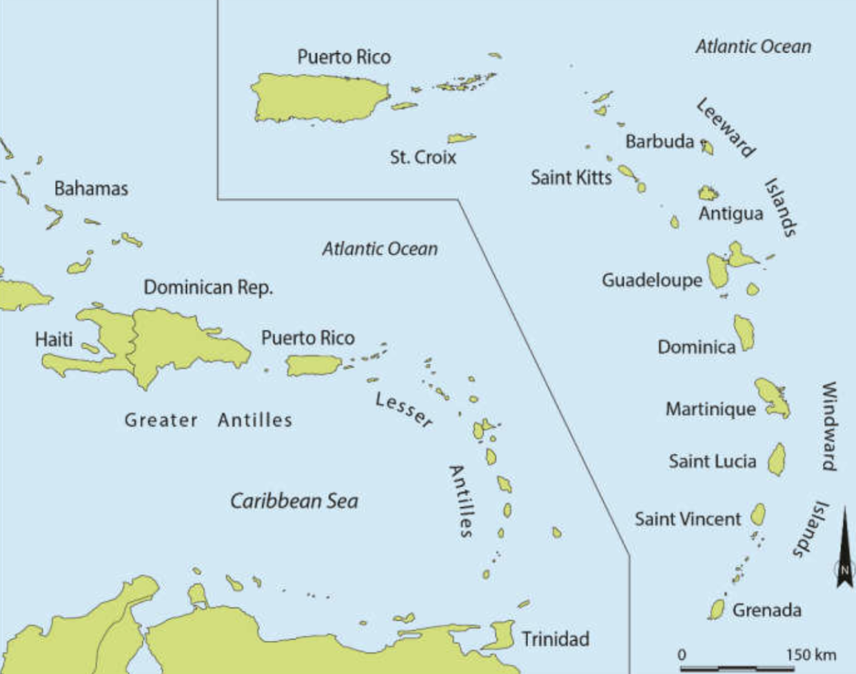
The Lesser Antilles are a long arc of small islands in the Caribbean Sea which extends from the British and US Virgin Islands to Grenada.
Watch: Hurricane Lee expected to be 'extremely dangerous'
Thursday 7 September 2023 14:45 , Louise Boyle
The latest report from the National Hurricane Center
Thursday 7 September 2023 14:19 , Louise Boyle
Hurricane Lee was rapidly strengthening on Thursday as it churned towards Caribbean islands with “life-threatening” conditions expected to develop in the coming days.
Hurricane Lee is about 965 miles (1555km) east of the northern Leeward Islands, according to the 5am (eastern time) report from the National Hurricane Center (NHC) with maximum sustained winds of 80 miles per hour (130 kph).
“Rapid intensification is expected to begin later today, and Lee is forecast to become a major hurricane by early Friday,” NHC reported.
Current projections show Hurricane Lee will not make landfall but pass north of the British Virgin Islands, which is still recovering from hurricanes Maria and Irma in September 2017.
‘Well above normal'
Thursday 7 September 2023 14:00 , Stuti Mishra
Record hot ocean temperatures and a tardy El Nino are doubling the chances of a nasty Atlantic hurricane season this summer and fall, the National Oceanic and Atmospheric Administration said last month.
With the Atlantic hurricane season already well above normal so far, NOAA increased how many storms to expect and how busy the season can get.
The agency says there’s a 60 per cent chance for an above normal hurricane season, twice the agency’s May forecast which said it was 30 per cent.
The earlier forecast leaned more toward a near normal season with a 40%, but the chance for normal has now shrunk to 25 per cent. AP
Earth experienced hottest summer on record in 2023
Thursday 7 September 2023 13:00 , Louise Boyle
The sweltering summer of 2023 has been officially confirmed as the “hottest summer on record” for the northern hemisphere by the United Nations.
This August was found to be about 1.5 degrees Celsius (2.7 degrees Fahrenheit) hotter than pre-industrial times, scientists from the World Meteorological Organisation (WMO) and the European climate service, Copernicus, announced on Wednesday.
The hottest August ever is also the second hottest month ever after this July, WMO said.
August marked the end of a brutal summer in the northern hemisphere with land and ocean heat records shattered across continents; extreme heatwaves and deadly wildfires.
“The dog days of summer are not just barking, they are biting,” United Nations Secretary General Antonio Guterres said in a statement. “Climate breakdown has begun.”
Stuti Mishra reports
Earth experienced ‘hottest summer on record’ in 2023, UN says
Hurricane Lee inches closer to Leeward Islands
Thursday 7 September 2023 12:30 , Stuti Mishra
Hurricane Lee continues to whirl through the open waters as it inches to Leeward Islands threatening to bring extreme weather.
Lee is so far not expected to make landfall on the islands while on a projected path that will take it near the northeast Caribbean, although forecasters said tropical storm conditions are possible on some islands.
The storm was located some 965 miles (1,555 kilometres) from the northern Leeward Islands, according to the latest update from the National Hurricane Center this morning/ It had winds of up to 80 miles per hour (130 kilometres per hour) and was moving west-northwest at 13 mph (20 kph).
5 am AST: Hurricane #Lee expected to rapidly intensify. Here are the latest Key Messages. https://t.co/tW4KeGe9uJ pic.twitter.com/wsvpJ69hWz
— National Hurricane Center (@NHC_Atlantic) September 7, 2023
Watch: Burning Man festival-goer shows grim conditions after flooding chaos
Thursday 7 September 2023 12:00 , Stuti Mishra
Watch: Satellite images of Hurricane Jova and Hurricane Lee
Thursday 7 September 2023 11:30 , Stuti Mishra
#Jova and #Lee 🌀🌀
Simultaneous satellite imagery of Major Hurricane Jova in the eastern Pacific (left), and strengthening Hurricane Lee in the central Atlantic (right). pic.twitter.com/VHjOlfmsJD— Zoom Earth (@zoom_earth) September 6, 2023
Billion-dollar losses from Hurricane Idalia
Thursday 7 September 2023 11:03 , Louise Boyle
The total private market insured losses from Hurricane Idalia, which struck Florida as a Category 3 storm last week, have been estimated between $3-$5 billion by Moody’s Analytics.
The risk modeling firm put the best estimate at $3.5bn for the insured losses associated with Idalia’s winds, storm surge, and flooding caused by heavy rains.
On top of this, Moody’s estimated around $500 million in losses to the National Flood Insurance Program - the US government initiative which provides affordable insurance to property owners.
Watch: Flood water gushes through Skiathos road as intense rain hits Greece
Thursday 7 September 2023 10:30 , Louise Boyle
Spain floods: Rescuers dig car out of mud in desperate search for missing men swept away by water
Thursday 7 September 2023 10:02 , Louise Boyle
Rescuers are hunting for two missing men after Storm Dana savaged Spain and killed three people.
Record rainfall caused heavy flooding in central Spain on Monday, shutting roads, subway lines and high-speed train connections.
Footage has captured emergency services in Madrid frantically digging out a car completely submerged in mud.
Rescuers are still searching for a middle-aged man after his car was swept away by a river when he was travelling with his wife and children. An 83-year-old man was also swept away by the current.

Spain floods: Rescuers dig car out of mud in search for men swept away by water
Hurricane Jova's 'explosive rapid intensification' turns it into a Category 5 storm
Thursday 7 September 2023 09:34 , Stuti Mishra
While the Caribbean and the southeast coast of the US have their eyes on Hurricane Lee, another storm, Hurricane Jova has rapidly intensified into a Category 5 hurricane in the eastern Pacific.
Hurricane Jova is now officially Category 5 and still intensifying in Eastern Pacific 🌀📈. No threat to land.
Over the weekend, I remember looking at guidance while it was an INVEST and thinking nothing of it. I have no idea why this system blew up to Category 5. pic.twitter.com/Q3ryeL6Uhe— Ryan Maue (@RyanMaue) September 7, 2023
"That is one of the most rapid intensification rates ever observed in a hurricane. It may gain a little more intensity overnight," wrote meteorologist Craig Ceecee.
Meanwhile, in the Pacific, #Jova has put on a show - in 24 hours, the winds have increased from 70 mph to 160 mph and it is now a category 5 hurricane. That is one of the most rapid intensification rates ever observed in a hurricane. It may gain a little more intensity overnight. pic.twitter.com/jqK5YAa25O
— Craig Ceecee, Ph.D. (@CC_StormWatch) September 7, 2023
Hurricane Lee spaghetti models show path storm could take
Thursday 7 September 2023 09:01 , Stuti Mishra
Hurricane Lee currently is expected to pass near the northern Leeward Islands and Puerto Rico this weekend and then take a northward turn away from Florida, according to the projections.
However, the spaghetti models, that depicts various paths the storm could potentially take going forward, show a lot of uncertainty.
While National Hurricane Center has said it is too soon to predict whether Lee will make a direct landfall in Florida or not, it is getting more clear that the storm would definitely grow into an "extremely dangerous" Category 5 storm and could still potentially bring some impact to the US even if it doesn't make a landfall.
The models shared by experts tracking the storm on Twitter show several scenarios where the hurricane could once again come very close to the US coast, even though there is a pretty reliable consensus that the storm will track northwest.
These maps, resembling long strands of pasta which gives it its name, show some potential paths that come towards Florida, while most go northwest.
Latest Wednesday 12z EURO spaghetti models. Keeping consistent. Bermuda watching close. East Coast scenarios still there to keep aware this next week on Hurricane Lee's path. https://t.co/Hk3pbO7x8H pic.twitter.com/8DlpI7btVg
— Mike's Weather Page (@tropicalupdate) September 6, 2023
However, what is worrying experts is that there is a lot of spread in potential paths of the hurricane beyond this weekend, which indicates uncertainty.
#HurricaneLee will be making headlines for a *long* time. pic.twitter.com/wWwvpm6EDe
— Greg Postel (@GregPostel) September 7, 2023
Hurricane Lee's rapid intensification 'expected to begin tomorrow'
Thursday 7 September 2023 08:15 , Stuti Mishra
Lee, which intensified into a Category 1 hurricane from a tropical storm on Wednesday evening, is going to go through a more raping strengthening process starting on Thursday, experts warn.
The storm is feared to grow into an "extremely dangerous" Category 5 hurricane by Friday, due to warmer than usual waters in Atlantic.
"The rapid intensification is expected to begin tomorrow, and by the weekend, it should be a category 4 or 5 hurricane," meteorologist Craig Ceecee wrote on X, formerly known as Twitter.
"The track is good confidence through Monday, but beyond that, all bets are off. Too soon to think about US landfall possibilities."
#Lee now has 80 mph winds. The rapid intensification is expected to begin tomorrow, and by the weekend, it should be a category 4 or 5 hurricane. The track is good confidence through Monday, but beyond that, all bets are off. Too soon to think about US landfall possibilities. pic.twitter.com/a1xjoRAD62
— Craig Ceecee, Ph.D. (@CC_StormWatch) September 7, 2023
Where is Hurricane Lee heading?
Thursday 7 September 2023 07:22 , Stuti Mishra
Hurricane Lee is expected to pass near the northern Leeward Islands and Puerto Rico this weekend. The Leeward Islands are a group of islands located where the Caribbean Sea meets the western Atlantic Ocean and include the US Virgin Islands.
Large ocean swells are expected to reach the Lesser Antilles by Friday, and then the US and British Virgin Islands, Puerto Rico, the Bahamas, Bermuda and Hispaniola by the weekend, the hurricane center said.
Where is Hurricane Lee now?
Thursday 7 September 2023 06:37 , Stuti Mishra
Hurricane Lee was located about 1,130 miles (1,815km) east of the northern Leeward Islands late on Wednesday, according to the latest NHC update.
It had maximum sustained winds of 75mph (120 kph) and was moving west-northwest at 14mph (22kph).
The storm is expected to become a "major hurricane" by Friday, the NHC said, as the storm intensifies at a "steady to rapid" pace. It may become a Category 4 hurricane – a potentially "catastrophic" storm with sustained wind speeds of 130-156 mph – as it travels over very warm water.
Hurricane Lee to become 'extremely dangerous' by Friday, latest NHC update says
Thursday 7 September 2023 06:19 , Stuti Mishra
Lee, which intensified into a hurricane on Wednesday evening, is likely to become a Category 5 "extremely dangerous" hurricane by Friday, a day earlier than previously anticipated, the latest update from National Hurricane Center (NHC) said.
The Miami-based centre warned that the large ocean swells will likely reach the Lesser Antilles, the Virgin Islands, and Puerto Rico by the weekend.
Hurricane #Lee Advisory 7: Lee Forecast to Become an Extremely Dangerous Major Hurricane By Friday. Large Ocean Swells Likely to Reach the Lesser Antilles, the Virgin Islands, and Puerto Rico Through the Weekend. https://t.co/tW4KeGe9uJ
— National Hurricane Center (@NHC_Atlantic) September 7, 2023
How Tropical Storm Lee looks from space
Thursday 7 September 2023 05:30 , Stuti Mishra
Tropical Storm Lee was captured from space on Wednesday.
The vast system was seen moving through the Caribbean in imagery shared by the Cooperative Institute for Research in the Atmosphere (CIRA) at Colorado State University. Lee was expected to gain hurricane status on Wednesday.
This morning's view of Tropical Storm Lee.
Lee nears hurricane status, likely becoming one later today. pic.twitter.com/26OS7Jm6Pk— CIRA (@CIRA_CSU) September 6, 2023
Earth experienced hottest summer on record in 2023
Thursday 7 September 2023 05:04 , Louise Boyle
Earth experienced hottest summer on record in 2023, UN says
The sweltering summer of 2023 has been officially confirmed as the hottest summer on record for the northern hemisphere by the United Nations.
This August was found to be about 1.5 degrees Celsius (2.7 degrees Fahrenheit) hotter than pre-industrial times, scientists from the UN agency, the World Meteorological Organisation (WMO), and the European climate service, Copernicus, announced on Wednesday.
The record-breaking August is also the second hottest month ever after this July, WMO said.
August marked the end of a brutal summer in the northern hemisphere with land and ocean heat records shattered across continents; extreme heatwaves and deadly wildfires.
Hotter ocean temperatures are also fuelling stronger hurricanes in the Atlantic, scientists say.
Stuti Mishra reports
Earth experienced ‘hottest summer on record’ in 2023, UN says
Mapped: The path and timeline for Tropical Storm Lee
Thursday 7 September 2023 04:02 , Louise Boyle
Tropical Storm Lee: What are spaghetti models?
Thursday 7 September 2023 03:02 , Louise Boyle
Spaghetti models get their name from how they look - a jumble of squiggly lines.
In fact, what looks like hurried drawings are actually computer models tracking the potential paths of a tropical storm or hurricane.
The more that the “spaghetti strands” lie close together or overlap, means the greater the confidence in the forecast. Further apart lines indicate more uncertainty.
Storm Lee makes a dozen
Thursday 7 September 2023 02:05 , Louise Boyle
Tropical Storm Lee is the 12th named storm to form in the Atlantic Ocean in 2023.
The Atlantic hurricane season, which runs from 1 June to 30 November, is forecast to be above average this year. Late August and early September are typically the season’s peak.

Leeward Island possibly first to be impacted by Tropical Storm Lee
Thursday 7 September 2023 01:03 , Louise Boyle
Tropical Storm Lee “could bring impacts to the Leeward Islands”, the National Hurricane Center has warned, urging residents to keep an eye on updates.
“It is becoming a question of when and not if rapid intensification occurs with Lee,” the advisory noted. Winds are forecast to reach 145 mph which is a powerful Category 4 “major hurricane.”
‘While it is too soon to determine the location and magnitude of these possible impacts, interests in this area should monitor the progress of the depression and updates to the forecast,” the NHC said.
Watch: Satellite footage shows Storm Lee as weather system expected to become hurricane
Thursday 7 September 2023 00:03 , Louise Boyle
Flamingos are cropping up thousands of miles from their homes after Hurricane Idalia
Wednesday 6 September 2023 23:01 , Louise Boyle
Flamingos are being spotted across the continental United States, in some cases thousands of miles from their usual habitats, and experts believe Hurricane Idalia is to blame.
The long-legged wading birds have been sighted in Ohio, Kentucky, the Carolinas, Virginia, Tennessee and Texas in recent days, according to Audubon Florida, a conservation nonprofit tracking their movements.
Flamingos are also cropping up in parts of Florida where they are rarely seen like the north central Alachua County and Collier County on the southern Gulf Coast.
Audubon Florida’s state director for research Jerry Lorenz told CNN the distinctive pink birds may have been flying from Cuba to the Yucatan peninsula in Mexico when they were blown off course by Idalia.
“We have never seen anything like this,” Mr Lorenz said, adding that fresh sightings were continuing to pour in.
Bevan Hurley reports
Flamingos are cropping up thousands of miles from their homes after Hurricane Idalia
Breaking: Storm Lee strengthens to a hurricane
Wednesday 6 September 2023 22:21 , Louise Boyle
Tropical Storm Lee strengthened to a hurricane on Wednesday afternoon and is expected to build into an “extremely dangerous” storm by early Saturday, forecasters warned.
Hurricane Lee is about 1130 miles (1815km) east of the northern Leeward Islands, according to the 5pm (eastern time) report from the National Hurricane Center, with maximum sustained winds of 75 miles per hour (120 kph).
Current projections show Hurricane Lee will not make landfall but pass north of the British Virgin Islands, which is still recovering from hurricanes Maria and Irma in September 2017.
Lee is the 12th named storm of the Atlantic hurricane season, which runs from June 1 to November 30.
What are the major hurricane hazards?
Wednesday 6 September 2023 22:02 , Louise Boyle
The main hazards from tropical cyclones - the catch-all term for tropical depressions, tropical storms, and hurricanes - are storm surge flooding, inland flooding from heavy rains, destructive winds, tornadoes, and high surf and rip currents, according to the National Weather Service.
- Storm surge can travel several miles inland, especially along bays, rivers, and estuaries.
- Flooding from heavy rains is the second leading cause of fatalities from landfalling tropical cyclones. Widespread torrential rains associated with these storms often cause flooding hundreds of miles inland. This flooding can persist for several days after a storm has dissipated.
- Winds from a hurricane can destroy buildings and manufactured homes. Signs, roofing material, and other items left outside can become flying missiles during hurricanes.
- Tornadoes can accompany landfalling tropical cyclones. These tornadoes typically occur in rain bands well away from the center of the storm.
- Dangerous waves produced by a tropical cyclone’s strong winds can pose a significant hazard to coastal residents and mariners. These waves can cause deadly rip currents, significant beach erosion, and damage to structures along the coastline, even when the storm is more than a 1,000 miles offshore.
National Weather Service
Watch: Lee could become Cat 5 hurricane soon
Wednesday 6 September 2023 21:35 , Louise Boyle
Tropical Storm Lee: What are spaghetti models?
Wednesday 6 September 2023 21:01 , Louise Boyle
Spaghetti models get their name from how they look - a jumble of squiggly lines.
In fact, what looks like hurried drawings are actually computer models tracking the potential paths of a tropical storm or hurricane.
The more that the “spaghetti strands” lie close together or overlap, means the greater the confidence in the forecast. Further apart lines indicate more uncertainty.
‘Life-threatening surf and rip currents'
Wednesday 6 September 2023 19:44 , Louise Boyle
The National Hurricane Center warned of “life-threatening surf and rip currents” across portions of the Lesser Antilles later this week as Tropical Storm Lee grows into a major hurricane.
11AM AST Sep 6: #Lee is forecast to become a major hurricane by early Saturday. Swells are likely to cause life-threatening surf and rip currents across portions of the Lesser Antilles late this week. Stay up to date with the latest at https://t.co/tW4KeGdBFb pic.twitter.com/2CVr855fan
— National Hurricane Center (@NHC_Atlantic) September 6, 2023
Watch: Satellite footage shows Storm Lee as weather system expected to become hurricane
Wednesday 6 September 2023 19:10 , Louise Boyle
FEMA issues warning over Tropical Storm Lee
Wednesday 6 September 2023 18:39 , Louise Boyle
The US Federal Emergency Management Agency (FEMA) issued a warning on Tropical Storm Lee on Wednesday as it looked set to become a major hurricane by the weekend.
“Make sure you have different ways to receive weather alerts and prepare in advance if it’ll affect your area,” FEMA said.
Tropical Storm #Lee could become a major hurricane by this weekend. Make sure you have different ways to receive weather alerts and prepare in advance if it’ll affect your area.
Preparedness tips: https://t.co/rfjUqvcppP https://t.co/sbnhc30UNq pic.twitter.com/C4yJJwFPLN— FEMA (@fema) September 6, 2023
How Tropical Storm Lee looks from space
Wednesday 6 September 2023 18:10 , Louise Boyle
Tropical Storm Lee was captured from space on Wednesday.
The vast system was seen moving through the Caribbean in imagery shared by the Cooperative Institute for Research in the Atmosphere (CIRA) at Colorado State University. Lee is expected to gain hurricane status later today.
This morning's view of Tropical Storm Lee.
Lee nears hurricane status, likely becoming one later today. pic.twitter.com/26OS7Jm6Pk— CIRA (@CIRA_CSU) September 6, 2023
Billion-dollar losses from Hurricane Idalia
Wednesday 6 September 2023 17:40 , Louise Boyle
The total private market insured losses from Hurricane Idalia, which struck Florida as a Category 3 storm last week, have been estimated between $3-$5 billion by Moody’s Analytics.
The risk modeling firm put the best estimate at $3.5bn for the insured losses associated with Idalia’s winds, storm surge, and flooding caused by heavy rains.
On top of this, Moody’s estimated around $500 million in losses to the National Flood Insurance Program - the US government initiative which provides affordable insurance to property owners.
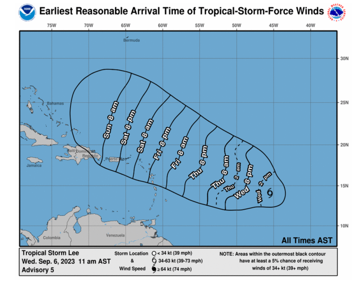
Arrival times of tropical storm-force winds
Wednesday 6 September 2023 17:11 , Louise Boyle
Hurricane Jova develops in Pacific
Wednesday 6 September 2023 16:38 , Louise Boyle
In the Pacific Ocean, Jova strengthened into a Category 2 hurricane far off the southwest coast of Mexico and posed no threat to land.
It was located some 600 miles south of Baja California and moving west-northwest at 13 mph with winds up to 105mph.
It was expected to become a major hurricane by Wednesday night.
The Associated Press
Earth experienced hottest summer on record in 2023, UN says
Wednesday 6 September 2023 16:00 , Louise Boyle
The sweltering summer of 2023 has been officially confirmed as the hottest summer on record for the northern hemisphere by the United Nations.
This August was found to be about 1.5 degrees Celsius (2.7 degrees Fahrenheit) hotter than pre-industrial times, scientists from the UN agency, the World Meteorological Organisation (WMO), and the European climate service, Copernicus, announced on Wednesday.
The record-breaking August is also the second hottest month ever after this July, WMO said.
August marked the end of a brutal summer in the northern hemisphere with land and ocean heat records shattered across continents; extreme heatwaves and deadly wildfires.
Hotter ocean temperatures are also fuelling stronger hurricanes in the Atlantic, scientists say.
Stuti Mishra reports
Earth experienced ‘hottest summer on record’ in 2023, UN says
Watch: US and Caribbean on alert for growing tropical system
Wednesday 6 September 2023 15:31 , Louise Boyle
What is the path of Tropical Storm Lee?
Wednesday 6 September 2023 15:00 , Louise Boyle
Tropical Storm Lee churned through the open waters of the Atlantic on Wednesday and was expected to soon become a hurricane as it approached the Caribbean.
The storm was located about 1,265 miles (2,040 kilometers) east-southeast of the northern Leeward Islands. It had maximum sustained winds of 65 mph (100 kph) and was moving west-northwest at 14 mph (22 kph), according to the National Hurricane Center.
It was not forecast to make landfall, but it is projected to pass just northeast of the British Virgin Islands, which is still recovering from hurricanes Maria and Irma that hit in September 2017.
The Associated Press
Storm Lee makes a dozen
Wednesday 6 September 2023 14:33 , Louise Boyle
Tropical Storm Lee is the 12th named storm to form in the Atlantic Ocean in 2023.
The Atlantic hurricane season, which runs from 1 June to 30 November, is forecast to be above average this year. Late August and early September are typically the season’s peak.
Watch: Hurricane Lee nears hurricane strength
Wednesday 6 September 2023 14:08 , Louise Boyle
Tropical Storm Lee is approaching hurricane strength
Wednesday 6 September 2023 13:52 , Louise Boyle
The 5am (eastern time) report from the National Hurricane Center notes that Lee is “approaching hurricane strength”.
Path of Tropical storm Lee: Where is the storm currently and where will it head?
Wednesday 6 September 2023 12:15 , Stuti Mishra
Tropical storm Lee was located some 1,230 miles (1,980km) east of the Lesser Antilles a few hours ago with maximum sustained winds of 50mph (85kph).
The projected path of the tropical storm, according to NHC, shows it was moving west-northwest at 16mph (26kph) and could reach the Caribbean by this weekend.
Tropical Storm Lee 'approaching hurricane strength', says NHC
Wednesday 6 September 2023 11:15 , Stuti Mishra
Tropical Storm Lee is soon “approaching hurricane strength” before it further intensifies and becomes an “extremely dangerous” Category 5 hurricane by this weekend, according to the latest update from National Hurricane Center.
Tropical Storm #Lee Advisory 4: Lee Approaching Hurricane Strength. Expected to Rapidly Intensify Into an Extremely Dangerous Hurricane By the Weekend. https://t.co/tW4KeGe9uJ
— National Hurricane Center (@NHC_Atlantic) September 6, 2023
Hurricanes are getting stronger. Here’s why
Wednesday 6 September 2023 10:15 , Stuti Mishra

Hurricanes are getting stronger. Here’s why
'This isn't good': Tropical Storm Lee forecast to move more 'westerly and southerly',
Wednesday 6 September 2023 09:33 , Stuti Mishra
New projections are showing that Tropical Storm Lee could take a more "westerly and southerly" route than predicted previously, which means slightly increased chances of the storm heading closer to the Caribbean.
Earlier the storm, which could intensify to Category 5, was forecast to turn northwards.
Eric Feigl-Ding, an epidemiologist and health economist said this change is "worrisome".
"This isn’t good—not only is there worries by some that Hurricane #Lee might become a Category 5 storm, but models are now showing a much more westerly and southerly than before (earlier models said would head more north). This is worrisome," he wrote on X, previously known as Twitter.
🌀This isn’t good—not only is there worries by some that Hurricane #Lee might become a Category 5 storm, but models are now showing a much more westerly and southerly than before (earlier models said would head more north). This is worrisome.pic.twitter.com/UEZemm9rFx
— Eric Feigl-Ding (@DrEricDing) September 6, 2023
Leeward Islands could be first to be impacted by Tropical Storm Lee
Wednesday 6 September 2023 09:00 , Stuti Mishra
Tropical Storm Lee "could bring impacts to the Leeward Islands", the National Hurricane Center has warned, urging residents to keep an eye on updates.
"It is becoming a question of when and not if rapid intensification occurs with Lee," the advisory noted. Winds are forecast to reach 145 mph which is a powerful Category 4 "major hurricane."
'While it is too soon to determine the location and magnitude of these possible impacts, interests in this area should monitor the progress of the depression and updates to the forecast," the NHC said.
Tropical Depression Thirteen - forecast to become Tropical Storm Lee later today - is also forecast to become a major hurricane by this weekend and could bring impacts to the Leeward Islands by that time. While it is too soon to determine the location and magnitude of these… pic.twitter.com/5rP5ZNvxfc
— National Weather Service (@NWS) September 5, 2023
Satellite footage shows how Lee intensified into a storm
Wednesday 6 September 2023 08:31 , Stuti Mishra
This is Tropical Storm #Lee.
A magnificent example of how a tropical wave from the western coast of Africa can develop into a tropical storm in just 5 days. pic.twitter.com/qfuTqj75W2— Zoom Earth (@zoom_earth) September 5, 2023
Another storm brews in the Pacific
Wednesday 6 September 2023 08:00 , Stuti Mishra
As tropical storm Lee is set to intensify in the Atlanic, in the Pacific, tropical storm Jova is continuing to strengthen well off the southwest coast of Mexico, but posed no threat to land yet.
Jova had 70mph (110kmh) winds and was forecast to become a hurricane today, according to the National Hurricane Center. It was about 675 miles (1,085kms) south of the southern tip of Baja California and moving west-northwest at 9mph (15kph).
How extreme ocean temperatures have made this hurricane season more dangerous?
Wednesday 6 September 2023 07:30 , Stuti Mishra
Tropical storm Lee is churning in the Atlantic, once again threatening the Caribbean and the US southeast coast, less than a week after Florida was battered by Category 3 Hurricane Idalia.
The remnants of Idalia, and another hurricane, Franklin, were causing strong ocean rip currents along the mid-Atlantic coast with at least eight deaths reported over the Labor Day holiday weekend.
The Atlantic hurricane season, which runs from 1 June to 30 November, is forecast to be above average this year.
Between 14 to 21 named storms are forecast. Of those, six to 11 could become hurricanes, with two to five of them possibly becoming major hurricanes. Late August and early September are typically the season’s peak.
Ocean temperatures have hit historic highs this summer. Warming oceans fuel stronger tropical cyclones that bring more heavy rainfall and higher storm surge when they make landfall, according to Climate Central.
Will Tropical storm Lee make landfall in the Caribbean or the US?
Wednesday 6 September 2023 07:10 , Stuti Mishra
Preliminary forecasts are not predicting any landfall, although the centre warned that “it is too early to determine exactly how close this system will be to the Leeward Islands.”
Tropical storm Lee could become Category 5 'extremely dangerous' storm
Wednesday 6 September 2023 06:50 , Stuti Mishra
Tropical storm Lee is forecast to strengthen into an "extremely dangerous" hurricane by Friday as it moves over very warm waters and pass just northeast of the Caribbean region, the centre said.
Meteorologist Ryan Maue suggested on X, formerly Twitter, that Lee could become a “monstrous storm” in the Category 4 or 5 range but travel “safely north” of the Leeward Islands and Puerto Rico.
Colin McCarthy, whose Twitter account US Stormwatch follows extreme weather globally, also wrote “the storm could reach historically strong levels” as it moves through “Atlantic waters still at record hot levels.”
Tropical Storm #Lee will likely become the first Category 5 hurricane in the Atlantic in 2023 this weekend as it explosively intensifies.
Some hurricane models suggest the storm could reach historically strong levels (170+ mph) as it moves through a low wind shear environment… pic.twitter.com/Kip1XZkkwb— Colin McCarthy (@US_Stormwatch) September 6, 2023
Path of Tropical storm Lee: Where is the storm currently and where will it head?
Wednesday 6 September 2023 06:31 , Stuti Mishra
Tropical storm Lee was located some 1,230 miles (1,980km) east of the Lesser Antilles a few hours ago with maximum sustained winds of 50mph (85kph).
The projected path of the tropical storm, according to NHC, shows it was moving west-northwest at 16mph (26kph) and could reach the Caribbean by this weekend.
Wednesday 6 September 2023 06:13 , Stuti Mishra
Tropical Storm Lee was announced by the National Hurricane Center (NHC) at 5pm (eastern time) on Tuesday.
It is expected to intensify into an “extremely dangerous” hurricane by the weekend. Read more:

Tropical Storm Lee expected to become ‘extremely dangerous’ hurricane by weekend
Wednesday 6 September 2023 05:58 , Stuti Mishra
Welcome to The Independent’s live blog on tropical storm Lee churning in the Atlantic Ocean, Stay tuned for the latest forecasts and updates.
