How do NC officials manage water levels in local lakes ahead of a storm? What to know
When heavy rainfalls are expected, stormwater managers throughout the region start looking at how full their lakes are and whether they need to bring water levels down.
“It is a very much a balancing act between what’s coming in, how much we can hold at each of our lakes and our floodpool, and then when is it safe to start releasing that water,” Dana Matics, the U.S. Army Corps of Engineers’ Piedmont assistant operations project manager, told The News & Observer.
The Corps spent last week steadily lowering Falls and Jordan lakes to their normal levels in response to a rainy December, while City of Raleigh officials increased their own releases at Lake Johnson. Both steps will create more capacity for key reservoirs to hold water from the heavy rains anticipated Tuesday.
Lowering Lake Johnson’s water levels
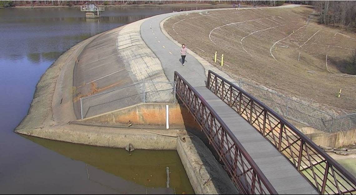
Lake Johnson is the key reservoir controlled by the City of Raleigh.
Last Wednesday the lake was full, with water running into its spillway, Kelly Daniel, the city’s flood early warning system engineer, told The N&O. Water around Cary drains into Lake Johnson, with an inch of rainfall typically raising the lake one foot.
Looking at forecasts for Saturday’s rainfall and the storm that is still expected Tuesday, Daniel and other Raleigh officials realized they would need more room to contain anticipated rainfall.
“One of the main reasons we lower Lake Johnson is to help capture that additional runoff from the Cary area and upstream of Lake Johnson and not release additional flow downstream in Walnut Creek,” Daniel said.
The lake is near the headwaters of Walnut Creek, and there are flood-prone areas downstream.
Daniel pays particular attention to the neighborhood off of Rose Lane south of Walnut Creek and north of Interstate 40. Rose Lane is prone to flooding there, and it is also the only way in and out of the neighborhood.
When about three inches of rain fall, Daniel said, “It has a good possibility of flooding that roadway or starting to flood that roadway if we do not lower Lake Johnson.”
If Raleigh officials hadn’t lowered Lake Johnson from its full capacity, Daniel said, Saturday’s rainfall and Tuesday’s expected storm could have easily sent two to three feet of water cascading over the spillway and into Walnut Creek.
“What we’re trying to do is reduce the amount of water that will be going down the creek,” Daniel said.
Data from the U.S. Geological Survey indicate that Lake Johnson’s levels fell about 3.75 feet from Jan. 3 to Monday afternoon.
How do Raleigh officials lower water levels?
When Daniel and other Raleigh officials decide the reservoir needs to be lowered, they open a gate on a tower near Lake Johnson’s dam.
City officials used to open the gate by taking a boat to the tower structure and manually turning a valve, but now they’re able to do this by computer or phone.
The releases typically happen around tropical storms or hurricanes, Daniel said, but this week’s expected heavy rainfall comes after a wet December that caused the lake to fill.
The coming storm
A line of strong to severe thunderstorms are expected to reach the Triangle between 2 and 10 p.m. Tuesday, according to the National Weather Service.
Those storms could result in 1.5 to 2 inches of rain, with higher levels falling around Greensboro and Asheboro. Forecasters are warning that those rains could result in some mild to moderate river flooding, as well as flash floods.
Peak wind gusts in Raleigh and Durham are expected to reach about 40 miles per hour Tuesday.
What about Falls and Jordan lakes?
The U.S. Army Corps of Engineers steadily lowered both Falls and Jordan lakes throughout the first week of January, but that wasn’t directly to prepare for the anticipated storm.
Matics said the Corps was steadily lowering the two lakes to their normal levels following a rainy December.
In December, a weather station at Falls Lake recorded 7.73 inches of precipitation.
That was the second-wettest month of 2023. It was also the eighth-wettest month at the station since January 2018.
The Corps is wary of lowering its lakes below their normal levels ahead of storms. Both Falls and Jordan lakes are key drinking water sources for the Triangle, and each flows into a major river that traverses Eastern North Carolina.
“If the rain doesn’t fall where we think it’s going to then we have low lake levels and we’ve sent a slug of water downstream that maybe they weren’t ready for,” Matics said.
This story was produced with financial support from the Hartfield Foundation and Green South Foundation (formerly 1Earth Fund), in partnership with Journalism Funding Partners, as part of an independent journalism fellowship program. The N&O maintains full editorial control of the work.
