South Florida is already feeling Tropical Storm Nicole. How bad will it get?
South Florida is forecast to see a steady stream of rain for much of Wednesday as a strengthening Tropical Storm Nicole treks closer to Florida’s east coast.
The National Hurricane Center’s forecast is calling for Nicole to be at or near Category 1 hurricane-level strength before making landfall late Wednesday or early Thursday on Florida’s east coast, possibly near the Palm Beach-Martin County border.
However, forecasters are cautioning that people shouldn’t focus on Nicole’s exact track. Nicole is a large storm, with its tropical storm-force winds extending up to 460 miles from its center, especially north of the center. This means its impact will be felt far out of the cone, stretching into Miami-Dade and Broward counties.
And Nicole is forecast to bring heavy rain, strong winds and dangerous storm surge to the state.
READ MORE: Is my Florida flight canceled or delayed because of Tropical Storm Nicole? How to check
So, when will South Florida feel the worst of Nicole’s wind and rain?
The National Weather Service in Miami expects Miami-Dade and Broward counties will see the worst weather Wednesday afternoon through the night. The Keys will too. Palm Beach County and other parts of Florida will feel the brunt of Nicole Wednesday night into Thursday morning.
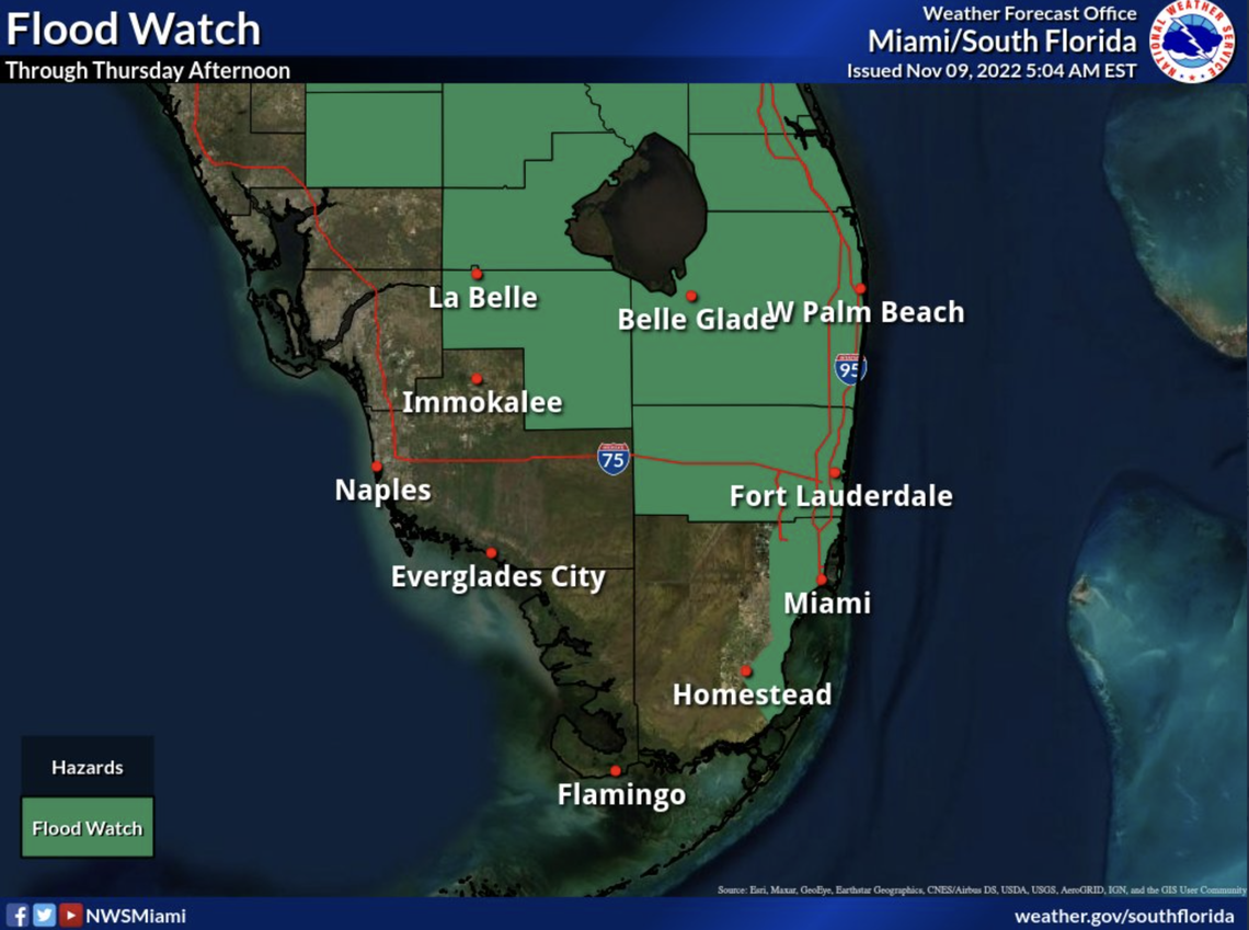
Much of South Florida is under a flood watch through at least Thursday afternoon, with Miami-Dade under a tropical storm watch and Broward under a tropical storm warning, with a hurricane watch in effect from Hallandale Beach to Boca Raton in Palm Beach County. A coastal flood statement remains in effect for the Florida Keys. Palm Beach County is under a hurricane warning and most of Florida’s east coast, and parts of Florida’s west coast, are under storm surge watches and warnings.
Here’s what type of weather to expect in South Florida:
How much rain will Nicole bring to South Florida?
The National Weather Service in Miami expects Miami-Dade and Broward counties will see 2 to 4 inches of rain, with some isolated areas possibly seeing up to 6 inches of rain. The highest rain amounts will likely be across Palm Beach County.
In the Keys, up to 2 inches of rain could be possible, with the higher rain amount likely to occur in the Upper Keys, according to the National Weather Service in Key West.
Wednesday’s rain chance: 80% in Miami-Dade, 90% in Broward and Palm Beach counties. For the Florida Keys, there’s an 80% chance of rain for the Upper Keys and a 70% chance of rain in the Middle and Lower Keys.
How strong will Nicole’s winds be?
Miami-Dade is expected to feel tropical-storm-force winds ranging from 39 to 57 mph, according to the National Weather Service. In Broward, it depends on where you are.
Some parts of Broward County, such as Fort Lauderdale, Hollywood, Plantation, Pembroke Pines and Miramar, could see tropical storm-force winds as strong as 57 mph, according to the weather service. If you go more north in Broward, such as Pompano Beach, Coral Springs, Tamarac, North Lauderdale, Parkland, and Deerfield Beach, tropical storm-force winds could get as strong as 73 mph. This is just on the cusp of hurricane-force winds, which are considered to be at least 74 mph.
Remember, Broward is under a hurricane watch, which means it’s possible some parts of the county might feel hurricane-force winds. Some parts of Broward may also see a few tornadoes.
Similarly, some parts of Palm Beach County, such as Boca Raton, Boynton Beach, and Royal Palm Beach could see tropical storm force winds as strong as 73 mph, nearly at hurricane strength. Other parts of Palm Beach County, such as West Palm Beach, Jupiter and Riviera Beach, could see winds as strong as 110 mph, which is the equivalent of a Category 2 hurricane, according to the weather service’s “Threats and Impacts” webpage.
Remember, Palm Beach County is under a hurricane warning, which means it’s possible parts of the county will feel hurricane-force winds. The weather service says you should plan for possible Cat 1 or 2 hurricane-force winds. Some parts of Palm Beach County may also see a few tornadoes.
The least wind will be felt in the Keys, which could possibly see 20-25 mph winds with gusts up to 35 mph all along the island chain through Wednesday night, according to the weather service in Key West.
And here are the latest threat and impacts graphics for this morning's 4am advisory. Main change from the previous issuance is the high wind threat being extended into western Palm Beach County. pic.twitter.com/gLlFrM5JPx
— NWS Miami (@NWSMiami) November 9, 2022
What about Nicole’s storm surge?
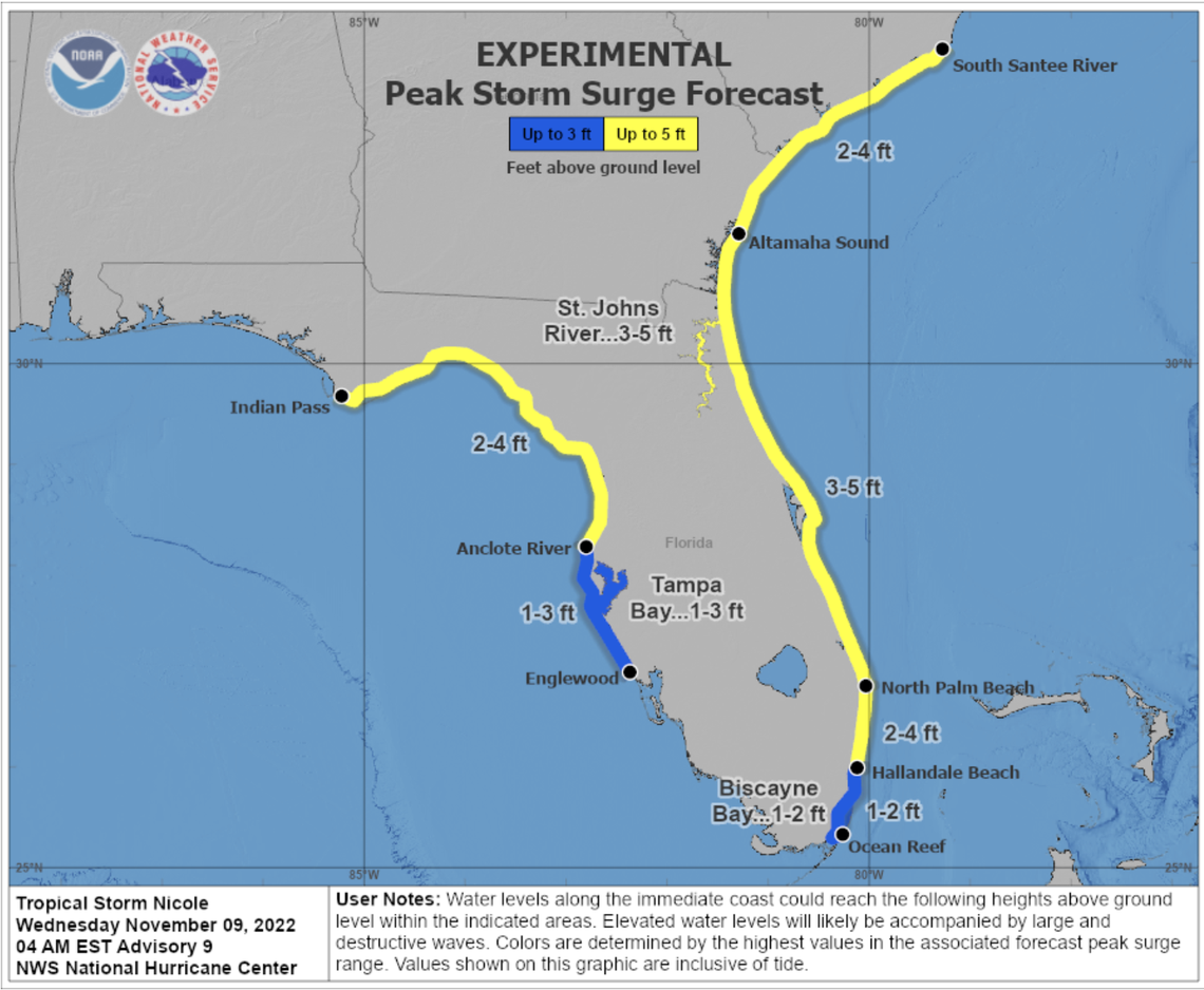
The National Hurricane Center expects the most storm surge, 3 to 5 feet, will occur from North Palm Beach to Altamha Sound, Georgia, including Florida’s St. Johns River to the Fuller Warren Bridge in Jacksonville.
For South Florida, the hurricane center expects 2 to 4 feet of storm surge will occur from Broward’s Hallandale Beach to North Palm Beach. The center forecasts 1 to 2 feet of storm surge will be possible from coastal Miami-Dade to Hallandale Beach, including Biscayne Bay.
In the Keys, storm surge isn’t expected, though there could be some significant street and yard flooding, the weather service said.
Coastal flooding in addition to King Tides will be maximized today and tonight high tides, with another round possible Thursdaynight. Total water levels 1.5 to 2.5 feet above mean higher waterare possible, or about a half foot to a foot higher than Mondaynight`s high tide. Gulf and Bayside communities exposed to thenorth will experience the highest tides.
Flooding in the Keys?
The Key West weather service says significant street and yard flooding will be possible Wednesday along the island chain due to coastal flooding and king tides. A coastal flood statement remains in effect for the Florida Keys.
“Coastal flooding in addition to King Tides will be maximized today and tonight high tides, with another round possible Thursday night. Total water levels 1.5 to 2.5 feet above mean higher water are possible, or about a half foot to a foot higher than Monday night’s high tide,” according to the Key West weather service’s hazardous weather outlook. “Gulf and Bayside communities exposed to the north will experience the highest tides.”
