Severe weather in the Wilmington area: What to expect on Sunday
A strong low pressure system is expected to bring heavy rain, strong winds, coastal flooding, beach erosion and dangerous marine conditions to the Wilmington area on Sunday.
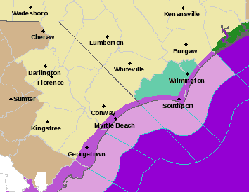
As a result, the area is under a coastal flood watch and a gale watch, according to the National Weather Service in Wilmington.
The most impactful conditions are expected Sunday morning through Sunday evening. The weather service has advised that residents be prepared for isolated power outages, hazardous travel conditions, and possible road closures in low-lying coastal areas.
Here's what you can expect and how you should prepare:
Rainfall
Three to four inches of rain are expected, but some areas could see up to six inches. Rain is expected to begin Saturday night, be the heaviest during the day Sunday, and then continue into Sunday night.
Flooding
Moderate coastal flooding is expected on Sunday, which could cause some beach erosion. Surf heights of 6 to 11 feet will pose dangerous surf conditions.
Moderate coastal flooding means 2 to 3 feet of inundation is possible in normallydry areas near beaches and tidal creeks and rivers. Flooding could be even worse if the heaviest rainfall occurs at high tide.
What roads are expected to flood?
On Figure Eight Island, Oyster Catcher Road and Beach Road may be affected by flooding.
Water is expected to reach North Lumina Ave. in Wrightsville Beach. Canal Dr. from Starfish Lane northward may not be accessible.
In Pender County, the south end of Topsail Beach and from the north of Jolly Roger Pier to the south end of Surf City. The north end of Surf City near the county line may also potentially be susceptible to coastal flooding.
US 421 North at USS N.C.is expected to flood.
River Rd. south of Cape Fear Boulevard will be impassable, according to the National Weather Service. Roads on either side of River Road, south of River Road Park, will flood.
Water St., between Red Cross St. and Orange St., is expected to be impassable. Water may spread further up side streets in this area.
Point Harbor Rd., US 421 Truck near Carolina Beach Rd., Route 133 at Little Mallory Creek, and Old River Rd. at Route 133 may be impassable.
Burnett Rd. at US 421 is also expected to flood.
Wind
Widespread wind gusts of 35 to 50 mph and greater are expected. Impacts will be similar to a tropicalstorm. And there is a marginal risk of tornadoes.
How to prepare
If you must be on the roads, allow extra time because some road flooding is possible. Do not drive around barricades or through water of unknown depth.
Residents who live on flood-prone property should also take action to protect their homes and belongings.
Residents also should secure outdoor furniture and holiday decorations.
This article originally appeared on Wilmington StarNews: Severe weather in Wilmington, NC coast and what to expect
