Severe weather brings threat of tornadoes again Wednesday. See what to expect and when
Severe weather is in the forecast again Wednesday, a day after storms drenched the region, spawning possible tornadoes and causing flooding in Greater Cincinnati.
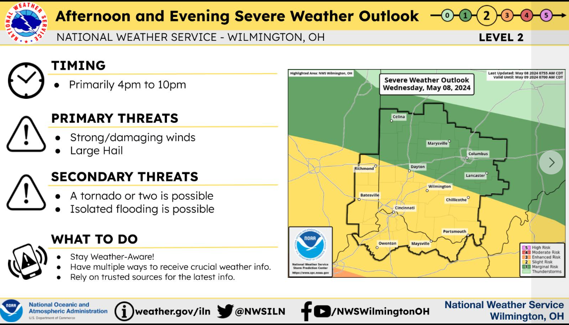
According to a hazardous weather outlook, severe thunderstorms will be possible again Wednesday into the evening. Damaging winds and large hail will be the primary threats, with a few tornadoes possible.
The primary window for severe weather is between 4 and 10 p.m., according to the National Weather Service in Wilmington.
A flood warning remains in effect until 10 a.m. Wednesday in the following counties: Dearborn, Ohio, and Ripley in Indiana; Boone, Campbell, and Kenton in Northern Kentucky; and Brown, Clermont, Hamilton, and Highland in Ohio.
Ohio weather radar
Ohio severe weather outlook
According to the report, flooding of rivers, creeks, streams, and other low-lying and flood-prone locations is imminent or occurring. Numerous roads remain closed due to flooding.
Detailed Forecast
Wednesday: There is a chance of showers and thunderstorms, mainly after 5 p.m. There are Increasing clouds, with a high near 85. The southwest wind is 3 to 6 mph. The chance of precipitation is 30%. New rainfall amounts will be less than a tenth of an inch, except higher amounts are possible in thunderstorms.
Wednesday night: Showers and thunderstorms are likely, followed by showers and possibly a thunderstorm after 2 a.m. The low will be around 64. The south wind will be around 6 mph. The chance of precipitation is 90%. New rainfall will be between a tenth and a quarter of an inch, except higher amounts are possible in thunderstorms.
Thursday: Showers and possibly a thunderstorm, mainly before 2 p.m., then a chance of showers and thunderstorms after 2 p.m. High near 76. West wind 5 to 13 mph. The chance of precipitation is 80%. New rainfall amounts will be less than a tenth of an inch, except higher amounts are possible in thunderstorms.
Thursday night: Showers and thunderstorms are possible before 8 p.m. The sky is mostly cloudy, with a low of around 50. The wind is north at 9 to 14 mph. The chance of precipitation is 30%. New rainfall amounts to less than a tenth of an inch, except higher amounts are possible in thunderstorms.
Severe thunderstorms will be possible again later this afternoon and evening with the highest threats along and south of the Ohio River. pic.twitter.com/TtVWUbMKTB
— NWS Wilmington OH (@NWSILN) May 8, 2024
Friday: There is a slight chance of showers after 2 p.m. It will be partly sunny, with a high near 67. The wind will be north at 7 to 11 mph. The chance of precipitation is 20%.
Friday Night: Partly cloudy, with a low around 49.
Saturday: There is a chance of showers, followed by showers likely and possibly a thunderstorm after 2 p.m. It will be mostly sunny, with a high near 69. The chance of precipitation is 60%.
Sunday: Sunny, with a high near 73.
Monday: There is a chance of showers. It will be mostly sunny, with a high near 78. The chance of precipitation is 30%.
Tuesday: There is a chance of showers and thunderstorms. It will be mostly sunny, with a high near 80. The chance of precipitation is 40%.
Source: National Weather Service, Wilmington.
This article originally appeared on Cincinnati Enquirer: Strong storms could spawn tornadoes Wednesday in Greater Cincinnati
