Severe thunderstorms to ignite in parts of Northeast, Midwest

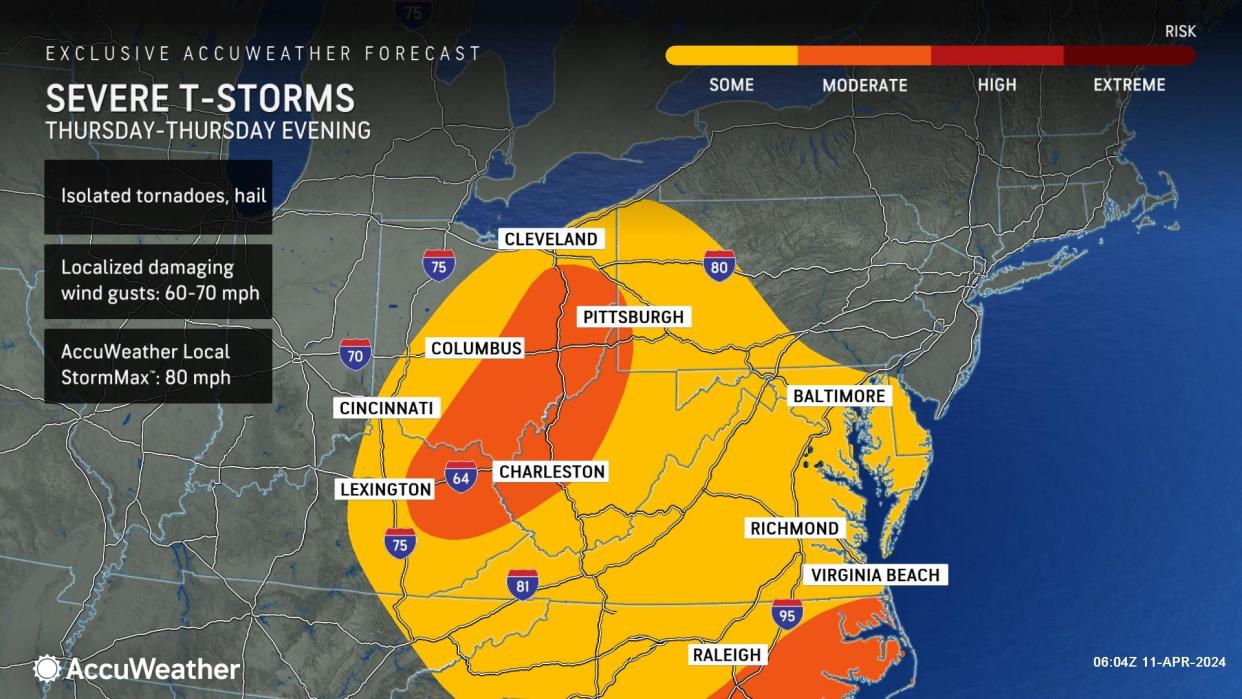


The same storm system that began producing severe weather and torrential rain in the southern United States Monday will pivot northeastward and is poised to set off severe thunderstorms from the mid-Atlantic coast to the Midwest Thursday, AccuWeather meteorologists warn. Some heavy and gusty storms may also roll through New England before the end of the week.
Those with outdoor or travel plans may have to do more than dodge raindrops and flooding in the Midwest and Northeast. Severe weather could ramp up quickly Thursday and potentially bring locally damaging and dangerous conditions.
 |
The full spectrum of severe weather is anticipated on Thursday from Delaware, Maryland and Virginia to eastern Kentucky and much of Ohio.
Cities at risk for severe weather on Thursday include Washington, D.C., and Norfolk, Virginia, in the East and Pittsburgh; Charleston, West Virginia; and Cleveland, Cincinnati and Columbus, Ohio; farther to the west. Charleston, West Virginia, was rocked by severe thunderstorms packing high winds late last week that collapsed roofs, knocked over trees and radio towers and triggered widespread power outages.
 |
In addition to torrential downpours that may trigger flash flooding, the main threats will be powerful wind gusts and hail. The AccuWeather Local StormMax™ wind gust is above the minimum hurricane threshold of 74 mph in the mid-Atlantic and Midwest zones. The StormMax™ for the Midwest storms is 80 mph.
This Midwest region, including portions of western Pennsylvania, West Virginia and the Virginia Panhandle, has a somewhat greater risk of tornadoes than the zone in eastern Virginia and in part of the Delmarva Peninsula.
"But, even the mid-Atlantic zone has the potential to produce a couple of tornadoes, especially around the Chesapeake Bay," AccuWeather Senior Meteorologist Tyler Roys said.
 |
The severe weather in the Midwest will erupt near the center of the storm system, while severe storms extend from northern Florida to at least as far to the north as Maryland and Delaware in the mid-Atlantic along a cold front that will pivot northeastward. Heavy, gusty thunderstorms may continue along the front farther to the north in the Northeast.
Even though storms may be below official severe wind criteria, gusts may still be strong enough to knock down trees and trigger power outages from Philadelphia to New York City on Thursday and later on to Hartford, Connecticut, Boston and Portland, Maine, from Thursday night to Friday.
Along with the likelihood of heavy to severe thunderstorms in the Midwest and Northeast, a period of strong winds from the south and southeast will play on near-shore Atlantic Ocean waters.
 |
Even though the period of strong coastal winds will occur a few days after the new moon when tides are astronomically high, there is the likelihood of minor to moderate coastal flooding from Thursday night to Friday from North Carolina to Maine during the high tide cycles, AccuWeather Senior Meteorologist Dave Dombek said.
Gusts frequenting speeds of 40-50 mph along the coast may cause sporadic power outages. Because the onshore winds and associated wave action will persist for more than 12 hours, some beach erosion is likely at a time when many communities have begun or are finishing up spring preparation for the busy summer season.
 |
Soon after winds flip around to the west and northwest later Friday and Friday night, coastal water levels will recede and tides may dip below published levels for a time into the weekend.
Want next-level safety, ad-free? Unlock advanced, hyperlocal severe weather alerts when you subscribe to Premium+ on the AccuWeather app. AccuWeather Alerts™ are prompted by our expert meteorologists who monitor and analyze dangerous weather risks 24/7 to keep you and your family safer.
