Scientists Are Getting Closer To Understanding This Ancient Stone ”Treasure Map“
The Saint-Belec stone, carved roughly 4,000 years ago, is Europe’s oldest known 3D map. Scholars now call it a “treasure map” to a Bronze Age past.
While the stone was originally discovered in 1900, it wasn’t understood at the time, and has recently been embraced by researchers as a map of the Brittany region, west of Paris.
Researchers are still working to understand everything they can about this stone in order to pry the most information possible out of their treasure map.
The love of treasure maps spans through time—all the way back to the Bronze Age, it appears.
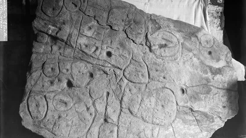
The Saint-Belec slab—a 4,000-year-old, 5-foot by 6.5-foot carved piece of stone—was found to be what researchers are calling a “treasure map” to Bronze Age archaeological destinations back in 2021. Now, experts are beginning to put it to use.
“Using the map to try to find archaeological sites is a great approach. We never work like that,” Yvan Pailler, professor at the University of Western Brittany, told AFP.
Where that “treasure map” leads, though—that’s still the mystery. And it’s one with a truly ancient twist.
The Bronze Age stone slab was originally discovered in 1900, but the implications of its carvings were not understood at the time, and the slab was then lost for another century. In 2014, French researchers rediscovered the stone and the wealth of information it holds in the cellar of a French castle. Since 2021, they’ve been working to better understand just where the map is from.
Now, Pailler and colleague Clement Nicolas of the French National Centre for Scientific Research have come to believe that the region pictured in the map is an 18 mile by 13 mile tract somewhere in the Brittany region—about 300 miles west of Paris. To better understand the incomplete portions of the map, researchers have continued a search the Brittany area where the slab was first discovered.
“We are trying to better contextualize the discovery,” Pailler says, “to have a way to date the slab.”
And so far, it’s working. Researchers have uncovered additional fragments from the stone to help piece together more of the map, and they now believe that the slab was discarded at one point—likely depicting a kingdom since conquered.
By comparing it to modern maps, the team found what they believe is an 80 percent match to the Odet Valley region in Brittany. “There were a few engraved symbols that made sense right away,” Pailler tells AFP. The undulations and lines on the stone showed off rivers and mountains, including what they believe to be the Odet River. “We still have to identify all the geometric symbols,” Nicolas says, “the legend that goes with them.”
Unearthing those little symbols is part of the continued treasure map fun, of course. They could direct researchers to nearly anything, from a burial ground to a unique feature in the land.
Using a Bronze Age map as an archeological guide isn’t common, at least outside of movie plots. But this story won’t wrap up in 90 minutes. In fact, the researchers expect to take over a decade to search out all this Bronze Age map has to offer, treasure or not.
Looks like we can gear up for a fun hunt.
You Might Also Like
