'Rogue' or 'sneaker?' What caused the giant wave in the Marshall Islands
You've probably seen the viral video of a large wave inundating a building. A triple-screen view from several cellphone cameras proves even more impressive. The big wave happened on Saturday, Jan. 20, 2024, on the island of Roi-Namur, part of the Kwajalein Atoll, in the Marshall Islands. The wave caused significant damage to Dyess Army Field and Freeflight International Airport.
Kwajalein Atoll -- colloquially referred to as "Kwaj" by residents -- is a ring of islands in the Pacific Ocean, roughly 1,500 miles northeast of Papua New Guinea. The atoll contains only 3.6 square miles of land -- less than one-fifth the size of Bermuda. Eleven of the 97 islands, including Kwajalein Island and Roi-Namur, where the wave occurred, are leased by the United States military to serve as the Ronald Reagan Ballistic Missile Defense Test Site.
 |
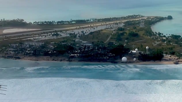
A view, via aircraft, of the damaged area on the north shore of Roi-Namur, an island in Kwajalein Atoll. |
Colonel Andrew "Drew" Morgan, Garrison Commander, U.S. Army Garrison - Kwajalein Atoll, said in a Facebook video, "We had a series of unpredicted, gigantic waves wash over the north point of Roi-Namur. It caused extensive damage that we are still assessing, but luckily, there were only a few minor injuries." Another Facebook video showed the coastal damage from a plane.
More than 80 people were evacuated from Roi-Namur back to Kwajalein Island, Morgan said, where more medical services are available. At the site where the wave hit, 50 soldiers were dropped off to fix utilities and assess damages.
"This is going to go down in Kwaj's history books as one of its most challenging times ever in its 80-year history," Morgan said, noting recovery could take months or even years. "We will get through this. Remember, we're important to the nation's security. This is our home. We love our home."
 |
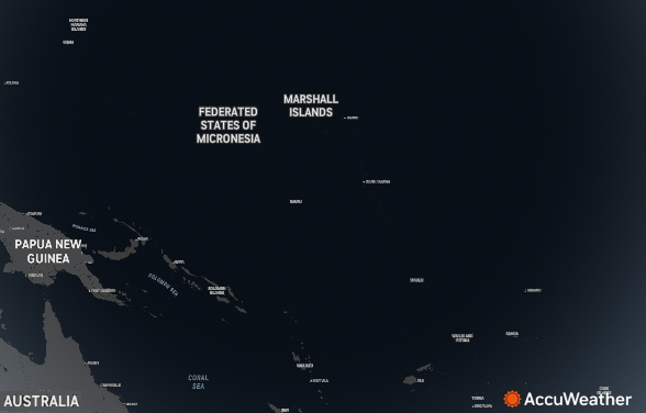
The Marshall Islands, where the wave occurred, are in the Pacific Ocean, northeast of Papua New Guinea and Australia. |
AccuWeather spoke with National Weather Service (NWS) meteorologist Brandon Aydlett from the NWS Guam office about weather and wave conditions ahead of the incident.
Aydlett said they expected a notable wave event several days in advance due to a massive north Pacific cyclone passing well north of the area. The wind field was unusually large and was followed by an abnormally large area of high pressure. The NWS office in Guam issued high seas and high surf warnings for waves over 15 feet for the islands, which is out of the ordinary.
 |
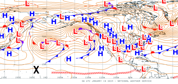
A weather map shows the low pressure system that caused the high surf, northeast of the Marshall Islands, located at the "x" on Jan. 19, 2024 (NOAA) |
Although the NWS office in Guam has received reports of significant inundation from many islands during this event, none have been similar to what was experienced at Roi Namur and shown in the viral video.
While a weather pattern with a strong cyclone and strong high-pressure system was the overall cause, the NWS forecaster's best assessment of what caused the big wave was a complicated story of wave and wind mechanics.
"The motion of the cyclone which, paired with the typhoon-force north winds, likely resulted in a dynamic fetch event," Aydlett told AccuWeather in an email. "This led to a constructive interference of swells of various periods culminating in what occurred at Roi-Namur," Aydlett concluded.
Fetch refers to the distance the wind blows over water in a single direction.
 |
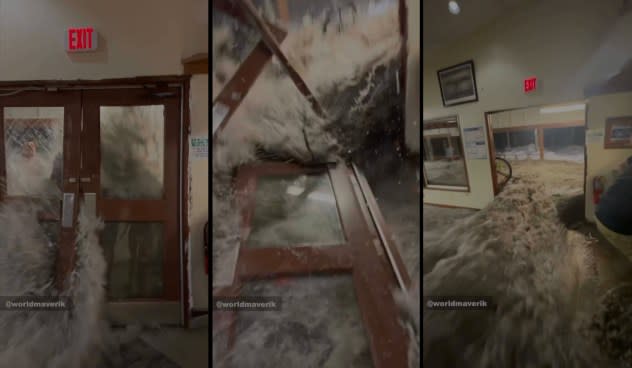
Screen captures from the video of the wave breaking through the doors of a building on Roi-Namur on Jan. 20, 2024 (Erik Hanson) |
Although most media outlets are referring to this event as a "rogue wave," rogue waves are large waves that hit ships at sea, not on shore, according to NOAA. This event was most likely a "sneaker wave," defined as an unusually high wave in a set of waves that hit the shore.
Larry Smith, a meteorologist at the NWS office in Monterey, California, said in 2013, "Though the terms 'sneaker' and 'rogue' wave are often used interchangeably in media reports, Smith considers a 'rogue wave' a different phenomenon, one that occurs out at sea, as a result of wave interactions."
This event was not caused by the storm surge of a tropical storm nor was it a tsunami, which is a large rise in the water level at the shore, usually caused by earthquakes.
Due to the complex nature of winds, waves and bathymetry, or depth of water, individual sneaker waves cannot be predicted today, but recent research indicates that might not always be true. In many cases, however, there were dangerous waves at the locations before sneaker wave damage. To avoid sneaker waves, the NWS advises beachgoers to heed advisories and observe waves before approaching a beach and to be mindful of the ocean.
Want next-level safety, ad-free? Unlock advanced, hyperlocal severe weather alerts when you subscribe to Premium+ on the AccuWeather app. AccuWeather Alerts™ are prompted by our expert meteorologists who monitor and analyze dangerous weather risks 24/7 to keep you and your family safer.
