With reservoirs nearly full and Boise River closely managed, ‘great water season’ ahead
The Boise River boasts three mountain reservoirs — Anderson Ranch, Arrowrock and Lucky Peak — whose primary, and critical, roles are twofold.
Starting in early April and running through June, when there is fast runoff from the melting snowpack, these reservoirs collect water to minimize flood impacts to the city and its residents.
Second, much of what they collect provides water for agriculture throughout the Treasure Valley via a maze of irrigation channels — a necessity once Idaho hits the dry summer months.
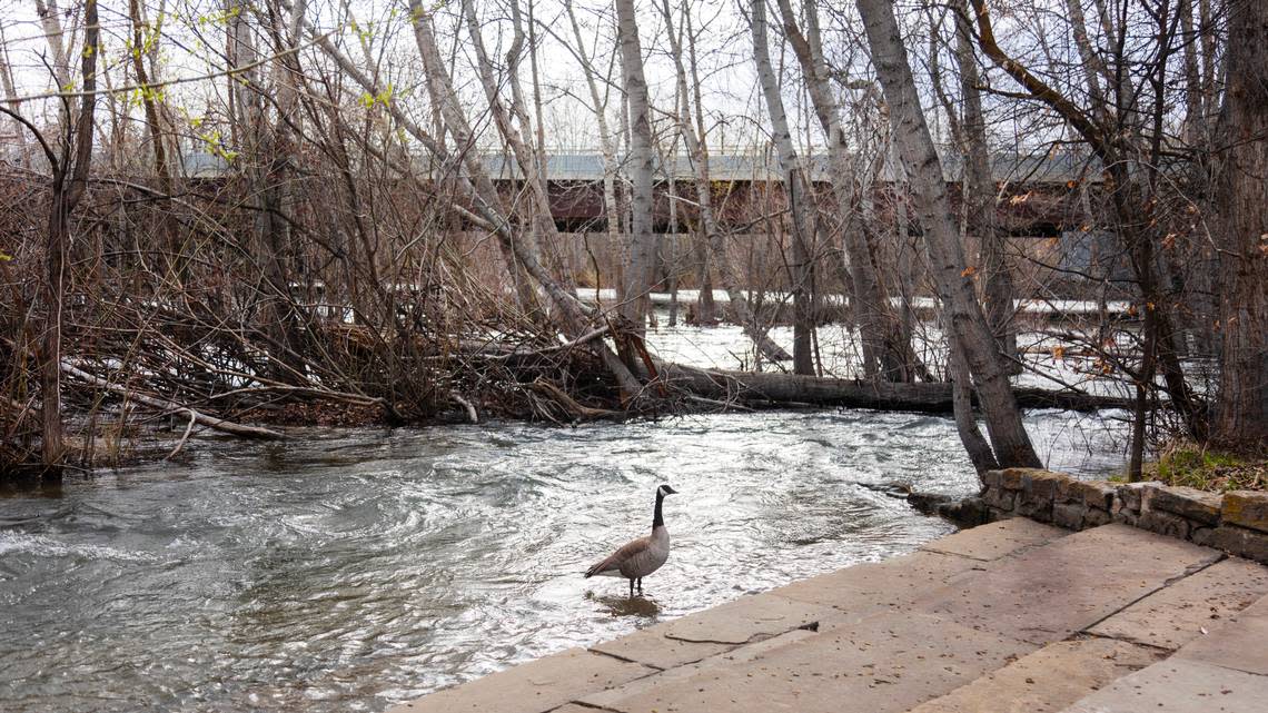
So what’s the outlook this year, which has already seen some flooding in Boise? According to the U.S. Bureau of Reclamation, the Boise Basin is at 97% capacity, as snowmelt and a rainy spring have nearly filled the system.
That means several things, including a chance of continued high river levels and the likelihood that it will be a good water year overall for Treasure Valley cities, as well as for farmers and ranchers in the various irrigation districts.
It also has already meant a delayed start to the popular summertime float season on the river.
Citing “the excellent snowpack and cool weather,” Bob Carter, with the Boise Project Board of Control, said in a phone interview that it’s shaping up to be “a great water season” that likely will extend until mid- or late October, breaking the pattern of drought conditions the past two years.
The Board of Control oversees five major irrigation districts in the Treasure Valley, and Idaho’s drought was bad enough in 2021 that water was shut off more than a month early to users. Last year saw shutoffs that were only a week or two early in most cases.
Who are the Boise River water level puppeteers?
The decision of how much water to keep in reservoirs and how much to let flow into the Boise River is a careful balancing act.
The level is controlled in part by the U.S. Army Corps of Engineers. Jon Roberts, the water management lead for the Corps’ Walla Walla District, said in a phone interview that it’s an enormously collaborative effort between a wealth of agencies.
In the Boise Basin, six to 10 engineers and scientists are responsible for managing the flows at any given time. The agencies these experts represent include the Bureau of Reclamation, the National Weather Service, NOAA’s Northwest River Forecast Center and the Department of Agriculture’s Natural Resources Conservation Service.
The flow rates are revised daily, based on recent weather and historic snowfall records, according to Roberts.
Those in charge analyze snow telemetry (SNOTEL) data from a network of over 900 automated collection sites located in remote, high-elevation watersheds across the West. Each site hosts a “snow pillow” that weighs the snow on top of it and estimates snow moisture content. Combined with satellite imagery, data are used by the team to update estimates of snowpack and snowmelt.
“We’re constantly coming up with better ways to forecast snowpack,” Roberts said.
How much water is too much water?
In the Snowmageddon winter of 2016-17, Boise saw 39.1 inches of snowfall, with 21 inches in January 2017 alone.
The following spring brought unprecedented flooding to the city.
Roberts said there was so much snow in the region, the water release was spread out over 100 days — as opposed to the usual 60. Even then, Roberts said the city saw “catastrophic consequences.”
River flows are typically measured in cubic feet per second (cfs), which notes the volume of water flowing past a stationary point each second. A single cubic foot of water is roughly 7.5 gallons.
Flood stage begins at 7,000 cfs, and if the flow gets to be 10,000 cfs, very significant damage will occur.
The maximum Boise River flow rate in 2017 was 9,590 cfs, and the impact could be seen across the city, in flooded houses, parking lots and playgrounds. Eroded and saturated root systems led to many problems with fallen trees and debris in and along the river.
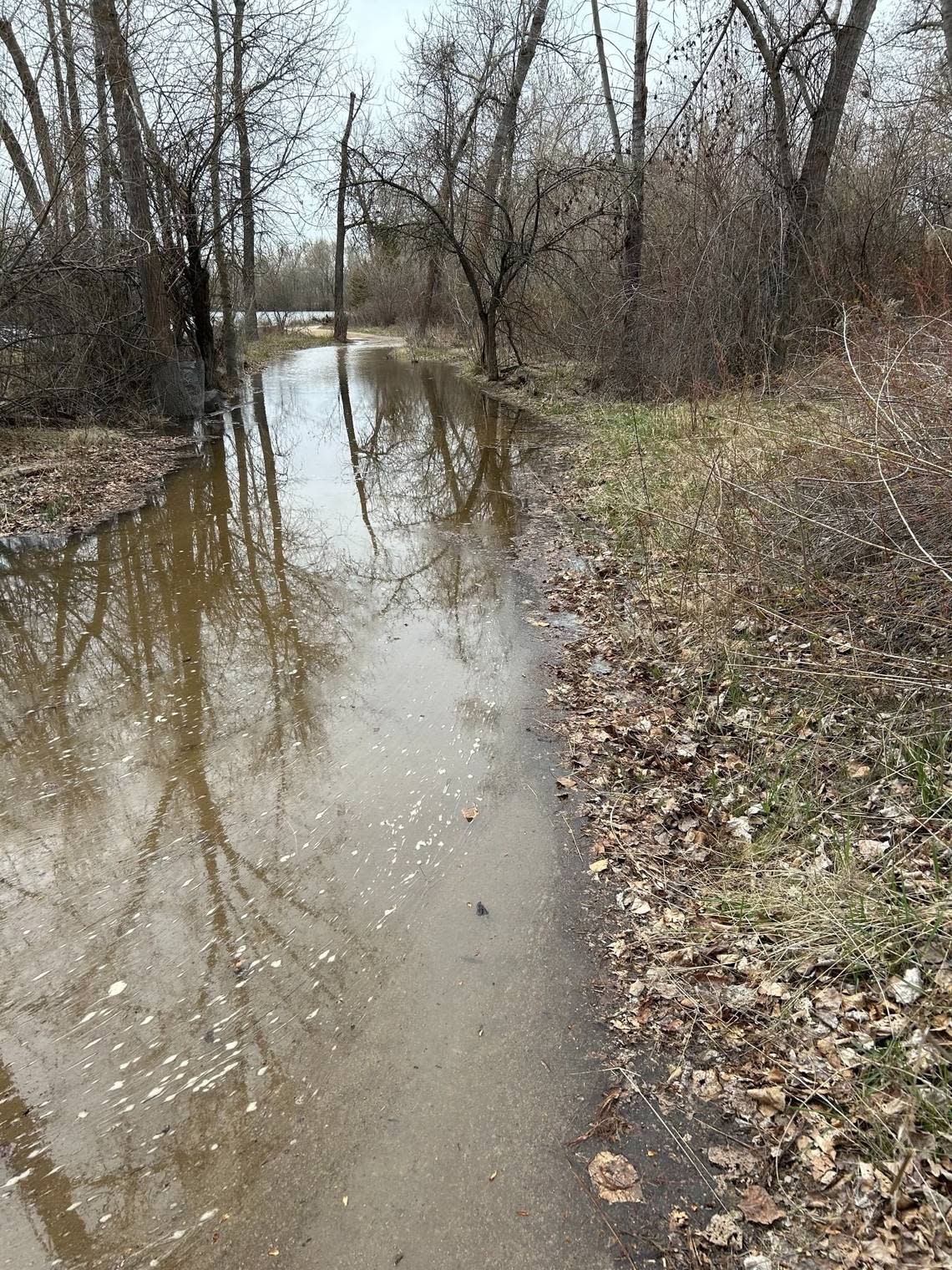
The Boise region received 83% of normal snowfall last winter, and the max flow rate this spring has been about 6,000 cfs, Roberts said. But he noted “that rate is still impactful” because all it takes is 4,000 cfs to affect lower-lying areas.
This year, significant swaths of the Greenbelt have been closed because of flooding, and officials posted a “dangerous river notice” in April, warning people not to try to recreate. The Boise River claimed the life of a kayaker not long after that.
Got an interesting science-related story? Julie Jung is an American Association for the Advancement of Science fellow working with the Idaho Statesman this summer. She has degrees from Williams College (B.A.) in Massachusetts and Boston University (M.A. and Ph.D.), and is doing postdoctoral work at the University of Utah. Reach her at jjung@idahostatesman.com with comments and story ideas.
