Rain, storms and cooler temperatures in weather forecast for North Texas through weekend
Rain, storms and cooler temperatures are possible in North Texas through Saturday, according to the National Weather Service in Fort Worth.
On Thursday, the best chances for rain and storms will be in the afternoon and evening, according to Monique Sellers, a meteorologist for the National Weather Service. Localized heavy rain could cause flooding in some areas, and strong winds and small hail are possible, but Sellers said it is unlikely that there will be severe storms in the Dallas-Fort Worth Metroplex.
Thursday’s weather will feature a wavering stationary front across the area with cool temperatures in the 60s to the north of it, and warm temps in the 70s and 80s to the south of it. The best chances of rain will be across northern parts of North Texas in the afternoon, but this will shift southward as the front begins to push back to the south Thursday night, according to the weather service.
Drier air will move in Friday, but another system over the weekend could bring more rain to the area. Sellers said there is a potential of severe storms to the east and north of the Metroplex on Saturday.
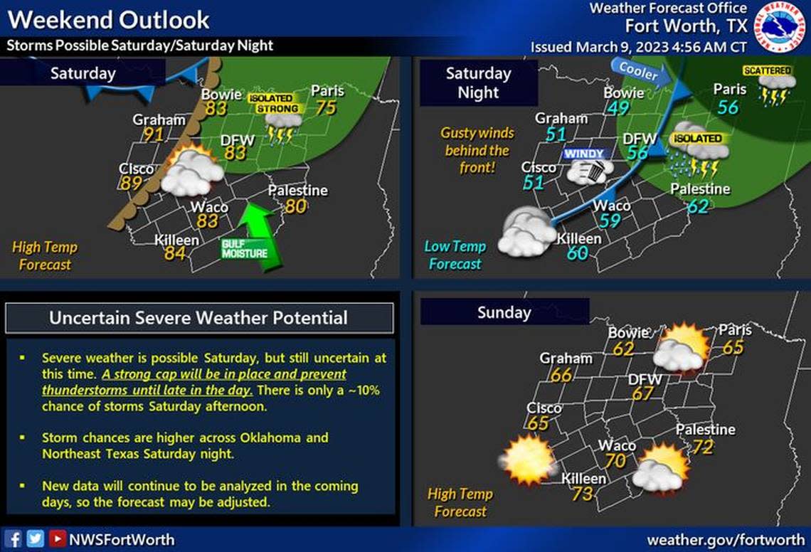
Saturday will be warm and breezy with highs in the 80s for most. A dryline will advance into North Texas late in the day that may support the development of thunderstorms in the afternoon, the weather service said.
Currently, there is only about a 10% chance of thunderstorms Saturday afternoon, but if storms are able to develop, they are likely to become strong or severe.
Thunderstorm chances are higher over Oklahoma and Northeast Texas on Saturday night. A cold front will move through and bring gusty winds and cooler temperatures to the region.
Widespread severe weather is not in the forecast, but residents should continue to monitor the weather as conditions could evolve.
High temperatures will remain in the 60s and 70s at least through Sunday.
Sunday will be mostly sunny with a high around 68.
3-Day Storm Outlook
This map shows the 3-day weather outlook for storms by the National Weather Service's Storm Prediction Center. Sources: National Weather Service, Esri.
Current Temperatures
Current temperatures and weather data from NOAA weather stations updated hourly. Tap on the map for current weather conditions, including humidity, wind speed. and direction. Data provided by NOAA and Esri.
