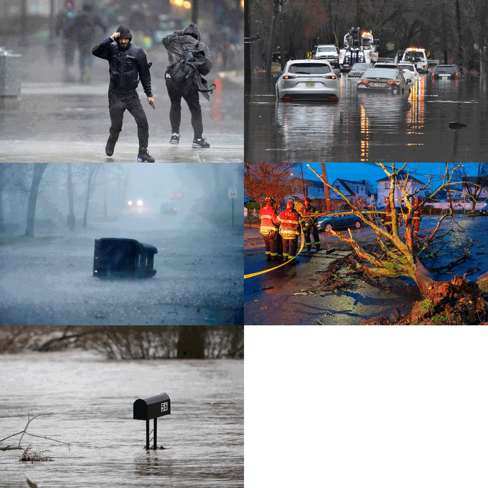
Powerful storm dumps heavy rain over East Coast with 59M under flood alerts
A powerful storm raced up the East Coast on Monday, causing at least two deaths, putting millions of people under flood alerts, cutting power to about 775,000 utility customers, and thwarting pre-holiday flights.
A 40-year-old man was killed after he was struck by part of a tree in Windham, Maine, as he was clearing a branch from his roof, Windham Police Chief Kevin O. Schofield said in a statement. He said the man, Troy Olsen, was pronounced dead at the scene.
An 89-year-old man in Hanover, Massachusetts, was killed when a tree struck the travel trailer he was in Monday morning, Plymouth County District Attorney Timothy J. Cruz said in a statement.
The victim was hospitalized with severe head trauma and later died, Cruz said. He was identified as Robert Horky of Hingham.
In Cohasset, Massachusetts, a mother and her infant survived with minor injuries after a branch hit the vehicle they were in on Monday morning, Cohasset police said in a statement.
A slight risk of excessive rainfall over parts of New England remained through Tuesday, even as the storm exited the United States en route to Canada and the North Atlantic, National Weather Service forecasters said.
“The associated heavy rain will create mainly localized areas of flash flooding, with urban areas, roads and small streams the most vulnerable,” the weather service said.

The same storm system battered Florida and the Carolinas with strong winds and torrential rain over the weekend. Charleston set a daily record Sunday with 3.86 inches of rainfall, and Gainesville, Florida, reported more than 7 inches. South Carolina also set a record for greatest storm surge from a nontropical system with a high tide at almost 10 feet.
The low-pressure system raced from Florida to Maine in 36 hours, fueled by subtropical humidity from the Atlantic that clashed with cooler air moving in behind it, forecasters said.
The system produced the lowest ever air pressure readings on record for the month of December off the Southeastern coast, including Florida, and was extraordinarily warm, largely because the Atlantic's sea surface temperatures have been above normal, said Brian Horley, senior meteorologist with the weather service's Weather Prediction Center.
Low pressure helps draw warm humid air that the counterclockwise system turns into rain, and Horley said the record readings correlated to serious flooding in places like coastal South Carolina, where more than 1 foot of rain was recorded.
"It was a super-warm system for the month of December," he said.
The East Coast, from Virginia to Maine, was targeted by similar fury Monday. By 6:30 p.m., about 775,000 homes and businesses from New Jersey to the U.S.-Canada border were in the dark, according to PowerOutage.us.
In New York City, a travel advisory is in effect because of flooding conditions on roads, power outages and high winds on bridges. The city’s emergency management office also warned of “imminent” flash flooding in Manhattan and the Bronx, warning locals to avoid basements and low-lying areas.
At one point in the day, more than 10,000 people in New York City were without power because of the storm, and there were 388 reports of downed trees across the city, the city's Emergency Management Office said.
Con Edison crews restored power to a vast majority of those customers by late afternoon, with fewer than 2,000 homes and businesses in the dark by 5 p.m.
In Connecticut, the Danbury Emergency Management Office urged people to avoid flooded roads in the city, where there were reports of water rescues and vehicles stuck in water. Part of Boston's Massachusetts College of Art and Design’s tower building exterior also sustained damage. There were no injuries in the damage.
Amtrak said train services were temporarily disrupted between Providence, Rhode Island, and Boston because of “overhead power issues.”
Flooding struck parts of New Hampshire on Monday morning, too, with Jed Henry, chief of the fire department in Jackson, saying it was worse than a hurricane.
The electricity company Central Maine Power shared dramatic photos of the storm damage across Maine today, showing downed structures and toppled trees blocking roads.
In parts of New Jersey, flooded streams and creeks turned streets into rivers.
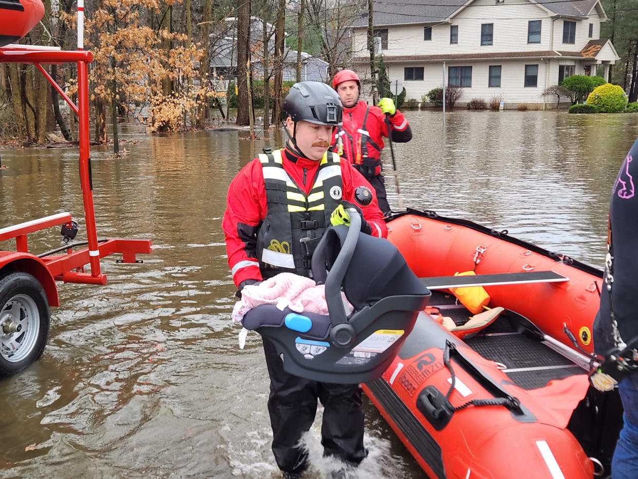
Water rescues were conducted in flooded parts of Hillsdale, New Jersey, Monday morning. The Hillsdale Fire Department shared a photo showing the rescue of a baby after a family’s home was impacted by floods.
Capt. Sean Smith said Glendale Drive is a “flood zone, it hasn’t flooded this bad in a while.”

The village of Moretown, Vermont, was also evacuated because of “significant” flooding, Fire Warden Stefan Pratt said, estimating 30 to 50 houses were in the evacuation zone.
Nearly 4,000 flights have been delayed nationwide and more than 500 canceled, according to FlightAware data, numbers likely to keep growing Monday ahead of holiday travel chaos that sees millions take to the skies a week ahead of Christmas. It comes after a weekend that saw a dizzying number of delays — more than 10,000 — and almost 200 cancellations.
As many as 14 million people in the East were under wind alerts early Monday afternoon. In the past 48 hours, Boston clocked a 68 mph wind gust; New York’s LaGuardia Airport a 54 mph gust; and Weymouth, Massachusetts, a 63 mph gust.
By the end of today, every single state on the East Coast will have experienced at least 2 inches of rain.
The threat of heavy rain will end Tuesday as the system moves further into Canada by Monday evening.
Lake-effect snow downwind of the Great Lakes and upslope snow over parts of the northern and the central Appalachians are also in the forecast Monday through Wednesday, the weather service said.
The heaviest snow Monday will fall over parts of the central Appalachians, southwest of Lake Michigan in Michigan and Indiana, and along the central and the eastern shores of Lake Erie in Ohio and New York. The lake-effect snow will lighten up Tuesday and end over the upper Great Lakes, forecasters said.
Meanwhile, a storm is moving onshore over the West Coast on Monday that will also produce significant rainfall, as well as snow in the Sierra Nevada over the next few days.
