Potential tropical cyclone could drench the US East Coast on Friday
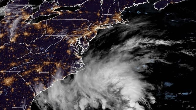
The National Hurricane Center issued a Tropical Storm Warning Thursday for the U.S. Atlantic coast from North Carolina to Delaware. A storm gaining strength offshore is expected to bring heavy tropical storm-force winds and storm surge to the region starting on Friday.
On Thursday night the storm was about 340 miles southeast of Charleston, South Carolina.
As of Thursday night, A Storm Surge Warning was in effect for Duck North Carolina to Chincoteague Virginia, Chesapeake Bay south of Windmill Point, Neuse and Pamlico Rivers and portions of Pamlico and Albemarle Sounds.
A Tropical Storm Warning was in effect for Cape Fear North Carolina to Fenwick Island Delaware, Albemarle and Pamlico Sounds, Tidal Potomac south of Cobb Island and Chesapeake Bay south of North Beach
A Storm Surge Watch was in effect for Surf City to Duck North Carolina, Chesapeake Bay north of Windmill Point to Smith Point, Tidal Potomac south of Colonial Beach and the remainder of Pamlico and Albemarle Sounds.
SEE MORE: What is the difference between a tropical storm and hurricane?
"There is a danger of life-threatening storm surge inundation over portions of eastern North Carolina and southeastern Virginia, including the Pamlico and Albemarle Sounds, and the lower Chesapeake Bay, where Storm Surge Warnings are in place," the National Hurricane Center wrote. "Residents in these areas should follow advice given by local officials."
Tropical storm conditions are expected to begin on Friday and extend into at least Saturday, the National Hurricane Center said.
Storm surge of as much as 5 feet could affect the Neuse, Bay, Pamlico and Pungo Rivers. Rainfall of as much as 7 inches could fall in places across eastern North Carolina into southeast Virginia Friday into Saturday.
Officials urged residents to stay up to date on the storm's progress, and gather supplies and prepare for the arrival of hazardous weather conditions.
